Cedar Hill, Missouri
| Cedar Hill, Missouri | |
|---|---|
| Census-designated place | |
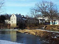 Dam on the Big River at Cedar Hill | |
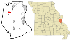 Location of Cedar Hill, Missouri | |
| Coordinates: 38°21′22″N 90°38′30″W / 38.35611°N 90.64167°WCoordinates: 38°21′22″N 90°38′30″W / 38.35611°N 90.64167°W | |
| Country | United States |
| State | Missouri |
| County | Jefferson |
| Area | |
| • Total | 2.29 sq mi (5.94 km2) |
| • Land | 2.29 sq mi (5.94 km2) |
| • Water | 0.0 sq mi (0.0 km2) |
| Elevation | 550 ft (168 m) |
| Population (2010)[1] | |
| • Total | 1,721 |
| • Density | 750/sq mi (289.5/km2) |
| Time zone | UTC-6 (Central (CST)) |
| • Summer (DST) | UTC-5 (CDT) |
| ZIP code | 63016 |
| Area code(s) | 636 |
| FIPS code | 29-12358[2] |
| GNIS feature ID | 0737691[3] |
Cedar Hill is an unincorporated community and census-designated place (CDP) in Jefferson County, Missouri, United States. The population was 1,721 at the 2010 census.[1]
History
A post office called Cedar Hill has been in operation since 1868.[4] The community was named for cedar trees near the elevated town site.[5]
Geography
Cedar Hill is located in northwestern Jefferson County at 38°21′22″N 90°38′30″W / 38.35611°N 90.64167°W (38.356193, -90.641681).[6] It is 32 miles (51 km) southwest of downtown St. Louis. Missouri Route 30, a four-lane highway, runs through the western side of the CDP, leading northeast into St. Louis and west 22 miles (35 km) to St. Clair.
According to the United States Census Bureau, the CDP has a total area of 2.3 square miles (5.9 km2), all of it land.[1] The Big River, a north-flowing tributary of the Meramec River, forms the southern and western limits of the CDP, and the community is the site of an old mill and dam.
Demographics
As of the census[2] of 2000, there were 1,703 people, 627 households, and 465 families residing in the CDP. The population density was 741.6 people per square mile (285.9/km²). There were 657 housing units at an average density of 286.1/sq mi (110.3/km²). The racial makeup of the CDP was 97.89% White, 0.06% African American, 0.82% Native American, 0.18% Asian, 0.35% from other races, and 0.70% from two or more races. Hispanic or Latino of any race were 0.82% of the population.
There were 627 households out of which 38.8% had children under the age of 18 living with them, 56.5% were married couples living together, 11.5% had a female householder with no husband present, and 25.7% were non-families. 19.6% of all households were made up of individuals and 7.0% had someone living alone who was 65 years of age or older. The average household size was 2.72 and the average family size was 3.11.
In the CDP, the population was spread out with 27.2% under the age of 18, 9.9% from 18 to 24, 30.0% from 25 to 44, 24.7% from 45 to 64, and 8.2% who were 65 years of age or older. The median age was 35 years. For every 100 females, there were 97.1 males. For every 100 females age 18 and over, there were 95.1 males.
The median income for a household in the CDP was $35,481, and the median income for a family was $43,214. Males had a median income of $40,160 versus $21,074 for females. The per capita income for the CDP was $15,599. About 5.7% of families and 12.9% of the population were below the poverty line, including 6.1% of those under age 18 and 8.8% of those age 65 or over.
References
- 1 2 3 "Geographic Identifiers: 2010 Census Summary File 1 (G001): Cedar Hill CDP, Missouri". American Factfinder. U.S. Census Bureau. Retrieved August 17, 2018.
- 1 2 "American FactFinder". United States Census Bureau. Archived from the original on 2013-09-11. Retrieved 2008-01-31.
- ↑ "US Board on Geographic Names". United States Geological Survey. 2007-10-25. Retrieved 2008-01-31.
- ↑ "Post Offices". Jim Forte Postal History. Archived from the original on 19 October 2016. Retrieved 18 October 2016.
- ↑ "Jefferson County Place Names, 1928–1945 (archived)". The State Historical Society of Missouri. Archived from the original on 24 June 2016. Retrieved 19 October 2016.
- ↑ "US Gazetteer files: 2010, 2000, and 1990". United States Census Bureau. 2011-02-12. Retrieved 2011-04-23.
Municipalities and communities of Jefferson County, Missouri, United States | ||
|---|---|---|
| Cities | 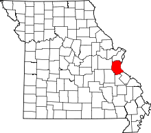 | |
| Villages | ||
| Townships | ||
| CDPs | ||
| Unincorporated communities | ||