Bathinda
| Bathinda | |
|---|---|
| City | |
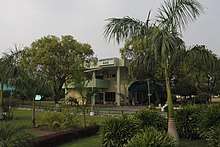
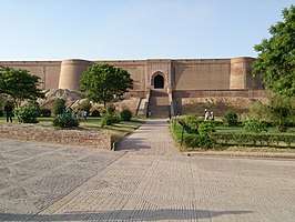 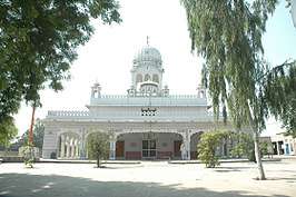 Top: Qila Mubarak, the landmark of Bathinda City Bottom: Gurdwara Sahib, Bhatinda | |
 Bathinda  Bathinda | |
| Coordinates: 30°13′48″N 74°57′07″E / 30.23000°N 74.95194°ECoordinates: 30°13′48″N 74°57′07″E / 30.23000°N 74.95194°E | |
| Country |
|
| State | Punjab |
| District | Bathinda |
| Government | |
| • Body | Municipal Corporation |
| • Commissioner | Sh. Anil Kumar Garg |
| • Member of Parliament | Harsimrat Kaur Badal (SAD) |
| • Mayor | Sh. Balwant Rai Nath |
| Elevation | 210 m (690 ft) |
| Population (2011) | |
| • Total | 285,813 |
| • Rank | Punjab: 5th, India: 161st |
| Languages | |
| • Official | Punjabi |
| Time zone | UTC+5:30 (IST) |
| PIN | 15100X |
| Telephone code | +91-164-XXX XXXX |
| Vehicle registration | PB-03 |
| Railways Stations in City | Bathinda railway station |
| Website |
www |
Bathinda (in Punjabi ਬਠਿੰਡਾ also known as Tabar-e-Hind or Tabarhindh meaning the Gateway to India) is a city and Municipal Corporation in Southern part of Punjab, India. It is one of the oldest cities in Punjab, India and the current administrative headquarters of Bathinda District. It is in northwestern India in the Malwa Region, 227 km west of the capital city of Chandigarh and is the fifth largest city of Punjab. Bathinda's nicknamed the 'City of Lakes', courtesy of the artificial lakes in the city. The first empress of India, Razia Sultan was imprisoned in the Qila Mubarak fort in Bathinda.[1] The gurudwara and mazaar of Haji Rattan is a popular tourist centre of Bathinda having connections with popular legends.[2]
Bathinda is a home of Central University of Punjab and upcoming AIIMS. Bathinda is home to two modern thermal power plants, Guru Nanak Dev Thermal Plant and Guru Hargobind Thermal Plant at Lehra Mohabbat.[3] The city has a fertilizer plant,[4] a large oil refinery, two cement plants (Ambuja Cements and UltraTech Cement Limited), a large army cantonment, an air force station, a zoo,[3] and a historic Qila Mubarak fort.[5] Bathinda is one of the largest food grain and cotton markets in northern India; the area around Bathinda is a prolific grape growing area.
History
Bhatinda was changed to Bathinda to conform to the phonetical expression as locally pronounced.[6] According to Henry George Raverty, Bathinda was known as Tabarhindh (Labb-ut-Twarikh). The earliest mention of Tabarhindh occurs in the Jami-Ul-Hakayat written about 607 Hijri or 1211 AD.
In 1004, Mahmud of Ghazni besieged the local fort, which was located on the route from the northwest into the rich Ganges valley.
In 1189, Muhammad Ghori attacked and occupied the fort of Bathinda. Prithvi Raj Chauhan, the ruler of this region, managed to recover possession of the fort thirteen months later in 1191 after the first battle of Tarain.
In 1634, a battle named Battle of Lahira (at Lahira in Bathinda) was fought between Guru Hargobind and Mughals.
In circa 1754, the town was conquered by Maharaja Ala Singh, the Maharaja of Patiala and since then it followed the history of erstwhile princely state of Patiala. With the dawn of independence and merger of Patiala and East Punjab States into a division called PEPSU, Bathinda become a full-fledged district with headquarters at Bathinda city.[6]
Demographics
Population
As per provisional reports of Census India, population of Bathinda city in 2011 is 285,813; male and female are 151,782 and 134,031 respectively. The sex ratio of Bathinda city is 868 females per 1000 males. The number of literate people in Bathinda city are 211,318 of which 118,888 are males while 92,430 are females, average literacy rate is 82.84 percent of which male and female literacy is 87.86 and 77.16 percent respectively. Total children (ages 0 to 6) in Bathinda city are 30,713: 16,472 boys and 14,241 girls. Child sex ratio of girls is 865 per 1000 boys.[7]
Religion
Hinduism is the majority religion in Bathinda city with 62.61% people following the faith. Sikhism is the second most popular religion in the city which is followed by 35.04% of the people. Minorities are Muslims, Christians, Buddhists and Jains. Sikhs count for 70.89% of the population in Bathinda District on a whole in spite of not being a majority in the city.[8]
Geography and climate
Bathinda is in the northwestern region of India and is a part of the Indo-Gangetic alluvial plains. The exact cartographic co-ordinates of Bathinda are 30°12′N 74°57′E / 30.20°N 74.95°E.[10] It has an average elevation of 201 metres (660 ft).
| Bathinda | ||||||||||||||||||||||||||||||||||||||||||||||||||||||||||||
|---|---|---|---|---|---|---|---|---|---|---|---|---|---|---|---|---|---|---|---|---|---|---|---|---|---|---|---|---|---|---|---|---|---|---|---|---|---|---|---|---|---|---|---|---|---|---|---|---|---|---|---|---|---|---|---|---|---|---|---|---|
| Climate chart (explanation) | ||||||||||||||||||||||||||||||||||||||||||||||||||||||||||||
| ||||||||||||||||||||||||||||||||||||||||||||||||||||||||||||
| ||||||||||||||||||||||||||||||||||||||||||||||||||||||||||||
Bathinda's climate corresponds to semi-arid with high variation between summer and winter temperatures. Average annual rainfall is relatively low, in a range of 20 mm to 40 mm.[11]
In recent times, Summer temperaures of 49 °C (120 °F)[12] and winter temperatures of 1 °C (about 33 °F)[13] were not unknown in Bathinda, lowest being -1.4 °C (29.48 °F) in the winter of 2013[14]
Industry and Economy
Bathinda is an upcoming industrial city. Major industries in the city and its suburbs include:
- National Fertilizer Ltd, Bathinda
- Guru Nanak Dev Thermal Plant, Bathinda (will be decommissioned soon)
- Ambuja Cements Ltd, Malout Road, Bathinda
- Guru Gobind Singh Refinery, a joint project between HPCL and Mittal Energy Limited.
- Ultra Tech Cement Ltd, Lehra Mohabbat
- Guru Hargobind Thermal Plant, Lehra Mohabbat
- Bathinda District Co-op Producer Union Milk Plant, Bathinda
- Vardhman Polytex Ltd, Badal Road, Bathinda
- BCL Industries & Infrastructure Ltd, Hazi Rattan, Bathinda [15]
Several sugar mills, brick kilns, and food processing plants are also located in the city and its suburbs.
Transportation
Bhatinda Railway Station has connectivity to most of the major cities in India. Three national highways, NH 7 (Fazilka - Badrinath National Highway) and NH 54 (Dabwali - Pathankot National Highway) and NH 148B (Bathinda to Kotputli) pass through the city.[16]. Like most cities in Punjab, Bathinda is also well connected by bus to major nearby cities. Buses provide to and fro connectivity to Chandigarh, Ludhiana, Jalandhar, New Delhi, Shimla, Amritsar, Jaipur and several other cities. Bathinda Airport, which shares its runway with the Air Force station in Bhisiana, opened to the public in 2016. As of 2018, flights ply only to and from Jammu and New Delhi.
Places of Interest
Qila Mubarak
Qila Mubarak, also known locally as the Razia Sultana fort is located in the heart of the city. It is one of the oldest forts in India and has a great historical significance. Razia Sultana, the first Empress of Delhi, was imprisoned in the fort. It is maintained by the Archaeological Survey of India and is frequented by both local and foreign tourists.
Damdama Sahib
Damdama Sahib is a Sikh gurudwara in Talwandi Sabo, a suburb 28km southeast of the city. It is known for being the place where the tenth Sikh guru prepared the final version of the Sri Guru Granth Sahib, the definitive Sikh scripture. It is one of the Panj Takhts, or five seats of temporal authority of Sikhism.
Maiser Khana
Maiser Khana is a famous Hindu temple dedicated to goddess Jwala Ji, situated 29km southeast of the city. It is known for two grand melas (fairs) held every year, visited by tens of thousands of devotees.
Education
School Education & Exam Coaching Institutions
The city has many prestigious school chains too - S.S.D. Senior Secondary School (Boys) is one of the oldest educational institutes and many English medium schools have also come up in the city during the last 30 years. DAV Public School, Delhi Public School and Police Public School have their branches in the city. Several reputed Catholic schools are present in the city, such as St. Joseph's convent school and St. Xavier's Senior Secondary School. Other schools include Shri Guru Hargobind Convent School (Nathana) and St. Paul's High School (affiliated to ICSE board). Bathinda is also a hub for competitive examination coaching. Several coaching institutes for medical (NEET, AIIMS) and non-medical (JEE Main, JEE advanced) entrance examinations are present in the city. This has led to a large youth population influx into Bathinda, especially around the Ajit Road area. The city also has institutions for preparation of competitive examination like CAT, S.S.C., Bank etc.
College Education
The city has many colleges (both government and private) offering graduate and post-graduate courses. Some of them are:
- DAV College [17]
- Government Rajindra College, Bathinda
- Guru Kashi University
- Baba Farid College
Central University of Punjab
The Central University of Punjab Bathinda (Punjab) has been established through the Central Universities Act 2009 which received the assent of the President of India on 20 March 2009. Its territorial jurisdiction extends to the whole State of Punjab.
It started its functioning from Camp Office in April 2009, which happens to be the residence of the Vice Chancellor, and from November 2009 it shifted to its City Campus spread over an area of 35 acres. Construction of the main campus has started on 540 acres of land in Ghudda Village (21.5 km from Bathinda ISBT) on Badal Road. Engineers India Limited, a Navratna Public Sector Undertaking, is providing PMC services for the project.[18]
Maharaja Ranjit Singh Punjab Technical University
Maharaja Ranjit Singh Punjab Technical University (MRSPTU), formerly Maharaja Ranjit Singh State Technical University, is a State technical university of Punjab located in Bathinda, Punjab, India. It was established in 2015 and has jurisdiction over 11 districts namely Bathinda, Ferozepur, Moga, Faridkot, Sri Muktsar Sahib, Barnala, Mansa, Sangrur, Patiala, Fatehgarh Sahib and Fazilka. University will function from upgraded Giani Zail Singh Punjab Technical University Campus.[19]
Adesh Institute of Medical Science and Research
Adesh Institute of Medical Sciences & Research (AIMSR) is a private not for profit Medical College associated with a 750-bed Tertiary Care Teaching hospital. It has 150 M.B.B.S. annual seat intake. The college is located on the Barnala Bathinda Highway. The college was established in 2006 under Adesh Institutions. AIMSR is approved by Medical Council of India and permitted by Ministry of Health & Family Welfare. It was affiliated to Baba Farid University of Health Sciences, Faridkot from 2006 to 2011 MBBS Admissions Batch and is affiliated to Adesh University, Bathinda starting 2012.
Sports
Bathinda (and the Malwa region of north India) has always been active in the field of sports. Several eminent sporting personalities were born or were trained in Bathinda (see Notable People). The city has a full-sized hockey stadium with Astroturf, an all-seater multipurpose sports stadium with capacity of over 10,000, a cricket ground (part of Police lines), a Golf course (Part of Cantonment), and several other multipurpose stadiums at Thermal colony, Railway Colony etc. There are also several indoor sports complexes, a tennis academy, several full-sized basketball courts, olympic-sized swimming pools, and a horse-riding club in the city. The city was approved as a site for development of an international cricket ground in 2007, but the plan was scrapped 8 years later due to lack of funds.
Shopping and Entertainment Centers
- City Center Mall — Built by Amravati Infrastructure in collaborated with the Satya Group, this is the city's first mall.[20] It is designed by India 's ace architect Mr. Mohit Gujral.[21] The mall is spread across 1,00,000 sqr. ft. space.[22]
- Mittal's City Mall — Built by Ganpati Township ltd, it is considered to be an entertainment and retail project.[23] City Mall is spread over 3 lakh square feet and it has 8 floors.[24]
- Peninsula Mall — Built by HBN group the mall consists of around 2,50,000 sq. ft of retail space, sprawling across 5 floors with a view of lakes.[25]
- Chill-o-Thrill water park
- Rose Garden
- Bir Talab Zoo and Deer Safari
Military Bases
Due to its proximity to the border, Bathinda has two strategically important military bases.
- Bathinda Cantonment is one of the largest in India. It lies just east of the city border, and the NH 7 passes through it. It houses one of the biggest ammunition depots in the country.
- Bathinda Air force station lies in Bhisiana, which lies 20km north west of the city center. Along with regular aircraft, it also houses unmanned aerial vehicles and early warning aircraft. The station also doubles as a civil domestic airport for the city.
Notable People
- Harbhajan Mann, actor and singer
- Rajinder Gupta, businessman, founder of TridentGroup
- Mehar Mittal, actor and producer
- Mayank Markande, cricketer
- Manny Aulakh, Canadian international cricketer
- Avneet Sidhu, Commonwealth games gold winning shooter
- Parduman Singh Brar, Shotputter, Asiad gold medallist
- Balkar Sidhu, singer
- Amrit Maan, actor, singer and lyricist
- Balwant Gargi, writer and dramatist
- Amardeep Singh Gill, film director
- Riaz ur Rehman Saghar, Pakistani poet and lyricist
- Gurdial Singh, novelist
- Kuldeep Manak, singer
- Janmeja Singh Sekhon, politician
Environmental Issues
There has been increasing incidence of various types of cancer in and around Bathinda. It is attributed to the presence of polluting industries and the indiscriminate use of modern pesticides and other toxic materials in farming. A 2007 epidemiological study found that the surface waters of Bathinda are contaminated with arsenic, cadmium, chromium, selenium and mercury primarily due to the discharge of untreated waste water from surrounding industries. Unscientific farming practices, that emerged after the introduction of Green Revolution, are also alleged to be a reason for growing incidence of not just cancer but also, high rates of spontaneous abortions, reproductive aliments, genetic deformities, anaemia, diarrhoea, vomiting, fluorosis and a host of skin ailments including rashes and boils. Many young couples are also reported to be migrating out to save their children from adverse effects. Hence the government has completely banned the use of ground water in the city for drinking purposes.[26]
Suburbs of Bathinda
- Bhucho Mandi 10 km
- Goniana 10 km
- Maur Mandi 35 km
- Rampura Phul 28 km
- Talwandi Sabo 28 km
- Raman 34 km
- Sangat, India 20 km
See also
References
- 1 2 "Raziya Sultan".
- ↑ https://www.nativeplanet.com/bathinda/attractions/mazaar-of-peer-haji-rattan/#overview
- 1 2 "Places to Visit". Archived from the original on 26 November 2009. Retrieved 25 November 2009.
- ↑ "Industry". Archived from the original on 2005-06-07.
- ↑ "Archived copy". Archived from the original on 2011-07-19. Retrieved 2008-07-27.
- 1 2 "District at A glance".
- ↑ "Census 2011".
- ↑ "Bathinda District Population Census 2011, Punjab literacy sex ratio and density".
- ↑ "Bathinda City Population Census 2011 - Punjab".
- ↑ "Maps, Weather, and Airports for Bhatinda, India".
- ↑ http://www.mapsofindia.com/ maps/india/annualrainfall.htm
- ↑ under the section 'historical monthly average for may', subsection 'temperature', http://www.myweather2.com/City-Town/India/Bhatinda/climate-profile.aspx?month=5
- ↑ under the section 'historical monthly average for Jan', subsection 'temperature', http://www.myweather2.com/City-Town/India/Bhatinda/climate-profile.aspx?month=1
- ↑ A news report, "Archived copy". Archived from the original on 2014-05-31. Retrieved 2014-05-30.
- ↑ http://www.bcl.ind.in/
- ↑ "National Highways of India" (PDF). National Highway Authority of India. Wayback Machine. Archived from the original (PDF) on 27 January 2018. Retrieved 27 January 2018.
- ↑ "Welcome to DAV College, Bathinda".
- ↑ http://www.cup.ac.in/publications/newsletter_vol.1%3B%20no.3%3B%20august-october2013.pdf
- ↑ "About MRSPTU". Retrieved 27 June 2018.
- ↑ "Amravati".
- ↑ "How Mohit Gujral changed India's skyline".
- ↑ "Location Details of City Centre Mall Bathinda in India".
- ↑ "Location Details of Mittals City Mall Bathinda in India".
- ↑ "File Not Found".
- ↑ ":: Welcome to HBN Global ::".
- ↑ "Cancer Bathinda's dubious distinction". 6 September 2011 – via The Hindu.
External links
| Wikimedia Commons has media related to Bathinda. |
| Topics |  | |
|---|---|---|
| Administration | ||
| Culture |
| |
| Regions | ||
| Districts | ||
| Major Cities | ||