Besokatra River
| Besokatra River | |
| River | |
 Ambohitra Massif river system | |
| Country | |
|---|---|
| Region | Diana |
| City | Mahavanona |
| Source | |
| - location | near Joffreville, Diana |
| - elevation | 1,332 m (4,370 ft) |
| Mouth | |
| - elevation | 0 m (0 ft) |
| - coordinates | 12°23′00″S 49°26′33″E / 12.38333°S 49.44250°ECoordinates: 12°23′00″S 49°26′33″E / 12.38333°S 49.44250°E |
| Length | 61.8 km (38 mi) |
| Basin | 113.4 km2 (44 sq mi) |
| Discharge | for Mahavanona |
| - average | 1.5 m3/s (53 cu ft/s) 1980-1983 |
| - max | 4.73 m3/s (167 cu ft/s) |
| - min | 0.143 m3/s (5 cu ft/s) |
| *Bauduin & Servat, Etude d'Hydrologie à usage Agricole - ORSTOM pp.1-829 - page 12-14 | |
-riviere_Besokatra.jpg)
Besokatra river seen from bridge of the RN6 (near Mahavanona (Diana))
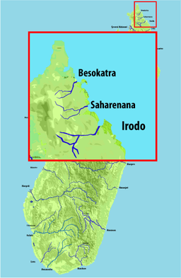
The Besokatra River is located in northern Madagascar.[1] Its sources are situated near Joffreville in the Amber Mountain National Park, in the Ambohitra Massif, it crosses the Route nationale 6 near Mahavanona and flows into the Indian Ocean.
References
- ↑ "Rivers and streams on Madagascar - MADADOC" (PDF). madadoc.irenala.edu.mg. Archived from the original (PDF) on 12 December 2013. Retrieved 6 December 2013.
This article is issued from
Wikipedia.
The text is licensed under Creative Commons - Attribution - Sharealike.
Additional terms may apply for the media files.