Benito Soliven, Isabela
| Benito Soliven | ||
|---|---|---|
| Municipality | ||
| Municipality of Benito Soliven | ||
| ||
 Map of Isabela with Benito Soliven highlighted | ||
.svg.png) Benito Soliven Location within the Philippines | ||
| Coordinates: 16°59′N 121°57′E / 16.98°N 121.95°ECoordinates: 16°59′N 121°57′E / 16.98°N 121.95°E | ||
| Country |
| |
| Region | Cagayan Valley (Region II) | |
| Province | Isabela | |
| District | 2nd District of Isabela | |
| Founded | 1967 | |
| Barangays | 29 (see Barangays) | |
| Government [1] | ||
| • Type | Sangguniang Bayan | |
| • Mayor | Robert Lungan | |
| • Vice Mayor | John Paul Siquian Azur | |
| • Electorate | 15,789 voters (2016) | |
| Area [2] | ||
| • Total | 184.40 km2 (71.20 sq mi) | |
| Population (2015 census)[3] | ||
| • Total | 29,624 | |
| • Density | 160/km2 (420/sq mi) | |
| Time zone | UTC+8 (PST) | |
| ZIP code | 3331 | |
| PSGC | 023104000 | |
| IDD : area code | +63 (0)78 | |
| Climate type | Tropical rainforest climate | |
| Income class | 4th municipal income class | |
| Revenue (₱) | 87,086,135.67 (2016) | |
| Poverty incidence | 23.61 (2012)[4] | |
| Native languages |
Ilocano Tagalog | |
| Website |
www | |

Benito Soliven, officially the Municipality of Benito Soliven, is a 4th class municipality in the province of Isabela, Philippines. According to the 2015 census, it has a population of 29,624 people.[3]
The town is named after the late Benito Soliven, Congressman of Santo Domingo, Ilocos Sur, during the Commonwealth government.
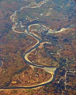
Aerial view of Benito Soliven, with San Mariano in the background
Barangays
Benito Soliven is politically subdivided into 29 barangays. [2]
- Andabuen
- Ara
- Binogtungan
- Capuseran (Capurocan)
- Dagupan
- Danipa
- District II (Poblacion)
- Gomez
- Guilingan
- La Salette
- Makindol
- Maluno Norte
- Maluno Sur
- Nacalma
- New Magsaysay
- District I (Poblacion)
- Punit
- San Carlos
- San Francisco
- Santa Cruz
- Sevillana
- Sinipit
- Lucban
- Villaluz
- Yeban Norte
- Yeban Sur
- Santiago
- Placer
- Balliao
Demographics
| Population census of Benito Soliven | ||
|---|---|---|
| Year | Pop. | ±% p.a. |
| 1970 | 14,850 | — |
| 1975 | 13,475 | −1.93% |
| 1980 | 16,710 | +4.40% |
| 1990 | 20,236 | +1.93% |
| 1995 | 20,685 | +0.41% |
| 2000 | 22,192 | +1.52% |
| 2007 | 25,151 | +1.74% |
| 2010 | 27,337 | +3.08% |
| 2015 | 29,624 | +1.54% |
| Source: Philippine Statistics Authority[3] [5] [6] [7] | ||
In the 2015 census, the population of Benito Soliven was 29,624 people,[3] with a density of 160 inhabitants per square kilometre or 410 inhabitants per square mile.
Climate
| Climate data for Benito Soliven, Isabela | |||||||||||||
|---|---|---|---|---|---|---|---|---|---|---|---|---|---|
| Month | Jan | Feb | Mar | Apr | May | Jun | Jul | Aug | Sep | Oct | Nov | Dec | Year |
| Average high °C (°F) | 29 (84) |
30 (86) |
32 (90) |
35 (95) |
35 (95) |
35 (95) |
34 (93) |
33 (91) |
32 (90) |
31 (88) |
30 (86) |
28 (82) |
32 (90) |
| Average low °C (°F) | 19 (66) |
20 (68) |
21 (70) |
23 (73) |
23 (73) |
24 (75) |
23 (73) |
23 (73) |
23 (73) |
22 (72) |
21 (70) |
20 (68) |
22 (71) |
| Average precipitation mm (inches) | 31.2 (1.228) |
23 (0.91) |
27.7 (1.091) |
28.1 (1.106) |
113.5 (4.469) |
141.4 (5.567) |
176.4 (6.945) |
236.6 (9.315) |
224.9 (8.854) |
247.7 (9.752) |
222.9 (8.776) |
178 (7.01) |
1,651.4 (65.023) |
| Average rainy days | 10 | 6 | 5 | 5 | 13 | 12 | 15 | 15 | 15 | 17 | 16 | 15 | 144 |
| Source: World Weather Online[8] | |||||||||||||
References
- ↑ "Municipality". Quezon City, Philippines: Department of the Interior and Local Government. Retrieved 31 May 2013.
- 1 2 "Province: Isabela". PSGC Interactive. Quezon City, Philippines: Philippine Statistics Authority. Retrieved 12 November 2016.
- 1 2 3 4 Census of Population (2015). "Region II (Cagayan Valley)". Total Population by Province, City, Municipality and Barangay. PSA. Retrieved 20 June 2016.
- ↑ "PSA Releases the 2012 Municipal and City Level Poverty Estimates". Quezon City, Philippines: Philippine Statistics Authority. Archived from the original on 28 January 2017. Retrieved 28 January 2017.
- ↑ Census of Population and Housing (2010). "Region II (Cagayan Valley)". Total Population by Province, City, Municipality and Barangay. NSO. Retrieved 29 June 2016.
- ↑ Censuses of Population (1903–2007). "Region II (Cagayan Valley)". Table 1. Population Enumerated in Various Censuses by Province/Highly Urbanized City: 1903 to 2007. NSO.
- ↑ "Province of Isabela". Municipality Population Data. Local Water Utilities Administration Research Division. Retrieved 17 December 2016.
- ↑ "Benito Soliven, Isabela: Average Temperatures and Rainfall". World Weather Online. Retrieved 31 October 2015.
External links
- Municipal Profile at the National Competitiveness Council of the Philippines
- Benito Soliven at the Isabela Government Website
- Local Governance Performance Management System
- Philippine Standard Geographic Code
- Philippine Census Information
- Municipality of Benito Soliven
Places adjacent to Benito Soliven, Isabela | ||||||||||
|---|---|---|---|---|---|---|---|---|---|---|
| ||||||||||
Ilagan (capital) | |
| Municipalities |
|
| Component Cities | |
| Independent Component City |
|
| Barangays | |
This article is issued from
Wikipedia.
The text is licensed under Creative Commons - Attribution - Sharealike.
Additional terms may apply for the media files.