Bavaria, Kansas
| Bavaria, Kansas | |
|---|---|
| Unincorporated community | |
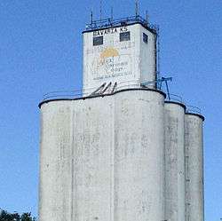 Grain elevator in Bavaria (2015) | |
 Location within Saline County and Kansas | |
 KDOT map of Saline County (legend) | |
| Coordinates: 38°47′50″N 97°45′20″W / 38.79722°N 97.75556°WCoordinates: 38°47′50″N 97°45′20″W / 38.79722°N 97.75556°W[1] | |
| Country | United States |
| State | Kansas |
| County | Saline |
| Township | Ohio |
| Elevation[1] | 1,273 ft (388 m) |
| Time zone | UTC-6 (CST) |
| • Summer (DST) | UTC-5 (CDT) |
| Area code | 785 |
| FIPS code | 20-04575 [1] |
| GNIS feature ID | 0476783 [1] |
Bavaria is an unincorporated community in Saline County, Kansas, United States.[1] It lies along K-140 and a Union Pacific Railroad line west of the city of Salina.
History
The place was originally known as Hohneck, after Ernst Hohneck, who settled there in 1865.[2] It was also known as Honek.[1] Bavaria was laid out by E. F. Drake in 1877, and named after the state of Bavaria, in Germany.[3][4]
Its post office in Bavaria was close in 1986.[5]
Geography
Spring Creek flows through the community.[6]
Demographics
Bavaria a part of Saline County, Bavaria is a part of the Salina micropolitan area.[7]
Education
Bavaria is served by USD 307 Ell-Saline.[8][9][10] Ell-Saline schools are located in Brookville. The Ell-Saline school mascot is Cardinals.
Bavaria schools were closed through school unification. The Bavaria High School mascot was Tigers.[11]
Further reading
References
- 1 2 3 4 5 6 Geographic Names Information System (GNIS) details for Bavaria, Kansas; United States Geological Survey (USGS); October 13, 1978.
- ↑ Blackmar, Frank Wilson (1912). Kansas: A Cyclopedia of State History, Embracing Events, Institutions, Industries, Counties, Cities, Towns, Prominent Persons, Etc. Standard Publishing Company. p. 160.
- ↑ Heim, Michael (2007). Exploring Kansas Highways. p. 37.
- ↑ http://www.kancoll.org/books/cutler/saline/saline-co-p9.html#BAVARIA
- ↑ "Kansas Post Offices, 1828-1961". Kansas Historical Society. Archived from the original on October 9, 2013. Retrieved 23 June 2014.
- ↑ DeLorme. Kansas Atlas & Gazetteer. 4th ed. Yarmouth: DeLorme, 2009, 48. ISBN 0-89933-342-7.
- ↑ Update of Statistical Area Definitions and Guidance on Their Uses Archived 2008-11-17 at the Wayback Machine., Office of Management and Budget, 2007-11-20. Accessed 2008-08-14.
- ↑ USD 307
- ↑ Kansas School District Boundary Map Archived July 21, 2011, at the Wayback Machine.
- ↑ Saline County School District Map Archived July 27, 2011, at the Wayback Machine.
- ↑ "The good ole days", The Salina Journal, 1 December 1994, p.17.
External links
Municipalities and communities of Saline County, Kansas, United States | ||
|---|---|---|
| Cities | 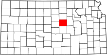 | |
| CDPs | ||
| Unincorporated communities | ||
| Townships |
| |
| Footnotes | ‡This populated place also has portions in an adjacent county or counties | |