Hedville, Kansas
| Hedville, Kansas | |
|---|---|
| Unincorporated community | |
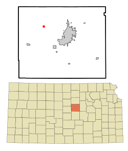 Location within Saline County and Kansas | |
 KDOT map of Saline County (legend) | |
| Coordinates: 38°51′46″N 97°45′41″W / 38.86278°N 97.76139°WCoordinates: 38°51′46″N 97°45′41″W / 38.86278°N 97.76139°W | |
| Country | United States |
| State | Kansas |
| County | Saline |
| Government | |
| • Type | Unincorporated community |
| Elevation | 1,270 ft (390 m) |
| Time zone | UTC-6 (Central Standard Time) |
| • Summer (DST) | UTC-5 (Central Daylight Time) |
| ZIP code | 67401 |
| Area code | 785 |
Hedville is an unincorporated community in northern Ohio Township, Saline County, Kansas, United States. It lies along Hedville Road and a Kansas and Oklahoma Railroad line, 1.0 mile (1.6 km) south of Interstate 70, northwest of the city of Salina, the county seat of Saline County. Mulberry Creek flows through the community.[1] Its elevation is 1,270 feet (387 m), and it is located at 38°51′46″N 97°45′41″W / 38.86278°N 97.76139°W (38.8627816, -97.7614282).[2] As a part of Saline County, Hedville is a part of the Salina micropolitan area.[3]
Education
Primary and secondary education
Hedville is part of Unified School District 307.[4][5][6]
Further reading
References
- ↑ DeLorme. Kansas Atlas & Gazetteer. 4th ed. Yarmouth: DeLorme, 2009, 48. ISBN 0-89933-342-7.
- ↑ U.S. Geological Survey Geographic Names Information System: Hedville, Kansas
- ↑ Update of Statistical Area Definitions and Guidance on Their Uses Archived 2008-11-17 at the Wayback Machine., Office of Management and Budget, 2007-11-20. Accessed 2008-08-14.
- ↑ USD 307
- ↑ Kansas School District Boundary Map Archived 2011-07-21 at the Wayback Machine.
- ↑ Saline County School District Map Archived 2011-07-27 at the Wayback Machine.
External links
| Wikimedia Commons has media related to Hedville, Kansas. |
Municipalities and communities of Saline County, Kansas, United States | ||
|---|---|---|
| Cities | 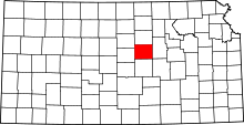 | |
| CDPs | ||
| Unincorporated communities | ||
| Townships |
| |
| Footnotes | ‡This populated place also has portions in an adjacent county or counties | |
This article is issued from
Wikipedia.
The text is licensed under Creative Commons - Attribution - Sharealike.
Additional terms may apply for the media files.