Barren Island (Andaman Islands)
 Barren Island Location of Barren Island | |
| Geography | |
|---|---|
| Location | Bay of Bengal |
| Coordinates | 12°17′N 93°52′E / 12.28°N 93.86°ECoordinates: 12°17′N 93°52′E / 12.28°N 93.86°E |
| Archipelago | Andaman Islands |
| Adjacent bodies of water | Indian Ocean |
| Total islands | 1 |
| Major islands |
|
| Area | 8.34 km2 (3.22 sq mi)[1] |
| Length | 3.4 km (2.11 mi) |
| Width | 3.1 km (1.93 mi) |
| Coastline | 12.38 km (7.693 mi) |
| Highest elevation | 354 m (1,161 ft)[2] |
| Administration | |
| District | North and Middle Andaman |
| Island group | Andaman Islands |
| Island sub-group | East Volcano Islands |
| Taluk | Rangat Taluk |
| Demographics | |
| Population | 0 (2017) |
| Pop. density | 0.00 /km2 (0 /sq mi) |
| Additional information | |
| Time zone | |
| PIN | 744202[3] |
| Telephone code | 031927 [4] |
| ISO code | IN-AN-00[5] |
| Official website |
www |
| Avg. summer temperature | 30.2 °C (86.4 °F) |
| Avg. winter temperature | 23.0 °C (73.4 °F) |
| Census Code | 35.639.0004 |
| Barren Volcano | |
|---|---|
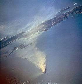 Barren Island erupting in 1995 | |
| Elevation | 353 metres (1,158 ft) |
| Geography | |
| Location | Andaman Islands, India |
| Geology | |
| Mountain type | Stratovolcano with pyroclastic cones |
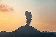
| Last eruption | 2017[6] |
Barren Island is an island located in the Andaman Sea, dominated by Barren Volcano, the only confirmed active volcano in South Asia, and the only active volcano along a chain of volcanoes from Sumatra to Myanmar.[7] Along with the rest of the Andaman Islands, it is a part of the Indian Union Territory of Andaman and Nicobar Islands, and lies about 138 km (86 mi) northeast of the territory's capital, Port Blair.
History

The first recorded eruption of the volcano dates back to 1787. Since then, the volcano has erupted more than ten times, with the most recent one being in 2017.[8] After the first recorded eruption in 1787, further eruptions were recorded in 1789, 1795, 1803–04, and 1852. After nearly one and half century of dormancy, the island had another eruption in 1991 that lasted six months and caused considerable damage.[9][10]
The 1991 eruption was particularly harmful to the island's fauna. A team from the Geological Survey of India visited Barren Island on 8–9 April 1993 to access the impact of the eruption on the distribution, habit, and abundance of animal species. The report found that the eruption had reduced the number of bird species and their population. The team only observed 6 of the 16 known species of birds on the island. The Pied Imperial Pigeon (Ducula bicolor) was the most abundant among the 6 species observed. In a survey conducted at night, the team spotted one rat species (Rattus rattus) and 51 species of insects from eight orders. The report also noted that the volcano was still emitting gas at the time.[7] There were eruptions in 1994–95 and 2005–07, the latter considered to be linked to the 2004 Indian Ocean earthquake.[9] A Lighthouse that was established on 1993 was destroyed by the recent eruptions.[11]
A team from the National Institute of Oceanography (NIO) spotted the volcano erupting on 23 January 2017. Abhay Mudholkar, the head of the team, said, "The volcano is erupting in small episodes of about five to ten minutes. During the day, only ash clouds were observed. However, after sundown, red lava fountains were spewing from the crater into the atmosphere and hot lava flowed streaming down its slopes."[12][13][14]
Based on Ar-Ar dating of samples from Barren Island it is now established that the oldest subaerial lava flows of the volcano is 1.6 million year old and the volcano is located on an oceanic crust which is ~106 million year old.[15] All recorded eruptions lie on the low end of the Volcanic Explosivity Index. The 2017 eruption was recorded as a 2 on the index.[7]
Geography
This volcanic island stands in the midst of a volcanic belt on the edge of the Indian and Burmese tectonic plates. Narcondam Island is a dormant volcano in the area, apart from volcanic seamounts like Alcock and Sewell. All the historical and recent eruptions (1789 and after) are confined within and around an active polygenetic cinder cone in a 2 km (1.2 mi) wide caldera that was formed by the Pleistocene collapse of a primitive cone of a stratovolcano. The remnant of the primitive volcanic cone forms a precipitous cliff around the island (commonly referred as caldera wall), with a break towards the west. The highest elevation on the island is 354 m (1,161 ft), with most of the primitive volcano underwater (standing on the seafloor 2,250 metres (7,380 ft) below sea level). The island is 3 km (1.9 mi) in diameter, with a total surface area of 8.34 km2 (3.22 sq mi).[16]
Biodiversity
True to its name, it has a barren landscape uninhabited by humans, though it has a small population of goats.[17] Also birds, bats like flying foxes and a few rodent species such as rats are known to survive the harsh conditions.[18]
The island is devoid of any significant vegetation.[7]
Tourism
The waters surrounding Barren Island are reputed to be among the world's top scuba diving destinations. Major attractions here are the crystal clear visibility, Manta Rays, interesting basalt formations, topography of past lava flows and fast growing coral gardens. This dive destination is remote but can be accessed by either a live aboard ship or with scuba-operators based at Havelock Island.[19][20]
Administration
It belongs to the North and Middle Andaman administrative district, part of the Indian union territory of Andaman and Nicobar Islands.[21]
Demographics
The island is uninhabited as of 2017.
Image gallery
 Barren Island erupts
 Outline map of the Andaman Islands, with the location of Barren Island highlighted (red circle)
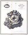 Topography of the island
See also
References
- ↑ "Islandwise Area and Population - 2011 Census" (PDF). Government of Andaman.
- ↑ pro star
- ↑ "A&N Islands - Pincodes". 2016-09-22. Archived from the original on 2014-03-23. Retrieved 2016-09-22.
- ↑ code
- ↑ Registration Plate Numbers added to ISO Code
- ↑ "Barren Island volcano". 19 Feb 2018.
- 1 2 3 4 Koshy, Jacob. "Why did Barren Island volcano erupt again?". The Hindu. Retrieved 26 February 2017.
- ↑ "Barren Island". Global Volcanism Program. Smithsonian Institution.
- 1 2 Jørgen S. Aabech. "Barren Island, Andaman Islands, Indian Ocean". Retrieved 2013-06-01.
- ↑ Mallet, F.R. (1895). "Bibliography of Barren Island and Narcondam, from 1884 to 1894". Records of the Geological Survey of India. 28: 34–38.
- ↑
- ↑ "NIO finds Andaman volcano spewing lava - Times of India". The Times of India. Retrieved 18 February 2017.
- ↑ "India's only live volcano active again: National Institute of Oceanography". The Indian Express. 18 February 2017. Retrieved 18 February 2017.
- ↑ "Barren Island volcano, India's only live volcano, became active in January". hindustantimes.com/. 18 February 2017. Retrieved 18 February 2017.
- ↑ Ray et al., Bull Volcanol 77: 57, 2015
- ↑ "Barren Island Volcano, Indian Ocean - facts & information". Volcanodiscovery.com. Retrieved 2013-06-01.
- ↑ Barren goats
- ↑ "Scientific Expedition to Barren Island (Andaman Islands, Indian Ocean)". 2003. Archived from the original on 2 April 2012. Retrieved 2013-06-01.
- ↑ Miranda Krestovnikoff; Monty Halls (17 July 2006). Scuba Diving. DK Publishing. pp. 275–. ISBN 978-0-7566-4063-7.
- ↑ https://timesofindia.indiatimes.com/india/Scuba-dive-at-an-active-volcano-on-Barren-Island-in-Andamans/articleshow/25837581.cms
- ↑ "Village Code Directory: Andaman & Nicobar Islands" (PDF). Census of India. Retrieved January 16, 2011.
External links
| Wikimedia Commons has media related to Barren Island (Andaman Islands). |
| Wikisource has the text of the 1911 Encyclopædia Britannica article Barren Island. |
- Geological Survey of India : THE BARREN ISLAND VOLCANO
- Department of Earth Sciences, IIT Bombay
- Bhaumik, Subir (11 July 2005). "Andamans volcano is post-tsunami hit". BBC News. Retrieved 2013-06-01.
- Geological Survey of India
