Hailuoto
| Hailuoto Hailuoto — Karlö | ||
|---|---|---|
| Municipality | ||
|
Hailuodon kunta Karlö kommun | ||
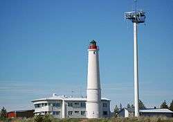 Pilot station and lighthouse in Marjaniemi | ||
| ||
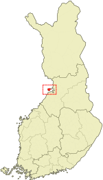 Location of Hailuoto in Finland | ||
| Coordinates: 65°01′N 024°43′E / 65.017°N 24.717°ECoordinates: 65°01′N 024°43′E / 65.017°N 24.717°E | ||
| Country |
| |
| Region | Northern Ostrobothnia | |
| Sub-region | Oulu sub-region | |
| Government | ||
| • Municipal manager | Ari Nurkkala | |
| Area (2018-01-01)[1] | ||
| • Total | 1,082.70 km2 (418.03 sq mi) | |
| • Land | 200.53 km2 (77.43 sq mi) | |
| • Water | 882.17 km2 (340.61 sq mi) | |
| Area rank | 261st largest in Finland | |
| Population (2017-08-31)[2] | ||
| • Total | 981 | |
| • Rank | 300th largest in Finland | |
| • Density | 4.89/km2 (12.7/sq mi) | |
| Population by native language[3] | ||
| • Finnish | 99.1% (official) | |
| • Swedish | 0.1% | |
| • Others | 0.8% | |
| Population by age[4] | ||
| • 0 to 14 | 13.9% | |
| • 15 to 64 | 61.5% | |
| • 65 or older | 24.6% | |
| Time zone | UTC+2 (EET) | |
| • Summer (DST) | UTC+3 (EEST) | |
| Municipal tax rate[5] | 19.25% | |
| Website | www.hailuoto.fi | |
| Official name | Bird Wetlands of Hailuoto Island | |
| Designated | 2 February 2004 | |
| Reference no. | 1505[6] | |

Hailuoto (Swedish: Karlö) is an island and a municipality in Northern Ostrobothnia region, Finland. The population of Hailuoto is 981 (August 31, 2017)[2] and the municipality covers an area of 200.53 km2 (77.43 sq mi) (excluding sea areas) of which 1.70 km2 (0.66 sq mi) is inland water (January 1, 2018).[1] The population density is 4.89/km2 (12.7/sq mi).
Hailuoto is located on an island of the same name opposite the city of Oulu in the Gulf of Bothnia. A ferry operates regularly between Hailuoto and Oulunsalo. In winter an official ice road connects the island to the mainland.
Land in the region is constantly rising due to post-glacial rebound. It is estimated that the first parts of Hailuoto appeared from the Baltic Sea about 1700 years ago. The current island of Hailuoto was formed from many smaller islands. Two large sections, Santonen and Hanhinen merged into the main island (Luoto) only about two centuries ago. The island is continuously expanding and eventually it will join with the continent. Kirkkosalmi, a wetland region between Hanhinen and Luoto is renowned for being an important bird refuge where rare bird species are observed.
Gallery
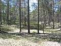 Typical forest in Hailuoto
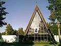 Hailuoto Church, built in 1972
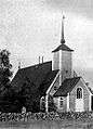 Old church, built in the 1610s, destroyed by fire in 1968
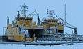 The ferries Meriluoto and Merisilta
 The ice road between the island and the mainland
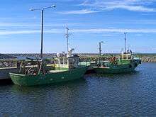 Fishing boats in Marjaniemi
See also
References
- 1 2 "Area of Finnish Municipalities 1.1.2018" (PDF). National Land Survey of Finland. Retrieved 30 January 2018.
- 1 2 "Ennakkoväkiluku sukupuolen mukaan alueittain, elokuu 2017" (in Finnish). Statistics Finland. Retrieved 18 October 2017.
- ↑ "Population according to language and the number of foreigners and land area km2 by area as of 31 December 2008". Statistics Finland's PX-Web databases. Statistics Finland. Retrieved 29 March 2009.
- ↑ "Population according to age and gender by area as of 31 December 2008". Statistics Finland's PX-Web databases. Statistics Finland. Retrieved 28 April 2009.
- ↑ "List of municipal and parish tax rates in 2011". Tax Administration of Finland. 29 November 2010. Retrieved 13 March 2011.
- ↑ "Bird Wetlands of Hailuoto Island". Ramsar Sites Information Service. Retrieved 25 April 2018.
External links

- hailuototourism.fi
- Municipality of Hailuoto – Official site (in Finnish)

- Ferry timetables (in Finnish)
- Bothnian Bay Research Station of the University of Oulu
- Live webcam from the ferry
| Municipalities |  | |
|---|---|---|
| Former | ||