Haukipudas
| Haukipudas | ||
|---|---|---|
| Municipality | ||
| Haukiputaan kunta | ||
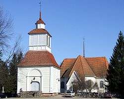 The church and the belfry of Haukipudas | ||
| ||
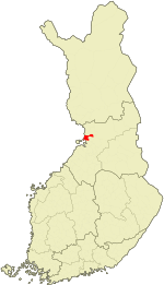 Location of Haukipudas in Finland | ||
| Coordinates: 65°11′N 025°21′E / 65.183°N 25.350°ECoordinates: 65°11′N 025°21′E / 65.183°N 25.350°E | ||
| Country | Finland | |
| Region | Northern Ostrobothnia | |
| Sub-region | Oulu sub-region | |
| Charter | 1866 | |
| Government | ||
| • Municipality manager | Jarmo Ronkainen | |
| Area[1] | ||
| • Total | 1,023.62 km2 (395.22 sq mi) | |
| • Land | 798.67 km2 (308.37 sq mi) | |
| • Water | 224.95 km2 (86.85 sq mi) | |
| Population (2012)[2] | ||
| • Total | 19,053 | |
| • Density | 23.86/km2 (61.8/sq mi) | |
| Time zone | UTC+2 (EET) | |
| • Summer (DST) | UTC+3 (EEST) | |
| Website | www.haukipudas.fi | |

Haukipudas is a town and former municipality of Finland. It is located in the province of Oulu and part of the Northern Ostrobothnia region. Its shore runs along the Gulf of Bothnia, with the river Kiiminkijoki running through the province. Along with Kiiminki, Oulunsalo and Yli-Ii municipalities it was merged with the city of Oulu on 1 January 2013.
The municipality had a population of 19,053 (31 December 2012)[2] and covered an area of 1,023.62 km2 (395.22 sq mi) of which 224.95 km2 (86.85 sq mi) is water.[1] The population density is 23.8559/km2 (61.7865/sq mi).
The municipality was unilingually Finnish.[3]
There were 16 villages in Haukipudas: Kirkonkylä, Santaholma, Ukonkaivos, Martinniemi, Asemakylä, Onkamo, Halosenniemi, Holstinmäki, Häyrysenniemi, Jokikylä, Kalimeenkylä, Kello, Kiviniemi, Parkumäki, Takkuranta and Virpiniemi.
The educational department took part in Lifelong Learning Programme 2007–2013 in Finland.
Local sights
- The Haukipudas Church, built in 1762.
- Kiviniemi, a fishing village
- Virpiniemi
- Kurtinhaudan beach-forest
- Halosenniemi
- Haukiputaan homestead
Islands located off the Gulf of Bothnia
The following is a compilation of some of the islands of Haukipudas located just off the coast of the Gulf of Bothnia:
Hanhikari, Hietakari, Hoikka-Hiue, Iso-Hiue, Iso-Miehikkä, Isonkivenletto, Kaasamatala (Hiuvet), Kattilankalla, Kellon Kraaseli, Kintasletto, Kotakari, Kriisinkivi, Kropsu, Laitakari, Lemmonletto, Länsiletto, Lönkytin, Mustakari, Mustakari (Martinniemi), Nimetön, Pallonen, Pensaskari, Pikku-Miehikkä, Pulkkisenmatala, Puukkoletto, Rapakari, Rivinletto (Kaasamatala), Santapankki, Satakarinletto, Ulko-Pallonen, Välikari, Ykskivi, Väliletto, Äijänkumpele.
Notable individuals
- Päivi Alasalmi, writer
- Veikko Enckell, pop lyricist
- Matti Hannus, sports writer
- Tytti Isohookana-Asunmaa, Minister and Member of Parliament (Centre Party)
- Osmo Jussila, political historian
- Juhani Laitala, actor
- Merja Larivaara, actor
- Lea Laven, entertainer and singer
- Hjalmar Lindqvist, Member of Parliament (Social Democratic Party)
- Yrjö Murto, Minister and Member of Parliament (Finnish People's Democratic League)
- Miika Nousiainen, writer
- Sakari Pietilä, ice hockey player
- Lasse Pirjetä, ice hockey player
- Samuli Pohjamo, Member of the European Parliament
- Jukka Poika, singer
- Jukka Rasila, actor
- Riitta-Liisa Roponen, cross-country skier
- Joni Skiftesvik, writer
- Jukka Takalo, singer
- Eero Tapio, Olympic wrestler
- Mirja Vehkaperä, Member of Parliament (Centre Party)
Haukipudas photo gallery
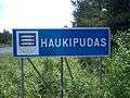 Municipal border sign
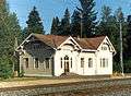 Haukipudas railway station
 Kiiminki River railway bridge
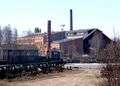 Martinniemi sawmill
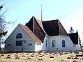 Haukipudas Church
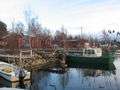 Kiviniemi fishing village
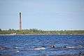 Island of Laitakari
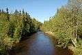 Kalimeenoja creek
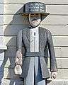 The wooden poorboy (vaivaisukko in Finnish) by the Belfry of Haukipudas Church.
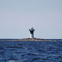
 Kurtinhauta fishing harbour
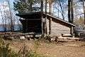 Finnish 'laavu'
References
- 1 2 "Area by municipality as of 1 January 2011" (PDF) (in Finnish and Swedish). Land Survey of Finland. Retrieved 9 March 2011.
- 1 2 "VÄESTÖTIETOJÄRJESTELMÄ REKISTERITILANNE 31.1.2012" (in Finnish and Swedish). Population Register Center of Finland. Archived from the original on 3 October 2013. Retrieved 11 February 2014.
- ↑ "Population according to language and the number of foreigners and land area km2 by area as of 31 December 2008". Statistics Finland's PX-Web databases. Statistics Finland. Retrieved 29 March 2009.
External links

- Municipality of Haukipudas – Official website
| Municipalities |  | |
|---|---|---|
| Former | ||