Áta
| Áta | ||
|---|---|---|
| ||
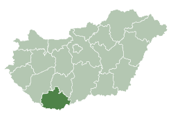
 Location of Baranya county in Hungary | ||
 Áta Location of Áta | ||
| Coordinates: 45°56′11″N 18°17′55″E / 45.93631°N 18.29849°ECoordinates: 45°56′11″N 18°17′55″E / 45.93631°N 18.29849°E | ||
| Country |
| |
| County | Baranya | |
| Area | ||
| • Total | 8.09 km2 (3.12 sq mi) | |
| Population (2015) | ||
| • Total | 165 | |
| • Density | 20/km2 (53/sq mi) | |
| Time zone | UTC+1 (CET) | |
| • Summer (DST) | UTC+2 (CEST) | |
| Postal code | 7763 | |
| Area code(s) | 72 | |

Áta (Croatian: Ata) is a village in Baranya county, Hungary.
Etymology
Áta is a Turkish name which means father. Áta is also used in Atatürk's name.
History
Áta has been inhabited since ancient times. Before the Hungarian tribes conquered the area, it was inhabited by Slav people. In 1526 the county was occupied by Ottomans, and was freed in 1689.
External links
- Street map (in Hungarian)
| Look up Ata in Wiktionary, the free dictionary. |
This article is issued from
Wikipedia.
The text is licensed under Creative Commons - Attribution - Sharealike.
Additional terms may apply for the media files.