Ban Pho District
| Ban Pho บ้านโพธิ์ | |
|---|---|
| Amphoe | |
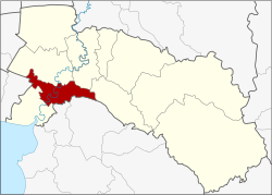 Amphoe location in Chachoengsao Province | |
| Coordinates: 13°35′59″N 101°4′43″E / 13.59972°N 101.07861°ECoordinates: 13°35′59″N 101°4′43″E / 13.59972°N 101.07861°E | |
| Country |
|
| Province | Chachoengsao |
| Area | |
| • Total | 217.593 km2 (84.013 sq mi) |
| Population (2017) | |
| • Total | 52,525 |
| • Density | 241.39/km2 (625.2/sq mi) |
| Time zone | UTC+7 (THA) |
| Postal code | 24140 |
| Geocode | 2405 |
Ban Pho (Thai: บ้านโพธิ์, pronounced [bâːn pʰōː]) is a district (amphoe) in the western part of Chachoengsao Province, central Thailand.
History
The district was established by separate a part of Mueang Chachoengsao district in 1903, then named Sanam Chan (สนามจันทร์) by Prince Marubhongse Siribhadhana, the governor of Monthon Prachinburi.[1] In the past Tambon Sanam Chan area was on the both banks of the Bang Pakong River, around 1906 the government split the area on the left bank where the district office was located, to create Tambon Ban Pho.
Later when King Vajiravudh (Rama VI) built the Sanam Chan Palace in Nakhon Pathom in 1911, as the district name was pronounced same as the Sanam Chan Palace, the government changed the district name to be Khao Din district on July 20, 1914.[2] Later they changed to be Ban Pho district in 1917.
Geography
Neighboring districts are (from the north clockwise) Mueang Chachoengsao, Bang Khla, Plaeng Yao of Chachoengsao Province, Phanat Nikhom, Phan Thong of Chon Buri Province, Bang Pakong of Chachoengsao Province again and Bang Bo of Samut Prakan Province.
The important water resource is the Bang Pakong River.
Administration
Central administration
The district Ban Pho is subdivided into 17 subdistrict (Tambon), which are further subdivided into 73 administrative villages (Muban).
| No. | Name | Thai | Villages | Pop.[3] |
|---|---|---|---|---|
| 1. | Ban Pho | บ้านโพธิ์ | 4 | 2,886 |
| 2. | Ko Rai | เกาะไร่ | 5 | 4,473 |
| 3. | Khlong Khut | คลองขุด | 4 | 2,258 |
| 4. | Khlong Ban Pho | คลองบ้านโพธิ์ | 4 | 1,950 |
| 5. | Khlong Prawet | คลองประเวศ | 3 | 3,430 |
| 6. | Don Sai | ดอนทราย | 4 | 3,008 |
| 7. | Theppharat | เทพราช | 6 | 6,121 |
| 8. | Tha Phlap | ท่าพลับ | 4 | 1,297 |
| 9. | Nong Tin Nok | หนองตีนนก | 5 | 3,012 |
| 10. | Nong Bua | หนองบัว | 4 | 2,324 |
| 11. | Bang Son | บางซ่อน | 3 | 1,447 |
| 12. | Bang Krut | บางกรูด | 3 | 1,970 |
| 13. | Laem Pradu | แหลมประดู่ | 6 | 3,431 |
| 14. | Lat Khwang | ลาดขวาง | 4 | 4,153 |
| 15. | Sanam Chan | สนามจันทร์ | 6 | 2,337 |
| 16. | Saen Phu Dat | แสนภูดาษ | 3 | 4,492 |
| 17. | Sip Et Sok | สิบเอ็ดศอก | 5 | 3,936 |
Local administration
There are 4 subdistrict municipalities (Thesaban Tambon) in the district:
- Lat Khwang (Thai: เทศบาลตำบลลาดขวาง) consisting of the complete subdistrict Lat Khwang.
- Saen Phu Dat (Thai: เทศบาลตำบลแสนภูดาษ) consisting of the complete subdistrict Saen Phu Dat.
- Theppharat (Thai: เทศบาลตำบลเทพราช) consisting of parts of the subdistricts Ko Rai, Theppharat.
- Ban Pho (Thai: เทศบาลตำบลบ้านโพธิ์) consisting of the complete subdistrict Ban Pho.
There are 12 subdistrict administrative organizations (SAO) in the district:
- Ko Rai (Thai: องค์การบริหารส่วนตำบลเกาะไร่) consisting of parts of the subdistrict Ko Rai.
- Khlong Khut (Thai: องค์การบริหารส่วนตำบลคลองขุด) consisting of the complete subdistrict Khlong Khut.
- Khlong Ban Pho (Thai: องค์การบริหารส่วนตำบลคลองบ้านโพธิ์) consisting of the complete subdistrict Khlong Ban Pho, Bang Son.
- Khlong Prawet (Thai: องค์การบริหารส่วนตำบลคลองประเวศ) consisting of the complete subdistrict Khlong Prawet.
- Don Sai (Thai: องค์การบริหารส่วนตำบลดอนทราย) consisting of the complete subdistrict Don Sai.
- Theppharat (Thai: องค์การบริหารส่วนตำบลเทพราช) consisting of parts of the subdistrict Theppharat.
- Nong Tin Nok (Thai: องค์การบริหารส่วนตำบลหนองตีนนก) consisting of the complete subdistrict Nong Tin Nok.
- Nong Bua (Thai: องค์การบริหารส่วนตำบลหนองบัว) consisting of the complete subdistrict Tha Phlap, Nong Bua.
- Bang Krut (Thai: องค์การบริหารส่วนตำบลบางกรูด) consisting of the complete subdistrict Bang Krut.
- Laem Pradu (Thai: องค์การบริหารส่วนตำบลแหลมประดู่) consisting of the complete subdistrict Laem Pradu.
- Sanam Chan (Thai: องค์การบริหารส่วนตำบลสนามจันทร์) consisting of the complete subdistrict Sanam Chan.
- Sip Et Sok (Thai: องค์การบริหารส่วนตำบลสิบเอ็ดศอก) consisting of the complete subdistrict Sip Et Sok.
References
- ↑ แจ้งความกระทรวงมหาดไทย เรื่อง ตั้งอำเภอสนามจันทร์ เมืองฉะเชิงเทราขึ้นอีกอำเภอหนึ่ง และยกเลิกอำเภอหัวไทร เมืองฉะเชิงเทรา [Inform the Ministry of Interior that the district court Monday. Another district in Chachoengsao. And Hua Sai district canceled. Chachoengsao.] (PDF). Royal Gazette (in Thai). 20 (49): 833. March 6, 1903.
- ↑ ประกาศกระทรวงมหาดไทย ประกาศเปลี่ยนชื่ออำเภอ [Ministry of the Interior. Change name of the district.] (PDF). Royal Gazette (in Thai). 31 (0 ง): 928–931. July 26, 1914.
อำเภอพะชะนะ เป็น อำเภอด่านขุนทด อำเภอท่าบ่อ เป็นอำเภอเมืองพานพร้าว และอำเภอสนามจันทร์ เป็นอำเภอเขาดิน โดยมีการกล่าวถึงวิธีขนานนามอำเภอมาแต่โบราณให้ศึกษาด้วย
- ↑ "Population statistics 2017" (in Thai). Department of Provincial Administration. Retrieved 2018-04-04.
External links
- Ban Pho district history(Thai)