Bang Pakong River
| Bang Pakong River | |
|---|---|
 | |
| Native name | แม่น้ำบางปะกง |
| Country | Thailand |
| Physical characteristics | |
| Main source | 14°00′03″N 101°08′19″E / 14.00083°N 101.13861°E |
| Basin features | |
| Basin size | 17,000 km2 (6,600 sq mi) |
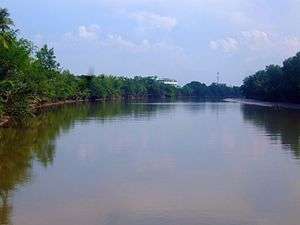
The Bang Pakong (Thai: แม่น้ำบางปะกง, RTGS: Maenam Bang Pakong, pronounced [mɛ̂ː.náːm bāːŋ pā.kōŋ]) is a river in east Thailand. The river originates at the confluence of the Nakhon Nayok River and the Prachinburi River at Pak Nam Yothaka in Ban Sang District, Prachinburi Province. It empties into the Gulf of Thailand in the northeastern tip of the Bay of Bangkok. The watershed of the Bang Pa Kong is about 17,000 square kilometres (6,600 sq mi). It also powers a big power station near its mouth, near highway 7.
To protect the Irrawaddy dolphins, many fishermen on the Bang Pakong River have been persuaded by authorities to stop shrimping and 30 to 40 fishing boats have been modified so they can offer dolphin sightseeing tours.[1]
Dvaravati settlements include Muang Phra Rot, Dong Si Maha Pht, Dong Lakhon, and Ban Khu Muang. Dvaravati coins have been found at U Taphao.[2]:302,309
Tributaries
References
| Wikimedia Commons has media related to Bang Pakong River. |
- ↑ Svasti, Pichaya (2007-03-24). "The Irrawaddy dolphin". Bangkok Post. Reprinted by ASEAN Biodiversity. Retrieved 2008-12-30.
- ↑ Higham, C., 2014, Early Mainland Southeast Asia. Bangkok: River Books Co., Ltd., ISBN 9786167339443
Coordinates: 13°26′50″N 100°56′53″E / 13.4471°N 100.948°E