Ban Dung District
| Ban Dung บ้านดุง | |
|---|---|
| Amphoe | |
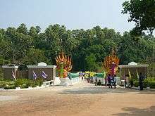
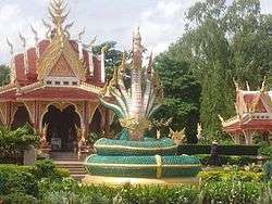 Shrine in Sri Sut Tho | |
 Amphoe location in Udon Thani Province | |
| Coordinates: 17°42′4″N 103°15′35″E / 17.70111°N 103.25972°ECoordinates: 17°42′4″N 103°15′35″E / 17.70111°N 103.25972°E | |
| Country | Thailand |
| Province | Udon Thani |
| Tambon | 13 |
| Muban | 159 |
| Amphoe established | 1959 |
| Government | |
| • District head officer | Paitoon Chitsuttipon (นายไพฑูรย์ จิตต์สุทธิผล ) |
| Area | |
| • Total | 923.768 km2 (356.669 sq mi) |
| Population (2013) | |
| • Total | 124,812 |
| • Density | 133.2/km2 (345/sq mi) |
| Time zone | UTC+7 (ICT) |
| Postal code | 41190 |
| Geocode | 4111 |
Ban Dung (Thai: บ้านดุง, pronounced [bâːn dūŋ]) is a district (amphoe) in northeastern Udon Thani Province, Isan, Thailand.
Geography
Neighboring districts are (from the south clockwise) Thung Fon, Phibun Rak, Phen, and Sang Khom of Udon Thani Province, Phon Phisai and Fao Rai of Nong Khai Province, and Ban Muang, Charoen Sin, and Sawang Daen Din of Sakon Nakhon Province.
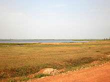
North of Ban Dung are marshlands and open water called Nong Pla Tao.
The major river is the Songkhram, which marks the boundary of the district to the east.
History
The minor district (king amphoe) Ban Dung was established on 16 May 1959, when three sub-districts were split off from Nong Han district.[1] It was upgraded to a full district on 16 July 1963.[2]
Administration
Central administration
Ban Dung is divided into 13 sub-districts (tambon), which are further divided into 159 administrative villages (muban).[3]
| No. | Name | Thai | Villages | Pop.[4] |
|---|---|---|---|---|
| 1. | Si Suttho | ศรีสุทโธ | 12 | 14,571 |
| 2. | Ban Dung | บ้านดุง | 18 | 13,756 |
| 3. | Dong Yen | ดงเย็น | 8 | 6,720 |
| 4. | Phon Sung | โพนสูง | 17 | 11,160 |
| 5. | Om Ko | อ้อมกอ | 10 | 8,568 |
| 6. | Ban Chan | บ้านจันทน์ | 18 | 14,277 |
| 7. | Ban Chai | บ้านชัย | 9 | 8,615 |
| 8. | Na Mai | นาไหม | 13 | 10,232 |
| 9. | Thon Na Lap | ถ่อนนาลับ | 8 | 5,272 |
| 10. | Wang Thong | วังทอง | 9 | 6,252 |
| 11. | Ban Muang | บ้านม่วง | 14 | 8,584 |
| 12. | Ban Tat | บ้านตาด | 10 | 6,987 |
| 13. | Na Kham | นาคำ | 13 | 9,818 |
Local administration
There is one town (thesaban mueang) in the district:
- Ban Dung (Thai: เทศบาลเมืองบ้านดุง) consisting of sub-district Si Suttho and parts of sub-district Ban Dung. The town is divided into 34 communities (chumchon).
There are 12 sub-district administrative organizations (SAO) in the district:
- Ban Dung (Thai: องค์การบริหารส่วนตำบลบ้านดุง) consisting of parts of sub-district Ban Dung.
- Dong Yen (Thai: องค์การบริหารส่วนตำบลดงเย็น) consisting of sub-district Dong Yen.
- Phon Sung (Thai: องค์การบริหารส่วนตำบลโพนสูง) consisting of sub-district Phon Sung.
- Om Ko (Thai: องค์การบริหารส่วนตำบลอ้อมกอ) consisting of sub-district Om Ko.
- Ban Chan (Thai: องค์การบริหารส่วนตำบลบ้านจันทน์) consisting of sub-district Ban Chan.
- Ban Chai (Thai: องค์การบริหารส่วนตำบลบ้านชัย) consisting of sub-district Ban Chai.
- Na Mai (Thai: องค์การบริหารส่วนตำบลนาไหม) consisting of sub-district Na Mai.
- Thon Na Lap (Thai: องค์การบริหารส่วนตำบลถ่อนนาลับ) consisting of sub-district Thon Na Lap.
- Wang Thong (Thai: องค์การบริหารส่วนตำบลวังทอง) consisting of sub-district Wang Thong.
- Ban Muang (Thai: องค์การบริหารส่วนตำบลบ้านม่วง) consisting of sub-district Ban Muang.
- Ban Tat (Thai: องค์การบริหารส่วนตำบลบ้านตาด) consisting of sub-district Ban Tat.
- Na Kham (Thai: องค์การบริหารส่วนตำบลนาคำ) consisting of sub-district Na Kham.
Economy
The district is the site of a Voice of America (VOA) relay station. The Voice of America will give the station to Thailand, but will be allowed to operate it under a 25-year renewable lease. Each of the station's seven shortwave transmitters is capable of broadcasting 500 kilowatts of power, covering 40 percent of the earth's surface. One of the transmitters will be dedicated for use by Radio Thailand. It will have sufficient power to reach the Middle East and the West Coast of the United States, both areas with large expatriate Thai communities.[5]
The VOA installation has been suspected of being a CIA black site used to interrogate alleged terrorists.[6][7] That suspicion has been supplanted by a BBC report that the Udon Royal Air Force Base was the home of a CIA black site, known to insiders as "Cat's Eye", but better known as "Detention Site Green",[8] used to interrogate Abu Zubaydah, a 31-year-old Saudi-born Palestinian, believed to be one of Osama Bin Laden's top lieutenants. In December 2014 the United States Senate Select Committee on Intelligence (SSCI) published an executive summary of a secret 6,000 page report on CIA techniques. The report alleges that at least eight Thai senior officials knew of the secret site. The site was closed in December 2002.[9] Thailand has denied the existence of the site while the US government has neither confirmed or denied its existence.
Farming
The major crop grown is rice with 259,066 rai being cultivated by 13,708 people out of a total farming area of 327,480 rai. There was also 15,667 rai of rubber under cultivation, 550 rai of palm oil, and 1,445 rai used for rock salt extraction. Other crops included maize, cassava, eucalyptus, sugar cane and various fruit and vegetables. Other farming activities included the rearing of buffalo, cattle, pigs, and chickens with a small number of people raising fish in lakes or ponds.
The average income per year in Ban Dung was 42,023 baht per person in 2011 with the majority of people being farmers. However, there is an increasing number of people employed in the retail and building trades as the town continues to increase in size with a steady influx of people moving into Ban Dung including a significant number of expats and their spouses.
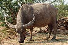
Water buffalo are a regular feature being walked to and from the fields at dawn and dusk. Although rarely used nowadays for working the land, they are considered an important status symbol.
Salt production
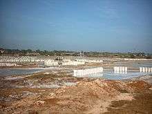
The salt making area around Ban Dung has produced salt for industrial purposes for more than 25 years. The production method used as in many other places in northeast Thailand is called solution mining. The mining is done by local co-operative groups.
Refined salt for domestic use is made by evaporating salt water in large open vats using ovens with rice husks used as the fuel source. This method produces very clean, fine grained salt in which the impurities are removed during cooking. Traditionally, the stove used in salt making was wood-fueled. Wood became more expensive, prompting a shift to rice hull stoves. The abundance of rice hulls has made it economically feasible to reprocess the salt and is a renewable source of fuel. The residue, rice hull ash, (RHA) is then sold back to farmers for use as fertilizer.
Places of interest
- Wat Kham Chanot: Approximately 10 km from Ban Dung, Wat Kham Chanot is said to be an entrance to the water world, a legendary place where the Naga, a mythical large snake often suggested to have seven heads, is supposed to live. Covering an area of over 20 rai of land, it is nothing but an islet surrounded by water with dense palm trees called "chanot".
- The City Pillar Shrine in tambon Sri Sut Tho: A symbol of the amphoe.
- Pagoda and temple at Ban Lao Luang: The pagoda and temple host relics of Buddha brought from India on 1 May 2000.
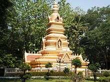
- Pagoda at Ban Dong Sawan: The bones and possessions of Ajahn Luang Pu reside here and is a sacred place for many Buddhists.
- Voice of America: The Voice of America headquarters for Southeast Asia is three kilometres out of Ban Dung on Highway 2022. Many 500 kW shortwave transmitters are installed here. Call sign: Udon Thani.
Transportation
The town is adjacent to the intersection of Highway 2022 and Highway 2096.
Buses
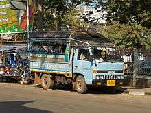
Essential local services are provided by songthaew truck and pickup truck buses, while regional and long distance destinations are served by regular buses from Udon Thani.
There are two main public buses. Both start at the central bus station in Udon Thani. One bus route goes via Highway 22 and then turns left at Nong Mek along Highway 2096 to Ban Dung (Kham Takla bus route). The other bus route goes via Highway 2 before turning right at Ban Na Kha along Highway 2256 to the Sum Sao intersection and then along Highway 2022 to Ban Dung (Bueng Kan Bus route). Both run at regular intervals.
Long-distance VIP buses operate from opposite the police station and run nightly to Bangkok. There are also direct night buses to and from Pattaya.
References
- ↑ ประกาศกระทรวงมหาดไทย เรื่อง ยกฐานะตำบลขึ้นเป็นกิ่งอำเภอ (PDF). Royal Gazette (in Thai). 76 (53 ง): 1368–1369. 1959-05-19.
- ↑ พระราชกฤษฎีกาตั้งอำเภอบ่อพลอย อำเภอไทรโยค อำเภอหนองเรือ อำเภอหนองสองห้อง อำเภอประทาย อำเภอห้วยแถลง อำเภอละหานทราย อำเภอกุยบุรี อำเภอตาพระยา อำเภอหนองไผ่ อำเภอนาเชือก อำเภอวัดเพลง อำเภอพนัสนิคม อำเภอภูกระดึง อำเภอปรางค์กู่ อำเภอท่าช้าง อำเภอบ้านด่านลานหอย อำเภอบ้านดง อำเภอสว่างอารมณ์ และอำเภอกุดชุม พ.ศ. ๒๕๐๖ (PDF). Royal Gazette (in Thai). 80 (72 ก): 362. 1963-07-16.
- ↑ "Bandung Administrative website". Archived from the original on 2015-11-01. Retrieved 2016-02-05.
- ↑ "Population statistics 2013" (in Thai). Department of Provincial Administration. Retrieved 2014-12-18.
- ↑ "New station in Thailand to boost VOA". UPI. 1994-06-02. Retrieved 27 April 2018.
- ↑ Crispin, Shawn W (2008-01-25). "US and Thailand: Allies in Torture". Asia Times. Retrieved 2014-11-10.
- ↑ "Suspicion over Thai 'black ops' site". Sydney Morning Herald. 2005-11-05. Retrieved 27 April 2018.
- ↑ "Time to come clean on secret CIA prison" (Opinion). Bangkok Post. 27 May 2018. Retrieved 27 May 2018.
- ↑ "CIA director Gina Haspel's Thailand torture ties". BBC News. 2018-05-04. Retrieved 15 May 2018.
External links
| Wikimedia Commons has media related to Ban Dung District. |