Phon Phisai District
| Phon Phisai โพนพิสัย | |
|---|---|
| Amphoe | |
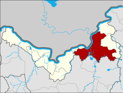 Amphoe location in Nong Khai Province | |
| Coordinates: 18°1′19″N 103°4′38″E / 18.02194°N 103.07722°ECoordinates: 18°1′19″N 103°4′38″E / 18.02194°N 103.07722°E | |
| Country | Thailand |
| Province | Nong Khai |
| Area | |
| • Total | 642.7 km2 (248.1 sq mi) |
| Population (2008) | |
| • Total | 96,580 |
| • Density | 149.1/km2 (386/sq mi) |
| Time zone | UTC+7 (ICT) |
| Postal code | 43120 |
| Geocode | 4305 |
Phon Phisai (Thai: โพนพิสัย, pronounced [pʰōːn pʰí.sǎj]) is a district (amphoe) of Nong Khai Province, northeastern Thailand.
History
The district was originally part of Mueang Phon Phaeng, now part of Rattanawapi District. In 1906 it was established as a district.
Geography
Neighboring districts are (from the east clockwise) Rattanawapi and Fao Rai of Nong Khai Province, Ban Dung, Sang Khom, and Phen of Udon Thani Province, and Mueang Nong Khai of Nong Khai. To the north across the Mekong river are the Laotian Vientiane Prefecture and Bolikhamxai Province.
Administration
The district is divided into 11 sub-districts (tambon), which are further subdivided into 151 villages (muban). Chumphon is a sub-district municipality (thesaban tambon) which covers parts of tambon Chumphon. There are a further 11 tambon administrative organizations (TAO).
| No. | Name | Thai | Villages | Pop.[1] |
|---|---|---|---|---|
| 1. | Chumphon | จุมพล | 24 | 19,738 |
| 2. | Wat Luang | วัดหลวง | 16 | 9,200 |
| 3. | Kut Bong | กุดบง | 14 | 8,681 |
| 4. | Chum Chang | ชุมช้าง | 19 | 9,498 |
| 6. | Thung Luang | ทุ่งหลวง | 12 | 5,172 |
| 7. | Lao Tang Kham | เหล่าต่างคำ | 13 | 6,376 |
| 8. | Na Nang | นาหนัง | 16 | 11,129 |
| 9. | Soem | เซิม | 10 | 7,426 |
| 13. | Ban Pho | บ้านโพธิ์ | 12 | 10,281 |
| 21. | Ban Phue | บ้านผือ | 7 | 5,440 |
| 22. | Sang Nang Khao | สร้างนางขาว | 8 | 3,639 |
Missing numbers are tambon which now form the districts Fao Rai and Rattanawapi.
References
- ↑ "Population statistics 2008". Department of Provincial Administration.
External links
- amphoe.com (Thai)