Baliangao, Misamis Occidental
| Baliangao | |
|---|---|
| Municipality | |
| Municipality of Baliangao | |
 | |
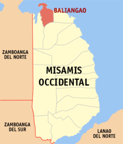 Map of Misamis Occidental with Baliangao highlighted | |
.svg.png) Baliangao Location within the Philippines | |
| Coordinates: 8°40′N 123°36′E / 8.67°N 123.6°ECoordinates: 8°40′N 123°36′E / 8.67°N 123.6°E | |
| Country |
|
| Region | Northern Mindanao (Region X) |
| Province | Misamis Occidental |
| District | 1st District |
| Founded | August 10, 1909 |
| Barangays | 15 (see Barangays) |
| Government [1] | |
| • Type | Sangguniang Bayan |
| • Mayor | Agne V. Yap Sr. |
| • Vice Mayor | Haneya Theresa Yap-Chiong |
| • Electorate | 11,714 voters (2016) |
| Area [2] | |
| • Total | 81.72 km2 (31.55 sq mi) |
| Population (2015 census)[3] | |
| • Total | 17,092 |
| • Density | 210/km2 (540/sq mi) |
| Time zone | UTC+8 (PST) |
| ZIP code | 7211 |
| PSGC | 104202000 |
| IDD : area code | +63 (0)88 |
| Climate type | Tropical climate |
| Income class | 5th municipal income class |
| Revenue (₱) | 57,785,423.28 (2016) |
| Native languages |
Subanon language Cebuano Tagalog |
| Website |
www |
Baliangao, officially the Municipality of Baliangao, is a 5th class municipality in the province of Misamis Occidental, Philippines. According to the 2015 census, it has a population of 17,092 people.[3]
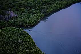
The Baliangao Protected Landscape and Seascape area is located within the municipality.
Barangays
Baliangao is politically subdivided into 15 barangays.
- Del Pilar
- Landing
- Lumipac
- Lusot
- Mabini
- Magsaysay
- Misom
- Mitacas
- Naburos
- Northern Poblacion
- Punta Miray
- Punta Sulong
- Sinian
- Southern Poblacion
- Tugas
Demographics
| Population census of Baliangao | ||||||||||||||||||||||||||||||||||||||||||||||
|---|---|---|---|---|---|---|---|---|---|---|---|---|---|---|---|---|---|---|---|---|---|---|---|---|---|---|---|---|---|---|---|---|---|---|---|---|---|---|---|---|---|---|---|---|---|---|
|
| |||||||||||||||||||||||||||||||||||||||||||||
| Source: Philippine Statistics Authority[3] [4] [5] [6] | ||||||||||||||||||||||||||||||||||||||||||||||
In the 2015 census, the population of Baliangao, Misamis Occidental, was 17,092 people,[3] with a density of 210 inhabitants per square kilometre or 540 inhabitants per square mile.
References
- ↑ "Municipality". Quezon City, Philippines: Department of the Interior and Local Government. Retrieved 31 May 2013.
- ↑ "Province: Misamis Occidental". PSGC Interactive. Quezon City, Philippines: Philippine Statistics Authority. Retrieved 12 November 2016.
- 1 2 3 4 Census of Population (2015). "Region X (Northern Mindanao)". Total Population by Province, City, Municipality and Barangay. PSA. Retrieved 20 June 2016.
- ↑ Census of Population and Housing (2010). "Region X (Northern Mindanao)". Total Population by Province, City, Municipality and Barangay. NSO. Retrieved 29 June 2016.
- ↑ Censuses of Population (1903–2007). "Region X (Northern Mindanao)". Table 1. Population Enumerated in Various Censuses by Province/Highly Urbanized City: 1903 to 2007. NSO.
- ↑ "Province of Misamis Occidental". Municipality Population Data. Local Water Utilities Administration Research Division. Retrieved 17 December 2016.
External links
- Philippine Standard Geographic Code
- Philippine Census Information
- Local Governance Performance Management System
Places adjacent to Baliangao, Misamis Occidental | ||||||||||
|---|---|---|---|---|---|---|---|---|---|---|
| ||||||||||
This article is issued from
Wikipedia.
The text is licensed under Creative Commons - Attribution - Sharealike.
Additional terms may apply for the media files.