Balangiga, Eastern Samar
| Balangiga | |
|---|---|
| Municipality | |
| Municipality of Balangiga | |
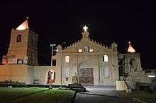
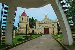 Balangiga Church | |
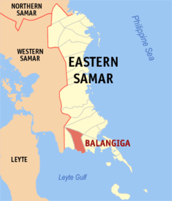 Map of Eastern Samar with Balangiga highlighted | |
.svg.png) Balangiga Location within the Philippines | |
| Coordinates: 11°07′N 125°23′E / 11.12°N 125.38°ECoordinates: 11°07′N 125°23′E / 11.12°N 125.38°E | |
| Country |
|
| Region | Eastern Visayas (Region VIII) |
| Province | Eastern Samar |
| District | Lone District |
| Barangays | 13 (see Barangays) |
| Government [1] | |
| • Type | Sangguniang Bayan |
| • Mayor | Randy D. Graza |
| • Electorate | 9,339 voters (2016) |
| Area [2] | |
| • Total | 190.05 km2 (73.38 sq mi) |
| Population (2015 census)[3] | |
| • Total | 14,085 |
| • Density | 74/km2 (190/sq mi) |
| Time zone | UTC+8 (PST) |
| ZIP code | 6812 |
| PSGC | 082602000 |
| IDD : area code | +63 (0)55 |
| Climate type | Tropical rainforest climate |
| Income class | 4th municipal income class |
| Revenue (₱) | 70,096,358.23 (2016) |
| Native languages |
Waray Tagalog |
| Website |
www |
Balangiga, (IPA: [ˌbalaŋˈhɪga]), officially the Municipality of Balangiga, is a 4th class municipality in the province of Eastern Samar, Philippines. According to the 2015 census, it has a population of 14,085 people.[3]
Balangiga is the site of the Balangiga massacre in 1901, which remains one of the longest-running and most controversial issues of the Philippine–American War.
History
Second World War and Japanese Occupation
On the height of World War II before the Allied Liberaion. The 3rd Samar Company of the Philippine Constabulary was constituting them of all combined military forces from Basey, Balangiga, Guiuan, and Salcedo, was integrated into the Imperial Japanese Army was operating in the Samar Island. The mainly general headquarters of the Philippine Constabulary 3rd Samar Company including the 10 infantry divisions under the 9th Military Area of the Philippine Commonwealth Army were based in Balangiga and around the two provinces in Leyte and Samar began the occupation conflicts against the enemy.
Began on September 18, 1944, the constable troops of the Philippine Constabulary 3rd Samar Company were ambushed in Barrio Cansumangkay the pursuing attack by the Imperial Japanese Army on their way to Balangiga to disarm the company members and constable soldiers on loyal to the U.S. liberation forces and adding them to ongoing soldiers of the Philippine Commonwealth Army units was going in the town and began the battling siege. Almost 31 Japanese and 2 Filipinos died in this battle.
On October 28, 1944, the general headquarters of the Philippine Constabulary 3rd Samar Company was become the establishment of the constable 9th Constabulary Regiment among the provincial companies in Leyte and Samar, constabulary battalions, infantry battalions and military-police battalions, was military stationed in this municipal town of Balangiga was start the Allied Liberation of the Philippines and they operates of the local constabulary soldiers around liberate area in two provinces of Samar and Leyte was added by combined Filipino and American troops under the Philippine Commonwealth Army and United States Army including the recognized guerrillas was fought against the Imperial Japanese troops until the end of the Second World War.
Geography
Balangiga is located on the southern coast of the island of Samar facing Leyte Gulf, and sits at the mouth of the Balangiga River. To the west lies the municipality of Lawaan, to the north is Llorente, and to the east are the municipalities of Quinapondan and Giporlos.
Barangays
Balangiga is politically subdivided into 13 barangays. [2]
- Bacjao
- Cag-olango
- Cansumangcay
- Guinmaayohan
- Poblacion I
- Poblacion II
- Poblacion III
- Poblacion IV
- Poblacion V
- Poblacion VI
- San Miguel
- Sta. Rosa
- Maybunga
Demographics
| Population census of Balangiga | ||
|---|---|---|
| Year | Pop. | ±% p.a. |
| 1903 | 4,914 | — |
| 1918 | 10,125 | +4.94% |
| 1939 | 19,858 | +3.26% |
| 1948 | 21,621 | +0.95% |
| 1960 | 8,215 | −7.75% |
| 1970 | 9,538 | +1.50% |
| 1975 | 8,474 | −2.34% |
| 1980 | 9,559 | +2.44% |
| 1990 | 9,565 | +0.01% |
| 1995 | 11,100 | +2.83% |
| 2000 | 10,662 | −0.86% |
| 2007 | 12,428 | +2.14% |
| 2010 | 12,756 | +0.95% |
| 2015 | 14,085 | +1.90% |
| Source: Philippine Statistics Authority[3] [4] [5] [6] | ||
In the 2015 census, the population of Balangiga, Eastern Samar, was 14,085 people,[3] with a density of 74 inhabitants per square kilometre or 190 inhabitants per square mile.
Transportation
Balangiga can be reached through public utility vans and buses from Tacloban City. Pedicabs (potpot), tricycles, and habal-habal by the means of inner town transportation.
Education
Balangiga has 9 public elementary schools, namely:
- Balangiga Central Elementary School
- Bacjao Elementary School
- Bangon Elementary School
- Cag-olango Elementary School
- Cansumangkay Elementary School
- Guinmaayohan Elementary School
- Maybunga Elementary School
- San Miguel Elementary School
- Santa Rosa Elementary School
Has 1 public secondary school:
- Southern Samar National Comprehensive High School
Has 1 private secondary school:
- MSH Sisters Academy Balangiga
Daughter Towns
The municipalities of Lawaan, Giporlos, and Quinapondan were former barangays of the municipality of Balangiga.
See also
References
- ↑ "Municipality". Quezon City, Philippines: Department of the Interior and Local Government. Retrieved 31 May 2013.
- 1 2 "Province: Eastern Samar". PSGC Interactive. Quezon City, Philippines: Philippine Statistics Authority. Retrieved 12 November 2016.
- 1 2 3 4 Census of Population (2015). "Region VIII (Eastern Visayas)". Total Population by Province, City, Municipality and Barangay. PSA. Retrieved 20 June 2016.
- ↑ Census of Population and Housing (2010). "Region VIII (Eastern Visayas)". Total Population by Province, City, Municipality and Barangay. NSO. Retrieved 29 June 2016.
- ↑ Censuses of Population (1903–2007). "Region VIII (Eastern Visayas)". Table 1. Population Enumerated in Various Censuses by Province/Highly Urbanized City: 1903 to 2007. NSO.
- ↑ "Province of Eastern Samar". Municipality Population Data. Local Water Utilities Administration Research Division. Retrieved 17 December 2016.
External links
| Wikimedia Commons has media related to Balangiga, Eastern Samar. |
- Philippine Standard Geographic Code
- Philippine Census Information
- Local Governance Performance Management System
Places adjacent to Balangiga, Eastern Samar | ||||||||||
|---|---|---|---|---|---|---|---|---|---|---|
| ||||||||||