Hunza Valley
| Hunza ہنزہ | |
|---|---|
| Valley | |
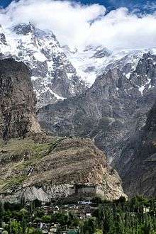
.jpg) The 7,788 metres (25,551 ft) tall Rakaposhi mountain towers over Hunza | |
 Hunza | |
| Coordinates: 36°19′01″N 74°39′00″E / 36.316942°N 74.649900°E [1] | |
| Country | Pakistan |
| Region | Gilgit Baltistan |
| Time zone | UTC+5 (PST) |
Hunza (Burushaski: ہنزو , Wakhi, and Urdu: ہنزہ) is a mountainous valley in the Gilgit-Baltistan region of Pakistan. Hunza is situated in the extreme northern part of Pakistan, bordering with the Wakhan Corridor of Afghanistan and the Xinjiang region of China.[2]
History
Hunza was formerly a princely state bordering Xinjiang (autonomous region of China) to the northeast and Pamir to the northwest, which survived until 1974, when it was finally dissolved by Zulfikar Ali Bhutto. The state bordered the Gilgit Agency to the south and the former princely state of Nagar to the east. The state capital was the town of Baltit (also known as Karimabad); another old settlement is Ganish Village which means ancient god "Ganesh village. Hunza was an independent principality for more than 900 years, until the British gained control of it and the neighbouring valley of Nagar between 1889 and 1892 through a military conquest. The then Mir/Tham (ruler) Rehab Ansari of Hunza fled to Kashghar in China and sought what would now be called political asylum.[3]
Mir/Tham
An account wrote by John Bidulf in his book 'Tribes of Hindukush'
| “ | The ruling family of Hunza is called Ayeshe (heavenly). The two states of Hunza and Nagar were formerly one, ruled by a branch of the Shahreis, the ruling family of Gilgit, whose seat of government was Nager. First muslim came to Hunza-Nagar Valley some 1000 years (At the time of Imam Islām Shāh 30th Imam Ismaili Muslims). After the introduction of Islam to Gilgit, married a daughter of Trakhan of Gilgit, who bore him twin sons, named Moghlot and Girkis. From the former the present ruling family of Nager is descended. The twins are said to have shown hostility to one another from birth. Thereupon their father, unable to settle the question of succession, divided his state between them, giving Girkis the north/west, and to Moghlot the south/east bank of the river.[4] | ” |
2010 landslide
In 2010, a landslide blocked the river and created Attabad Lake (also called Gojal Lake) [5], which threatened 15,000 people in the valley below and has effectively blocked 27 km of the Karakoram Highway.[6] The new lake extends 30 kilometres (19 mi) and rose to a depth of 400 feet (120 m) when it was formed as the Hunza River backed up.[7] The landslide completely covered sections of the Karakoram Highway.[7]
Geography
Hunza is divided into 3 geographic subdivisions:
Gojal Valley/Upper Hunza
Hunza District. The main towns, villages and valleys are:
Lower Hunza
Lower Hunza comprises the parts of Aliabad tehsil of Hunza District. The main towns, villages and valleys are:
- Nasirabad
- Khanabad
- Mayoon
- Hussainabad
- Khizerabad
Central Hunza
Central Hunza consists of the parts of Aliabad tehsil of Hunza District. The main towns, villages and valleys are:
- Aliabad
- Hyderabad Hunza
- Dourkhan
- Karimabad
- Altit
- Ahmedabad
- Burusho
- Ganish Village
- Hassanabad
- Murtazaabad
On 1 July 2018, Pakistan Army pilots in a daring mission rescued 3 foreign mountainers stuck in snow avalanche at above the height of 19,000 feet (5,800 m) on Ultar Sar Peak near Hunza. The parlous weather conditions had made it difficult for the Army helicopter to go forth with a rescue operation on the 7,388 metres (24,239 ft) high Ultar Sar. But they completed it. Bruce Normand and Timothy Miller from UK successfully rescued alive while their companion Christian Huber from Austria had succumbed to avalanche.[8][9]
Britain's High Commissioner Thomas Drew in Pakistan said, the mission had been “remarkable and dangerous”. “ Our gratitude to the Pakistan Army pilots who rescued two British climbers trapped by an avalanche on Ultar Sar Peak near Hunza. Our thoughts with their Austrian fellow climber who died ”.[10][11]
People
The local languages spoken include Burushaski, Wakhi and Shina. The literacy rate of the Hunza valley is believed to be more than 90%.[12] The historical area of Hunza and present northern Pakistan has had, over the centuries, mass migrations, conflicts and resettling of tribes and ethnicities, of which the Dardic Shina race is the most prominent in regional history. People of the region have recounted their historical traditions down the generations.
The longevity of Hunza people has been noted by some,[13] but others refute this as a longevity myth and cite a life expectancy of 110 years for men and 122 for women with a high standard deviation.[14] There is no evidence that Hunza life expectancy is significantly above the average of poor, isolated regions of Pakistan. Claims of health and long life were almost always based solely on the statements by the local mir (king). An author who had significant and sustained contact with Burusho people, John Clark, reported that they were overall unhealthy.[15]
Gallery
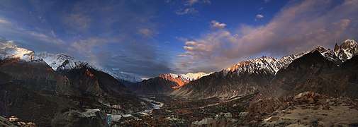 As the sun rises spreading colors around the Hunza valley.
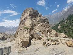 The Sacred Rocks of Hunza contain drawings dating from the area's Shamanist past.
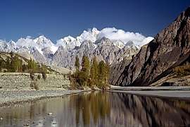 Hunza River near Gulmit.
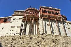
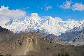 The 7,027 m (23,054 ft) tall Golden Peak as viewed from the Baltit Fort.
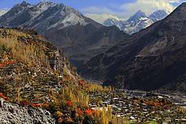 View from Altit Fort.
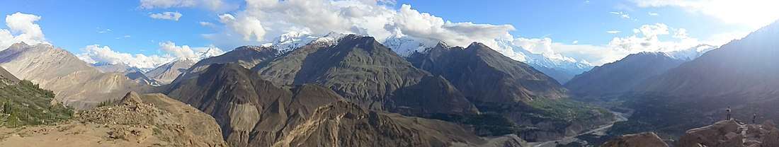
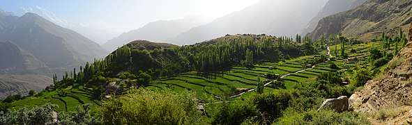 A Panoramic View of the Duikar Plateau and terrace fields of Hunza, Pakistan.
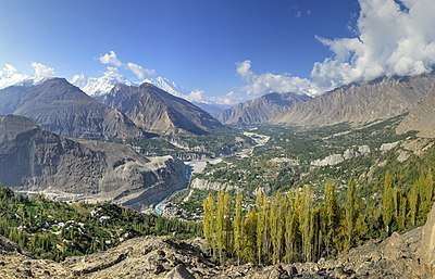 Hunza Valley, as viewed from the "Eagle's Nest".
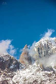
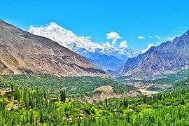 Snow covered peaks from Eagles Nest, Hunza valley.
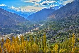 Duiker top in autumn.
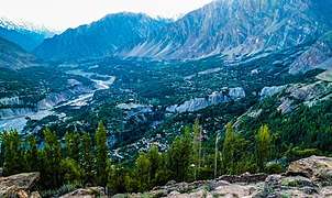 Eagle Nest, Hunza, Gilgit Baltistan, Pakistan.
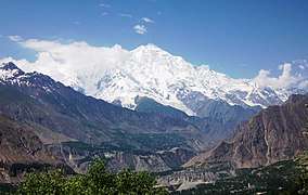 A view of Hunza and Rakaposhi-Northern Areas, Pakistan.
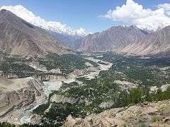 Hunza valley.
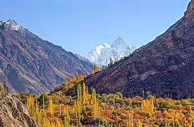 Hunza Valley in late autumn.
- State of Hunza (former)
- Hunza–Nagar District
- Shamanism in Hunza
- Northern Areas (former)
- Silk Road transmission of Buddhism
- Karakoram Highway
- Karakoram Mountains
- Neelam Valley
- Kalasha Valley
- Kaghan Valley
- Nagar Valley
References
- ↑ "Hunza on Google Maps". Google Maps. Retrieved 27 June 2018.
- ↑ "Mountainous Valley situated in exttreme northern part of Pakistan". www.dreamstime.com. Retrieved 3 June 2018.
- ↑ Valley, Hunza. "Hunza Valley". www.skardu.pk. Skardu.pk. Retrieved 23 November 2016.
- ↑ Tribes of the Hindoo Koosh by John Bidulph page 26
- ↑ "Gojal Lake Hazard", Pamir Times, Islamabad, 21 July 2015
- ↑ http://www.dawn.com/wps/wcm/connect/dawn-content-library/dawn/news/sci-tech/03-rising-water-threatens-villages-in-hunza-ss-03
- 1 2 Michael Bopp; Judie Bopp (May 2013). "Needed: a second green revolution in Hunza" (PDF). HiMaT. p. 4. Retrieved 26 November 2015. Karakorum Area Development Organization (KADO), Aliabad
- ↑ "Pakistan Army Pilots rescued 3 foreign mountainers". en.dailypakistan.com.pk. Retrieved 7 July 2018.
- ↑ "Mountainers News on Thenews.com.pk". www.thenews.com.pk. Retrieved 7 July 2018.
- ↑ "Britain's High Comissioner in Pakistan admired Pak Army Pilots for rescued the two British Climbers". www.telegraph.co.uk. Retrieved 8 July 2018.
- ↑ "Major General Asif Ghafoor also tweeted about it". www.forces.net. Retrieved 12 July 2018.
- ↑ Siddiqui, Shahid. "Hunza disaster and schools". Dawn. Retrieved 6 July 2012.
- ↑ Wrench, Dr Guy T (1938). The Wheel of Health: A Study of the Hunza People and the Keys to Health. 2009 reprint. Review Press. ISBN 978-0-9802976-6-9. Retrieved 12 August 2010
- ↑ Tierney, John (29 September 1996). "The Optimists Are Right". The New York Times.
- ↑ "Hunza - The Truth, Myths, and Lies About the Health and Diet of the "Long-Lived" People of Hunza, Pakistan, Hunza Bread and Pie Recipes". www.biblelife.org.
- Kreutzmann, Hermann, Karakoram in Transition: Culture, Development, and Ecology in the Hunza Valley, Oxford University Press, 2006. ISBN 978-0-19-547210-3
- Leitner, G. W. (1893): Dardistan in 1866, 1886 and 1893: Being An Account of the History, Religions, Customs, Legends, Fables and Songs of Gilgit, Chilas, Kandia (Gabrial) Yasin, Chitral, Hunza, Nagyr and other parts of the Hindukush, as also a supplement to the second edition of The Hunza and Nagyr Handbook. And An Epitome of Part III of the author’s “The Languages and Races of Dardistan.” First Reprint 1978. Manjusri Publishing House, New Delhi.
- Lorimer, Lt. Col. D.L.R. Folk Tales of Hunza. 1st edition 1935, Oslo. Three volumes. Vol. II, republished by the Institute of Folk Heritage, Islamabad. 1981.
- Sidkey, M. H. "Shamans and Mountain Spirits in Hunza." Asian Folklore Studies, Vol. 53, No. 1 (1994), pp. 67–96.
- History of Ancient Era Hunza State By Haji Qudratullah Beg English Translation By Lt Col (Rtd) Saadullah Beg, TI(M)
- Wrench, Dr Guy T (1938), The Wheel of Health: A Study of the Hunza People and the Keys to Health, 2009 reprint, Review Press, ISBN 978-0-9802976-6-9, retrieved 12 August 2010
External links
| Wikimedia Commons has media related to Hunza Valley. |