Bagnotar
| Bagnotar باجنوتار | |
|---|---|
| Union Council | |
 | |
| Coordinates: 34°7′0″N 73°20′0″E / 34.11667°N 73.33333°ECoordinates: 34°7′0″N 73°20′0″E / 34.11667°N 73.33333°E | |
| Country |
|
| Province |
|
| District | Abbottabad |
| Tehsil | Abbottabad |
| Government | |
| • Member District Council | Sardar Saeed Anwer |
| • Member Tehsil Council | Sardar Shuja Ahmed |
| Population (2017)[1] | |
| • Total | 13,862 |
| [2] | |
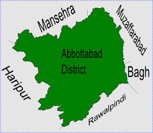
Bagnotar is a union council of Abbottabad District in Khyber-Pakhtunkhwa province of Pakistan.[3] Bagnator is situated on the Abbottabad-Nathi Gali Road some 18 kilometers away from Abbottabad.
Location
Union council Bagnotar is situated in central part of District Abbottabad in Abbottabad Tehsil, and lies to south east of Abbottabad city – the capital city of the district. The area is included in the Lower Galliyat Belt. The main tribes of Bagnotar are the Karlal, Awan, Abbasi, Rajputs and Jadoon. However, other small ethnic groups are also settled in the area. Bagnotar is bounded by the following union councils, to the north by Sarbhana, and Beerangali, to the east Nagri Bala & Nathiagali, and to the south by Namli Maira and Phalkot, and to the west by Bagh.
Bagnotar town has an elevation of 1775 metres,[2] and is located approximately 16 km from Abbottabad on Abbottabad-Murree Road. A lush green pine valley stretched on 810 square kilometers.The major landscape as well as the settlement of Bagnotar is located along the Barrian-Nathigali-Abbottabad Road (Abbottabad Murree Road), the 11 kilometers of which passes through the land of Bagnotar.
Subdivisions
Bagnotar has three subdivisions known as the "village councils". These three are:
Educational Institutes in Bagnotar
Government Institutes of education in Bagnotar are as follows
Village Council Bagnotar
Government Boys Higher Secondary School Bagnotar
Government Girls High School Bagnotar
Government Primary School Bagnotar
Government Primary School Khurri Banda Bagnotar
Government Primary School Gulaga Bagnotar
Government Primary School Seri, Bagnotar
Government Primary School Gaiya Bagnotar
Village Council Bandi Maira
Government Primary School Riyan Tareeda
Government Girls Primary School Cham Rajput
Post office Chum Rajput Bandi Maira.
Government Primary School Bandi Maira Nakrorha/Chatarnath/Maira.
Government Girls High School Drang Bandi Maira..
Village Council Chahan
Government Primary School Chahan, Bandi Maira
Vegetation
The vegetation in Bagnotar is naturally grown. Both coniferous and deciduous species are present on a large area of the whole union council. The notable species are Pinus wallichiana, Pinus roxburghii, Cedrus deodara, Taxus baccata, Diospyrus lotus, Salix tetrasperma, Quercus dilatata, Morus elba, Aesculus indica.
2005 Earthquake
On 8 October 2005 various parts of Abbottabad District were affected by the Pakistan earthquake. Unlike neighbouring Kashmir, the loss in human life was relatively low in this area, with 511 dead and 622 injured. Although the impact on infrastructure was still severe.[4]
References
- ↑ "DISTRICT AND TEHSIL LEVEL POPULATION SUMMARY WITH REGION BREAKUP: KHYBER PAKHTUNKHWA" (PDF). Pakistan Bureau of Statistics. 2018-01-03. Retrieved 2018-04-17.
- 1 2 Falling Rain: Location of Bagnotar
- ↑ Administrative Units of District Abbottabad Archived April 3, 2007, at the Wayback Machine.
- ↑ Earthquake impact – In Abbottabad District Archived 2007-05-06 at the Wayback Machine.
Village Bagh. . 1 High School for boys. . 6 Primary School for boys . 5 Primary School for Girls . 1 Model School for girls (established 2011) . 1 Dispensary where any time one doctor available. This village outside of Bagnotar.