Badulla
| Badulla බදුල්ල | |
|---|---|
| City | |
| City of Badulla | |
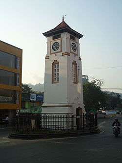 Badulla clock tower | |
 Badulla | |
| Coordinates: 6°59′5″N 81°3′23″E / 6.98472°N 81.05639°ECoordinates: 6°59′5″N 81°3′23″E / 6.98472°N 81.05639°E | |
| Country | Sri Lanka |
| Province | Uva Province |
| District | Badulla |
| Government | |
| • Type | Municipal Council |
| Area | |
| • Total | 10 km2 (4 sq mi) |
| Elevation | 680 m (2,230 ft) |
| Population (2011) | |
| • Total | 47,587 |
| • Density | 4,387/km2 (11,360/sq mi) |
| Time zone | UTC+5:30 (Sri Lanka Standard Time Zone) |
Badulla (Sinhalese: බදුල්ල, Tamil: பதுளை) is the main city of Uva Province situated in the lower central hills of Sri Lanka. It is the capital city of Uva Province and the Badulla District.
Geography
Badulla is located in the southeast of Kandy, almost encircled by the Badulu Oya River, about 680 m (2,230 ft) above sea level and is surrounded by tea plantations. The city is overshadowed by the Namunukula range of mountains (highest peak 2,016 m (6,614 ft) above sea level). It was a base of a pre-colonial Sinhalese local prince (regional king) who ruled the area under the main King in Kandy before it became part of the British Empire. Later, it became one of the provincial administrative hubs of the British rulers. The city was the end point of upcountry railway line built by the British in order to take mainly tea plantation products to Colombo.
Badulla is about 230 km (140 mi) away from Colombo towards the eastern slopes of the central hills of Sri Lanka. There are multiple routes to Badulla from Colombo, Kandy and Galle. From Colombo, one can travel via Ratnapura, Balangoda, Haputale, Bandarawela and Hali Ela along A4 and A16 to Badulla, which may take 5–6 hours. From Kandy there are two routes: either via "Victoria-Randenigala Raja Mawatha" or via Nuwara Eliya (route A5). From Galle, the best route is via Matara, Hambantota, Wellawaya, Ella, Demodara and Hali Ela (route A2). All routes are scenic and one can see splendid views of the geography, which changes while travelling. Badulla and its surroundings are highly recommended for eco-tourists as Horton Plains National Park and the Knuckles mountains are a few hours away.
History and present day
Badulla was an isolated village until the British built roads from Kandy and Nuwara Eliya in the mid 19th century, as part of the growing plantation economy.
By the 20th century Badulla had become a regional hub, with the British establishing it as the capital of Uva Wellassa, now known as the Uva Province. Badulla still has a number of British colonial buildings existing, including the Badulla railway station, which opened in 1924. The station is the last train station on the Main Line, which served as the rail line by the British to transport tea collected from the Badulla district to Colombo. Badulla district is one of the leading tea producing districts, second only behind the Nuwara-Eliya District.
The town has grown steadily since the country's independence from approximately 13,000 in 1946, to 38,000 in 1977 and 47,587 in 2011.[1]
Badulla is a multi-national city with the ancient Muthiyangana Temple situated in its heart. The Catholic Church has a diocese headquartered here. It is emerging as a well developed city in Sri Lanka with a state of the art provincial hospital and many more developments.
Tourist attractions
- Muthiyangana temple is an ancient Buddhist temple located in the middle of Badulla. It is regarded as one of the Solosmasthana, the sixteen sacred places in Sri Lanka, believed by Buddhists to have been visited by Gautama Buddha.
- Badulla Kataragama Devalaya is an ancient devalaya, situated in Badulla town. It is one of shrines dedicated to Sinhalese deity Kataragama deviyo.
- Old Welekade Market is a historic colonial building, situated in middle of the Badulla town. It was built in 1889 by British.
- Dunhinda Falls, a 64 metres (210 ft) high waterfall, is located 5 kilometres (3.1 mi) north of Badulla. This is one of the most popular waterfalls of Sri Lanka, mentioned in several famous songs and works of literature. It draws many local and foreign tourists to the region.
- Bogoda ancient wooden bridge is one of the oldest surviving wooden bridges in the country (being over 400 years old) and is located 13 kilometres (8.1 mi) south of Badulla, close to the town of Hali-ela.
- Demodara railway station is between Ella and Udoowara railway stations. Demodara railway station is famous because the railway turns from the platform, and then goes under the railway station in the tunnel.
- St Mark's Church, built in memory of Major Thomas William Rogers, Assistant Government Agent of Uva Province, who died 7 June 1845 after being struck by lightning at the Sherwood Estate in Haputale. It was the first church to be consecrated (25 April 1857) by the first Bishop of Colombo Rev. James Chapman.
Demographics
| Ethnicity | Population[2] | % of total |
|---|---|---|
| Sinhalese | 29,961 | 73.22 |
| Sri Lankan Moors | 5,519 | 13.49 |
| Sri Lankan Tamils | 2,717 | 6.64 |
| Indian Tamils | 1,989 | 4.86 |
| Other (including Burgher, Malay) | 735 | 1.80 |
| Total | 40,920 | 100 |
 Tea, for which Badulla is famous
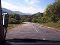 Driving to Badulla on Raja Mawatha
 Badulla railway station
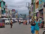 Street scene
See also
References
- ↑ Peebles, Patrrick (2015). Historical Dictionary of Sri Lanka. Rowman & Littlefield. p. 49. ISBN 9781442255852.
- ↑ Archived September 8, 2006, at the Wayback Machine.
External links
| Wikivoyage has a travel guide for Badulla. |
| Wikisource has the text of the 1911 Encyclopædia Britannica article Badulla. |
- Office of the Governor - Uva / ඌව පලාත් ආණ්ඩුකාරවර කාර්යාලය
- Provincial General Hospital - Badulla / පළාත් මහ රෝහල - බදුල්ල
- A school in Badulla District
- Badulla
- Detailed map of Badulla vicinity and Sri Lanka
| ||
| National capitals# |
| |
|---|---|---|
| Municipal councils | ||
| Urban councils |
| |
Note: * also a Provincial capital, # also a Municipal council | ||
Provincial capitals of Sri Lanka | ||
|---|---|---|