Akkaraipattu
| Akkaraipattu அக்கரைப்பற்று අක්කරපත්තුව | |
|---|---|
| Town | |
 Akkaraipattu | |
| Coordinates: 7°13′0″N 81°51′0″E / 7.21667°N 81.85000°E | |
| Country | Sri Lanka |
| Province | Eastern |
| District | Ampara |
| DS Division | Akkaraipattu |
| Government | |
| • Type | Municipal Council |
| • Mayor | Ahamed Zackie Athaullah (NC) |
| Area | |
| • Total | 6,000 ha (15,000 acres) |
Akkaraipattu (Tamil: அக்கரைப்பற்று, Sinhala: අක්කරපත්තුව) is a coastal town in the Ampara District of Sri Lanka, in the Eastern Province. It is approximately 250 km (160 mi) east of Colombo. During the period of British rule, the town was callled Karunkodithivu. Akkaraipattu acts as an agro-economic hub with vast extents of paddy field surrounding the township.[1] The Akkaraipattu massacre took place there in 1986, where it was alleged that approximately 80 farm workers were killed by Sri Lankan Army personnel[2].
Location
The town is located just south of the center of the eastern coastline and can be found through the Siyambalanduwa - Damana - Ampara Road (A25) and the Colombo-Ratnapura-Wellawaya-Batticaloa Road (A4). Akkaraipattu's covers an area of 48.36 km2 (18.67 sq mi). The Urban Development Area (UDA) of Akkaraipattu includes Akkaraipattu Municipal Council (AMC), which covers 5.07 km2 (1.96 sq mi) and includes 23 GN Divisions of Akkaraipattu Municipal Council and five GNDs from the Pradeshiya Sabha area.[3]
History
During the period of British rule, Akkaraipattu was under the Batticaloa District. The Government Agent was the head of each district and the posts of the Maniyakkara (Assistant Government Agent) and Vanniyanar (Additional Government Agent were under him.. The Vanniyanar appointed two officers directly responsible for irrigation, development and education. Under this structure, agriculture and road construction became a prominent part of the development of the Akkaraipattu area. The Vanniyanar was also responsible for appointing the Chairman and members of local government organizations, who would then conduct the functions of a local council including collecting taxes, civic construction and maintaining law and order. The construction of the Gal Oya scheme, which commenced in 1949 and continues to be improved upon, further established agriculture as a driving economic force, in particular paddy and sugar cane. Road development also continued in parallel with the development of land for agriculture[4]. In February of 1986, the Akkaraipattu Massacre occurred when farmers were caught up in fighting between the Sri Lankan Army and Tamil seperatists. [5]
Topography
The terrain of the Akkaraipattu area rises from sea level to 39 m (128 ft) above sea level. The terrain is noticeable for large areas that are generally level and covered with agriculture. Settlements are scattered throughout the area.
Soil types
The susceptibility of soil types to drought is a major concern in Akkaraipattu where three main soil types can be found: Alluvial soil of variable drainage and texture, Reddish-brown soil, and Solodized Solonetz. The Alluvial soil is generally found on flat flood plains. Poorly drained alluvial soil is grey in colour whilst those with better drainage are coloured brown to yellowish brown. The Reddish brown soil has a reddish-brown surface colour when dry and then turns to a dark reddish-brown colour when wet. Solodized Solonetz is not a fertile soil with a pH value greater than 8.5.
Hydrology
The Akkaraipattu has three major water tanks: Ilukkuchchenai Tank, Neethai Tank, and Thillai Aru.[6] These tanks, combined with the water catchments assist in supporting the paddy cultivation in the area.
Climate
Akkaraipattu is located in the dry zone of Sri Lanka and within the limits of the project area there are no significant differences in the rainfall pattern. The northeast monsoon period (October- February) is when the highest monthly rainfall is received in Akkaraipattu, conversely, the dry season months of June, July and August is when the lowest rainfall is received. The seasonal rain provides for the cultivation of crops during the maha season. Figure 8 provides average rainfall on a monthly basis between 1993-2011, (this figure was developed with information gathered from the Meteorology Department). The average annual rainfall is 119 mm (4.7 in).
The lowest number of thundering days is generally recorded during the months of January and February whilst the highest number of days is recorded in September and October prior to the commencement of the monsoon.
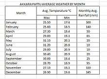
An AusAid/UN-Habitat analysis of temperature records for the years 1950-2010 indicated that highest temperatures in the Akkaraipattu area are experienced in May, June and July, (around 34°C), while lowest temperatures are recorded in the months of January and December (around 23 °C). The mean annual temperature is 30°C.[7]
Demography
In 2012 there were 39,223 residents in Akkaraipattu administrative sub-unit, where the town of Akkaraipattu is located.[8] According to the website of the Akkaraipattu Divisional Secretariat, 42,375 people in 22,536 families were living in the DS division as of 2012. Of these inhabitants, 20,712 were male and 21,663 female.[9]
Schools in the Akkaraipattu Education Zone
- Sri Rama krishna National College Tamil
- RKM Tamil Vidyalayam
- Aalayadivaembu Tamil School
- Vivekananthair Tamil Vidyalayam
- Kolaavil Tamil Vidyalayam
- Ak/Sri Dhammarathanana Sinhala Vidyalaya
- Akkaraipattu Muslim Central College (MC College)
- As-Siraj Maha Viddiyalaya
- Ayesha Muslim Ladies College
- Fayiza Maha Vidayalayam
- Al-Munawwara College
- Govt. Muslim Boys Vidyalaya (GMBV)
- Ar-Raheemiya School
- Al-Badur School
- Al-Fathimiya School
- Al-Hidaya School
- Dr-Badi-Ud-Din Mahmud School
- Hijra School
- Ilukkuchenai Al-Hudha Vid
- Al-Kamar Vid
- Kathiriya Vid
- Murawodai Shamsul Uloom Vid
- Segu Sikkanthar Oliullah Vid
- Sir Razeek Fareed Vid
- Zahira Vidyalaya
Akkaraipattu Muslim Central College (National School) (MCC)
Akkaraipattu Muslim Central College (AMCC), the premier education provider for the Muslim community, was founded in 1946. It became the second Muslim National School in Sri Lanka and the first national school in the Eastern Province in 1992. It has a student population of more than 2500 and 170 staff members.
References
- ↑ "Akkaraipattu, Sri Lanka: Disaster risk reduction and preparedness plan - Towards a sustainable and resilient city." The United Nations Human Settlements Programme, UN-Habitat 2014 Chapter 2 p13 http://unhabitat.lk/publications/disaster-risk-reduction-and-preparedness-plans/ http://unhabitat.lk/wp-content/uploads/2015/01/DRRAkkaraipattu.pdf Accessed 28 July 2018
- ↑ Dealing with diversity : Sri Lankan discourses on peace and conflict. Frerks, Georg, 1954-, Klem, Bart. The Hague: Netherlands Institute of International Relations 'Clingendael'. cop. 2004. ISBN 9050310915. OCLC 66616719. Check date values in:
|date=(help) - ↑ "Akkaraipattu". apecintl.org. Retrieved 2018-08-07.
- ↑ Wijeratne, L (7 November 2017). "A nation energised with Gal Oya mission". dailynews.lk.
- ↑ Dealing with diversity : Sri Lankan discourses on peace and conflict. Frerks, Georg, 1954-, Klem, Bart. The Hague: Netherlands Institute of International Relations 'Clingendael'. cop. 2004. ISBN 9050310915. OCLC 66616719. Check date values in:
|date=(help) - ↑ "Akkaraipattu Disaster Risk Reduction and Preparedness Plan" (PDF). www.unhabitat.lk. January 2015.
- ↑ "Akkaraipattu, Sri Lanka: Disaster risk reduction and preparedness plan - Towards a sustainable and resilient city." UN-Habitat, 2014 Ch 2.16 http://unhabitat.lk/publications/disaster-risk-reduction-and-preparedness-plans/ http://unhabitat.lk/wp-content/uploads/2015/01/DRRAkkaraipattu.pdf Accessed 29 July 2018
- ↑ Map: P3.52.1.1 Population by DS Division (Akkaraipattu) ‐ Ampara District, 2012. The Population Atlas of Sri Lanka 2012. Census of Population and Housing 2012. Department of Census and Statistics, Ministry of Finance and Planning, Sri Lanka. Accessed 27 July 2018. http://www.statistics.gov.lk/PopHouSat/PopulationAtla_2012/04_DSLevelMaps/Map%20P3.52.1.1%20Ampara-%20Population%20%20%20by%20DS.pdf
- ↑ "Development Needs in Akkaraipattu." Akkaraipattu Divisional Secretariat. 29 February 2012. Accessed 27 July 2018. http://www.akkaraipattu.ds.gov.lk/index.php?option=com_content&view=article&id=31&Itemid=54&lang=en
External links
Coordinates: 7°13′N 81°51′E / 7.217°N 81.850°E
| National capitals# |
| |
|---|---|---|
| Municipal councils | ||
| Urban councils |
| |
Note: * also a Provincial capital, # also a Municipal council | ||