Auraiya, Nepal
| Auraiya औरैया | |
|---|---|
| Village development committee | |
 Auraiya Location in Nepal | |
| Coordinates: 26°47′N 85°14′E / 26.78°N 85.23°ECoordinates: 26°47′N 85°14′E / 26.78°N 85.23°E | |
| Country |
|
| Zone | Narayani Zone |
| District | Rautahat District |
| Population (2001) | |
| • Total | 8,836 |
| Time zone | UTC+5:45 (Nepal Time) |
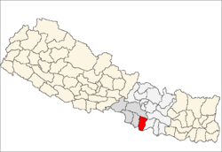
Auraiya is a village development committee in Rautahat District in the Narayani Zone of south-eastern Nepal. Auraiya is 6 KM west from the District headquarters Gaur. The village takes its name from "AMLA" which means "Indian gooseberry". At the time of the 2014 Nepal census it had a population of 10,832(Male-5,630 Female-5,202,93.17% Hindu, 6.83% Muslim) people living in more than 1648 individual households. The literacy rate is 77% which is higher than average villages of Nepal. Most of the people of the village are employed in the "Government Services" of Nepal like Engineering, Forestry, Medicine, Education & so many.
kala kunj is one of the best private school from class nursary to slc
name of school :- kala kunj secondary english boarding school
No. of student :- approx.400
principal :- Er ram-yesh jha
Numbers of teachers :- 15
Border
Its borders Bihar in south with two villages Hirapur and Chainpur.
References