Hornád
| Hornád | |
|---|---|
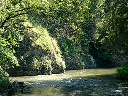 The gorge of Hornád river in Slovak Paradise | |
| Other name(s) | Hernád |
| Country | Slovakia, Hungary |
| Physical characteristics | |
| Main source | Kráľova hoľa hill |
| River mouth |
Sajó 47°59′25″N 20°55′47″E / 47.9903°N 20.9296°ECoordinates: 47°59′25″N 20°55′47″E / 47.9903°N 20.9296°E |
| Length | 286 km (178 mi) |
| Basin features | |
| Progression | Sajó→ Tisza→ Danube→ Black Sea |
| Tributaries |
|

The Hernád river at Gibárt, Borsod-Abaúj-Zemplén County, Hungary
Hornád (Slovak, pronounced [ˈɦɔrnaːt]) or Hernád (Hungarian, pronounced [ˈhɛrnaːd]) is a river in eastern Slovakia and north-eastern Hungary.
It is a tributary to the river Slaná (Sajo). The source of the Hornád is the eastern slopes of Kráľova hoľa hill, southwest of Vikartovce.[1]
The river is 286 km long, with 178 km located in Slovakia, and the remaining 108 km in Hungary.[2]
Cities along its course are Spišská Nová Ves and Košice, both in Slovakia. It flows into the river Sajó (Slovak Slaná) southeast of Miskolc.[1]
Along the river are a series of 6 separate limestone rocky cliffs and steep slopes, which collectively make up the Site of Community Importance 'Hornádske vápence'.[3]
References
- 1 2 "The Hornád River". splavujeme.sk. Retrieved 29 December 2015.
- ↑ Slovak Environmental Agency. "1 Introduction". Pilot Project PiP1: Hornád/Hernád, Integrated Revitalisation of the Hornád/Hernád River Valley. TICAD. p. 5. Retrieved 23 July 2015.
- ↑ Vadel, Ľuboš. "Phytosociological Assessment Of Site Of Community Importance Hornádske Vápence" (PDF). conferences.ukf.sk. Retrieved 2 September 2015.
This article is issued from
Wikipedia.
The text is licensed under Creative Commons - Attribution - Sharealike.
Additional terms may apply for the media files.