'Asir Region
Coordinates: 19°0′N 43°0′E / 19.000°N 43.000°E
| Asir عسير | |
|---|---|
| Region | |
| Asir Region | |
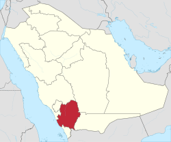 Map of Saudi Arabia with 'Asir highlighted | |
| Capital | Abha |
| Boroughs | 13 |
| Government | |
| • Governor | Faisal bin Khalid |
| • Vice Governor | Prince Turki Bin Talal bin Abdulaziz Al Saud |
| Area | |
| • Total | 76,693 km2 (29,611 sq mi) |
| Population (2010) | |
| • Total | 1,913,392 |
| ISO 3166-2 | 14 |
The 'Asir Region (or 'Aseer, Arabic: عسير ʿAsīr) is a region of Saudi Arabia located in the southwest of the country that is named after the ʿAsīr tribe. It has an area of 76,693 square kilometres (29,611 sq mi) and an estimated population of 1,913,392. It shares a short border with Yemen.
The capital of the Asir Region is Abha. Other towns include Khamis Mushait, Bisha and Bareq. The regional governor is Faisal bin Khalid bin Abdulaziz Al Saud (appointed 16 May 2007), a son of King Khalid of Saudi Arabia. He replaced his cousin, Khalid bin Faisal Al Saud, who was made governor of Makkah Region the same day.
Geography
Geographically, the 'Asir Region is situated on a high plateau that receives more rainfall than the rest of the country and contains the country's highest peaks, which rise to almost 3,000 metres (9,800 ft) at Jabal Sawda near Abha. Though data is exceedingly sparse and unreliable, the average annual rainfall in the highlands probably ranges from 300 to 500 millimetres (12 to 20 in) falling in two rainy seasons, the chief one being in March and April, with some rain in the summer. Temperatures are very extreme, with diurnal temperature ranges in the highlands the greatest in the world. It is common for afternoon temperatures to be over 30 °C (86 °F), yet mornings can be extremely frosty and fog can cut visibility to near zero percent. As a result, there is much more natural vegetation in 'Asir than in any other part of Saudi Arabia, with sheltered areas even containing areas of dense coniferous forests, though more exposed ridges still are very dry.
'Asir is home to many farmers who chiefly grow wheat and fruit crops, though irrigation has greatly expanded production in modern times.
Governorates
The region is divided into sixteen governorates (with 2010 Census populations[1]):
- Abha (+366,551)
- Muhayil (+228,979)
- An-Namas (+54,119)
- Billasmar (+34,080)
- Billahmar (+25,709)
- Balqarn
- Bareq (+74,391)
- Bishah (+205,346)
- Khamis Mushayt (+512,599)
- Rijal Alma (+65,406)
- Zahran Al-Janub (+63,119)
- Tathlith (+59,188)
- Sarat Abidah (+67,120)
- Ahad Rifaydah (+113,043)
- Al-Majardah (+103,531)
- Al-Harajah
History
In 25 B.C. Aelius Gallus marched his legions south from Egypt on a 1,300-mile expedition to take control of the ancient overland trade routes between the Mediterranean and what is now Yemen and Hadhramaut. The Romans wanted control of those routes because they were desperate for money and hoped to raise some by capturing Marib, capital of Yemen, and taking control of the trade in incense - then a priceless commodity - and other valuable aromatics. As it turned out, however, the expedition was a disaster and little information about 'Asir emerged.
By 1920, however, ibn Saud, founder of Saudi Arabia, had begun to recoup the losses of the House of Sa'ud and to unify most of the Peninsula under his rule. As part of this campaign, he sent his Bedouin warriors also known as the Ikhwan to occupy 'Asir, and from then on 'Asir was controlled by the House of Sa'ud - a situation formalized in 1934 with the signing of the Treaty of Taif between Saudi Arabia and Yemen.
Even then the region was still largely unknown to the West. In 1932, St John Philby, one of the first Europeans to explore and map the Peninsula, did enter 'Asir, but as he did not publish his observations until 1952, the area remained one of the blank spots on the world's map.
Economy
Historically, 'Asir was known for producing coffee, wheat, alfalfa, barley, senna, and frankincense.[2][3][4] Wheat was grown in the summer and sesame has been grown in wetter areas of the region.[3][5] Straw was used to make mats, hats, and baskets, with specific skills being credited to Somali women in the area. Tribes in the area also weaved tents from straw.[6]
List of governors
- Khalid bin Faisal (1971–2007)
- Faisal bin Khalid (2007–present)
See also
References
- Mackey, Sandra. The Saudis: Inside the Desert Kingdom. Updated Edition. Norton Paperback. W.W. Norton and Company, New York. 2002 (first edition: 1987). ISBN 0-393-32417-6 pbk.
Notes
- ↑ http://www.data.gov.sa/ar/node/1729/download
- ↑ Prothero, G.W. (1920). Arabia. London: H.M. Stationery Office. p. 83. Archived from the original on 2016-12-27. Retrieved 2016-08-15.
- 1 2 Prothero, G.W. (1920). Arabia. London: H.M. Stationery Office. p. 84. Archived from the original on 2016-12-27. Retrieved 2016-08-15.
- ↑ Prothero, G.W. (1920). Arabia. London: H.M. Stationery Office. p. 86. Archived from the original on 2016-12-27. Retrieved 2016-08-15.
- ↑ Prothero, G.W. (1920). Arabia. London: H.M. Stationery Office. p. 85. Archived from the original on 2016-11-15. Retrieved 2016-08-15.
- ↑ Prothero, G.W. (1920). Arabia. London: H.M. Stationery Office. p. 99. Archived from the original on 2016-08-22. Retrieved 2016-08-15.
External links
| Wikimedia Commons has media related to Asir. |

- Asir National Park: Splendid Arabia, An Online Guide to the Kingdom of Saudi Arabia
Places adjacent to 'Asir Region | |
|---|---|
Pre-Saudi states | ||
|---|---|---|
| Saudi-ruled |
| |
| Conquered | ||