Jizan Region
Coordinates: 17°30′N 42°30′E / 17.500°N 42.500°E
| Jizan جيزان | |
|---|---|
| Region | |
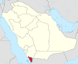 Map of Saudi Arabia with Jizan highlighted | |
| Capital | Jizan |
| Boroughs | 14 |
| Government | |
| • Governor | Prince Muhammad bin Nasr |
| • Vice Governor | Muhammad bin Abdulaziz bin Muhammad bin Abdulaziz |
| Area | |
| • Total | 11,671 km2 (4,506 sq mi) |
| Population (2010) | |
| • Total | 1,365,110 |
| • Density | 120/km2 (300/sq mi) |
| ISO 3166-2 | 09 |
Jizan Region (Arabic: جيزان Jizān) is the second smallest (after Al Bahah) region of Saudi Arabia. It stretches 300 km along the southern Red Sea coast, just north of Yemen. It covers an area of 11,671 km² and has a population of 1,365,110 at the 2010 census (preliminary result). The region has the highest population density in the Kingdom. The capital is the city of Jizan; Muhammad bin Nasser bin Abdulaziz is the current Governor.
The region includes over 100 islands in the Red Sea. Around 34% of citizen families in Jizan live in poverty.[1] The Farasan Islands, Saudi Arabia's first conservation protected area, are home to the endangered Arabian gazelle and, in winter, migratory birds from Europe.
Geography
The region divides into three parts.
- The Al-Sarawat mountains inland, which rise to about 3,000 metres.
- The Alhazoun forest district consists of forest broken by some areas of rich pasture.
- The plains are noted for the production of coffee beans, cereal grain crops (barley, millet and wheat) and fruit (apples, bananas, grapes, mangoes, papayas, plums and citrus varieties).
Though the climate on the highlands is similar to the relatively wetter climate of 'Asir, the coastal regions of Jazan province are part of Tihamah, probably the hottest place in the country, with mean maximum temperatures ranging from 40 °C (104 °F) in July to 31 °C (88 °F) in January. High humidity from coastal lagoons makes the climate even less bearable than it would be otherwise. Rainfall is extremely low at less than 75 millimetres (3 inches) per year. Sabya is located in the center between the mountain and the beach.
Sub-divisions
The region is sub-divided into 14 governorates as follows:
| Name | Native name | Census 15 September 2004 |
Census (Preliminary) 28 April 2010 |
|---|---|---|---|
| Abu Arish | أبو عريش | 123,943 | 197,112 |
| Alddair | الدائر | 49,239 | 59,494 |
| Alddarb | الدرب | 52,062 | 69,134 |
| Ahad Almasarihah | أحد المسارحة | 70,038 | 110,710 |
| Alaridah | العارضة | 62,841 | 76,705 |
| Alaydabi | العيدابي | 52,515 | 60,799 |
| Alharth | الحرث | 47,073 | 18,586 |
| Alraith | الريث | 13,406 | 18,961 |
| Baish | بيش | 58,269 | 77,442 |
| Damad | ضمد | 62,366 | 71,601 |
| Farasan | فرسان | 13,962 | 17,999 |
| Jizan | جازان | 255,340 | 157,536 |
| Sabya | صبياء | 198,086 | 228,375 |
| Samtah | صامطة | 128,447 | 201,656 |
| Total Province | 1,187,587 | 1,365,110 |
Ethnography
For centuries, the majority of the inhabitants have been Sunni Muslims.
The Arabic language is spoken by over 90% of the inhabitants.
References
- ↑ "Poverty in the Kingdom of Gold". Retrieved 24 August 2013.
Further reading
- S.I. Bruk, Narody Peredney Azii (1960);
- S.I. Bruk, and V. S. Apenchenko, Atlas Narodov Mira (Moscow: Academy of Science, 1964)
- A. Gabriel, Religionsgeographie von Persien (Vienna, 1971).
External links
| Wikimedia Commons has media related to Jizan Province. |
- http://www.Jazan.gov.sa/
- A travel through the province of Jizan, Splendid Arabia: A travel site with photos and routes
Places adjacent to Jizan Region | ||||||||||
|---|---|---|---|---|---|---|---|---|---|---|
| ||||||||||