List of governorates of Saudi Arabia
 |
|---|
| This article is part of a series on the politics and government of Saudi Arabia |
| Basic Law |
| Foreign relations |
Governorates (Arabic: محافظات; muhafazat, sing. muhafazah) are the second level of regional administration within Saudi Arabia. Each of Saudi Arabia's 13 regions is sub-divided into governorates. Governorates are further sub-divided into sub-governorates (marakiz, sing. markaz), though some sub-governorates report directly to the provincial capital rather than to one of the governorates. Regional capitals themselves are not included within any governorate but are instead governed by "municipalities" (amanah), with each municipality being headed by a mayor (amin). Governorates in Saudi Arabia can be either "Category A" or "Category B", depending on population size.
List of Governorates
Governorates are listed by province. The first named governorate in each province is the capital emirate.
The leading index number identifies the governorate in the linked maps.[1] Note that governorates are often not contiguous areas of land. For example, (49) Riyad Al Khabra in Qassim Province has 6 separate pieces.
The trailing number (in brackets) is the population at the census held on 28 April 2010,[2] but note that some boundaries have changed since that time.
Riyadh Province
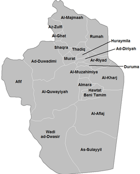
- 01. Riyadh (5,254,560)
- 02. Al Diriyah (73,668)
- 03. Al Kharj (376,325)
- 04. Al Duwadimi (217,305)
- 05. Al Majma'ah (133,285)
- 06. Al Quway'iyah (126,161)
- 07. Wadi Al Dawasir (106,152)
- 08. Al Aflaj (68,201)
- 09. Al Zulfi (69,201)
- 10. Shaqra (40,541)
- 11. Howtat Bani Tamim (43,300)
- 12. Afif (77,978)
- 13. Al Sulayyil (36,383)
- 14. Dhurma (24,429)
- 15. Al Muzahimiyah (39,865)
- 16. Rumah (28,055)
- 17. Thadiq (17,165)
- 18. Huraymila (15,324)
- 19. Al Hariq (14,750)
- 20. Al Ghat (14,405)
Makkah Province
Madinah Province
Qassim Province
- 40. Buraydah (614,093)
- 41. Unaizah (163,729)
- 42. Al Rass (133,482)
- 43. Al Mithnab (44,043)
- 44. Al Bukayriyah (57,621)
- 45. Al Badayea (57,164)
- 46. Al Asyah (26,336)
- 47. Al Nabhaniyah (47,744)
- 48. Uyun Al Jiwa (26,544)
- 49. Riyadh Al Khabra (34,497)
- 50. Al Shimasiyah (10,605)
Eastern Province
- 51. Al Dammam (904,597)
- 52. Al Ahsa (1,063,112)
- 53. Hafar Al Batin (389,993)
- 54. Jubail (378,949)
- 55. Al Qatif (524,182)
- 56. Al Khobar (578,500)
- 57. Al Khafji (76,279)
- 58. Ras Tanurah (60,750)
- 59. Buqayq (53,444)
- 60. Al Nairyah (52,340)
- 61. Qaryat al-Ulya (24,634)
Asir Province
- 62. Abha (366,551)
- 63. Khamis Mushait (512,599)
- 64. Bisha (205,346)
- 65. Al Namas (54,119)
- 66. Muhayil (228,979) now includes Bareq (60,000) previously in Makkah Province.
- 67. Sarat Abidah (67,120)
- 68. Tathlith (59,188)
- 69. Rojal (65,406) now includes Al Haridhah (18,586) previously in Jazan Province.
- 70. Ahad Rafidah (113,043)
- 71. Dhahran Al Janub (63,119)
- 72. Balqarn (74,391), previously known as Sabt Alalaya.
- 73. Al Majaridah (103,531)
Tabuk Province
Hail Province
- 80. Ha'il (412,758)
- 81. Baqaa (40,157)
- 82. Al Khazaiah (102,588)
- 83. Al Shinan (41,641)
Northern Borders
Jizan Province
- 87. Jizan (157,536)
- 88. Sabya (228,375)
- 89. Abu `Arish (197,112)
- 90. Samtah (201,656)
- 91. Al Harth (18,586)
- 92. Damad (71,601)
- 93. Al Reeth (18,961)
- 94. Baish (77,442)
- 95. Farasan (17,999)
- 96. Al Dayer (58,494)
- 97. Ahad Al Masarihah (110,710)
- 98. Al Edabi (60,799)
- 99. Al Aridhah (76,705)
- 100. Al Darb (69,134)
Najran Province
- 101. Najran (329,112)
- 102. Sharurah (85,977)
- 103. Hubuna (20,400)
- 104. Badr Al Janub (11,117)
- 105. Yadamah (16,851)
- 106. Thar (16,047)
- 107. Khubash (22,133)
- 108. Al Kharkhir (4,015), previously in Eastern Province.
Bahah Province
- 109. Al Bahah (103,411)
- 110. Baljurashi (65,223)
- 111. Al Mandaq (35,629)
- 112. Al Makhwah (70,664)
- 113. Al Aqiq (47,235)
- 114. Qilwah (58,246)
- 115. Al Qara (31,380), ‘the villages’, sometimes referenced by the largest town, Al Atawelah.
Jawf Province
- 116. Sakakah (242,813)
- 117. Qurayyat (147,550)
- 118. Dumat Al-Jandal (49,646)
References
- ↑ Distribution Maps of the 2010 Census, Central Department of Statistics and Information, Ministry of Economy and Planning, Kingdom of Saudi Arabia.
- ↑ Population and Housing Census 2010, Saudi National e-Government Open Data Portal.