Arnold, Nottinghamshire
| Arnold | |
|---|---|
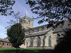 St. Mary's Church | |
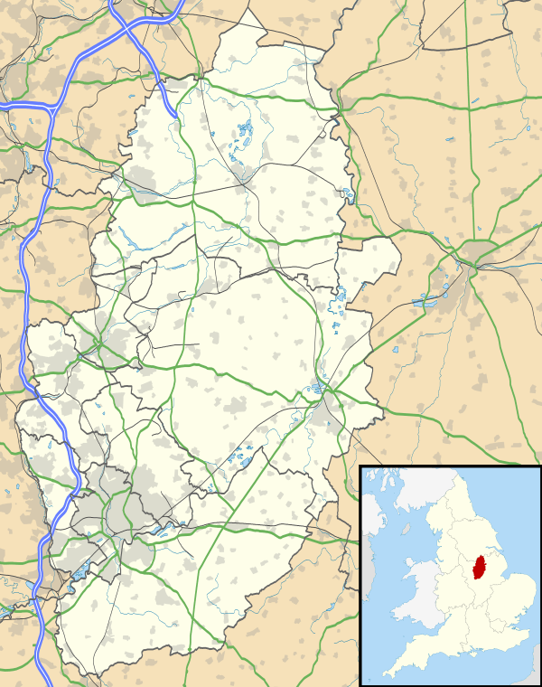 Arnold Arnold shown within Nottinghamshire | |
| Area | 8.148 km2 (3.146 sq mi) |
| Population | 37,768 (2011 census)[1] |
| • Density | 4,635/km2 (12,000/sq mi) |
| OS grid reference | SK 58488 45409 |
| • London | 112.5 mi (181.1 km) |
| Civil parish | |
| District | |
| Shire county | |
| Region | |
| Country | England |
| Sovereign state | United Kingdom |
| Post town | Nottingham |
| Postcode district | NG5 |
| Dialling code | 0115 |
| Police | Nottinghamshire |
| Fire | Nottinghamshire |
| Ambulance | East Midlands |
| EU Parliament | East Midlands |
| UK Parliament | |
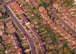
Arnold (/ˈɑːr.nəld/) is a market town,[3][4] unparished area[2] and suburb of the city of Nottingham, in the English ceremonial county of Nottinghamshire. It is situated to the north-east of Nottingham's city boundary, and is in the local government district of Gedling. Since 1968 Arnold has had a market, and the town used to have numerous factories associated with the hosiery industry. Arnold's town centre is the largest in Gedling Borough[5] (whose headquarters are located in the town)[6] and the most important in the northeastern part of the Greater Nottingham conurbation.[5] Nottinghamshire Police have been headquartered in Arnold[7] since 1979.[8] At the time of the 2011 Census, Arnold had a population of 37,768.[1]
Areas within Arnold include Daybrook, Woodthorpe, Redhill, Warren Hill and Killisick.
Etymology
Arnold was referred to as "Ernehale" in Domesday Book of 1086. This name meant 'place frequented by eagles' or 'the valley of eagles'.[9][10]
A History of Arnold (1913) by Rev. Rupert W. King and Rev. James Russell explains the etymology of Arnold's name thus:
"Heron-hald", meaning the corner of the forest where Herons (large birds) live. Which becomes over the centuries since 500 A.D. by "lazy" pronunciation, Eron-ald, thence Ern-old and Arn-old.
The local topography suggests that Arnold can never have been a haunt of eagles, because they inhabit areas of rocky outcrops, which have formed cliffs: the nearest such location is Creswell Crags, some 20 miles (32 km) north-west as the eagle flies. However, the fish-eating white-tailed eagle (also known as the erne) could have caught fish in the River Trent, which lies 4 miles (6.4 km) south-east of Arnold, on the other side of the Mapperley Plains ridge: these eagles might then have flown north-west in the evenings to roost in the ancient woodland area now known as Arnold. The Anglo-Saxon migrant-invaders, when they arrived along the River Trent from the Humber Estuary c. 500 A.D., might have seen these eagles—which measure 66–94 cm (26–37 in) in length with a 1.78–2.45 m (5.8–8.0 ft) wingspan—flying northwest in the evenings and named this roosting location 'Erne-Halh' or 'Erne-Haugh', meaning 'eagle's nook' or 'eagle's corner'.
Arnold is surrounded by a circular ridge from the north-west around to the south-east and raised ground to the west. The town's bowl-like topography may have given it the etymological feature '-halh' or '-haugh'.
History
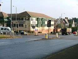
Home Brewery
Building
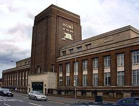
The town's most notable landmark is probably the Home Brewery Company Ltd. building in Daybrook, usually referred to as 'Home Ales' in reference to the Robinson family's Bestwood Home Farm, located on Oxclose Lane.[11] Founded in 1875 by John Robinson, the brewery was famous for its trademark Robin Hood logo on beermats.[12] The brewery remained independent until 1986, when the family owners sold it[12] (along with 450 public houses owned by the brewery) to Scottish & Newcastle for £123million. Scottish & Newcastle gradually ran down production, by subcontracting its brewing to Mansfield Brewery, resulting in the eventual closure of the Daybrook building in 1996.
Dating from 1936, the current building is now officially known as 'Sir John Robinson House' and houses more than 30,000 square feet (2,800 m2) of Nottinghamshire County Council offices. It is located at the junction between the A60 (Mansfield Road) and Sir John Robinson Way,[lower-alpha 1] and its architect was Thomas Cecil Howitt.[15] The Grade II listed building's[16] illuminated 'Home of the Best Ales' sign was altered to remove the word 'Ales' and to include the logo of the county council. The three-storey[lower-alpha 2] building has an unusual 'putti frieze' by sculptor Charles L J Doman along the front wall which depicts groups of putti involved in the brewing of beer.[17] Three designs are repeated in an ABCABC/CBACBA pattern. The reliefs are in a 2:3 proportion and are white casts. 'A' depicts a drinking table; 'B' shows barrel-making; and 'C' illustrates the stirring of the brew—all allegories of the brewing process. The famed[12] decorative ironwork gates and railings are contemporaneous[17] and form part of the listed building.[16]
King George V Park
In 1950 the Home Brewery Company Ltd gave the land for Arnold's King George V Park, a permanent memorial to King George V and guaranteed for free public access in perpetuity for recreation. The Charity Commission held an enquiry that closed in December 2005 into restricted public access.[18] Due to this ruling, Arnold Town F.C. have relocated away from the town centre to another ground in Arnold, known as Eagle Valley.[19] In July 2014, a skatepark costing £110,000 was opened at the playing field.[20]
The Home Ales and Home Brewery brands today
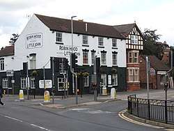
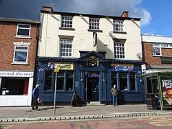
Lincoln Green Brewery of Hucknall, in association with Everards Brewery of Leicester, purchased the Robin Hood pub on the junction of Church Street and Cross Street in 2014, restoring it to its original name of the "Robin Hood and Little John". The pub's history dates back to 1750, and in 2015 it was named as the Campaign for Real Ale (CAMRA) National Cider Pub of the Year, as well as the Nottingham CAMRA Cider Pub of the Year and Nottingham CAMRA Pub of the Year.[21][22] It contains a shrine to the Home Brewery.[23]
The Home Ales brand that once was part of the Home Brewery Co., Ltd. was revived in 2015 by entrepreneur Nick Whitehurst (who used to live in Daybrook near the brewery) after he had acquired a licence from Heineken.[24] Whitehurst—who, through his company Why Not! Think People Limited and its association with Heineken—was able to register a new company called 'Home Ales Drinks Limited' from where he now runs the revived Home Ales brand (established in April 2015). However, the ales are not brewed in Nottinghamshire, instead being produced by Oldershaw Brewery,[24] which is located in the village of Barkston near Grantham in Lincolnshire.[25]
Company
29 August 1890 saw the incorporation at Companies House of the Home Brewery Company Limited. The company was re-registered as a public limited company named Home Brewery plc on 2 April 1982. On 7 April 2014 the company returned to its original legal status as a private company upon its incorporation as Home Brewery Limited. The company is currently still under the ownership of Heineken UK, with a status at Companies House that is Active but classified as a non-trading company.
Framework knitting industry
Arnold was a centre of the framework knitting industry in the 19th century. It was the site of the first framebreaking incidents of the Luddite riots, on 11 March 1811, when 63 frames were smashed.[26][27] The Luddite riots were a response by workers to decreasing pay, standard of living and conditions of employment in the industry as a result of changing fashions decreasing demand for their style of hosiery.
Arnot Hill House and park
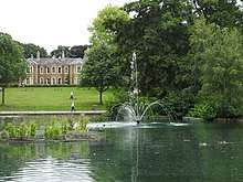
Arnot Hill House was the home John Hawksley and Mary Whittle and the birthplace of Thomas Hawksley. John Hawksley owned a worsted mill in the 1790s, adjacent to the house in Daybrook. Thomas and his son, grandson and great grandson were civil engineers specialising in public water supplies.[28] Thomas Hawksley addressed the problem of endemic cholera in Nottingham by introducing a gravity fed pressurised water system, and the use of filtration beds. This reduced the annual cholera death that has reached 289 in 1832 to 13.[28]
Railway
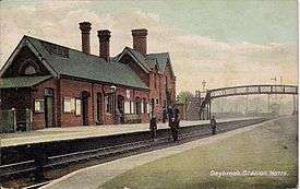
Arnold once had a railway station known as 'Daybrook and Arnold' or simply 'Daybrook railway station'. It was closed along with the rest of the line on 4 April 1960. The station was located on Mansfield Road (A60) on what is now a retail park. There is still evidence of the line in the form of remnants of the embankments on Arnot Hill Park (just behind GO Outdoors). In Peggy's Park (next to Edwards Lane Community Centre), decorative markings commemorate the existence of the line by showing the place where it ran.
The line was the Great Northern Main Line (later nicknamed 'the back route'), with trains to Gedling and Netherfield with the terminus being Nottingham Victoria. Just after those embankments a later built railway—the Nottingham Suburban Railway—joined it and ran over Thackerays Lane on a bridge on its way to Woodthorpe Park and beyond.[29]
Churches
- Arnold
St. Mary's Church, of the Church of England, is believed to date from 1176.[30] It is located on Church Lane[31][32] and is a Grade II* listed building.[16][33]
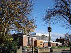
The Grade II* listed[16][34] Roman Catholic Church of the Good Shepherd's current building on Thackerays Lane[31][32] was built in 1964, its modern architecture – featuring a detached spire-cum-belfry[35] – winning an award from the Royal Institute of British Architects in 1966.[36]
The King's Church, formed in 1987 as Kingswell Christian Fellowship by attendants of Cornerstone Church, meets at The King's Centre, which is located on Shirley Drive.[31][37] Originally, the congregation met in a local school and then a day centre for adults with learning disabilities. The church changed its name to The King's Church in 1996. The church purchased, refurbished and extended the former St. Gilbert's Catholic Church building, and the King's Church moved into The King's Centre in 2002.
.jpg)
Designed by Nottingham-based architect William Herbert Higginbottom, Cross Street Baptist Church was opened in 1909, replacing a previous building – dating from 1825 – on the same site.[38] It is situated on Cross Street,[31][32] hence its name.
St. Mark's Church in Woodthorpe belongs to the Church of England and consists of around 8,500 parishioners.[39] It was built in 1961 and consecrated in June 1962.[40] It is located on De Vere Gardens.[32][41]
Arnoldarmy is a Salvation Army corps based on High Street,[31] which runs a second-hand shop called Sally's[42] on Front Street.[43]
Eagle's Nest Church meets on Sundays and is located in Redhill Academy[31][44] on Redhill Road.[45]
Arnold's Kingdom Hall of Jehovah's Witnesses is located on Furlong Street.[32]
Arnold Methodist Church – 'amc' – is situated on Front Street.[31][32][46][47] It is publicly accessible from where Front Street meets the Market Place, and also from the corner of Front Street and Worrall Avenue.
Emmanuel Pentecostal Church is located on Furlong Avenue.[31][32][48]
Arnold United Reformed Church is situated on Calverton Road.[31][49]
Arnold Wesleyan Reform Church is located on Burford Street.[32][50]
- Daybrook
The Church of St. Paul and St. Timothy in Daybrook was designed 1892–1896 by John Loughborough Pearson[51][52] and its construction started in May 1893. In December 1895 the church was completed—except for the 150 feet (46 m)-tall[53] spire and tower,[52] which were added in 1897.[53] The church was originally consecrated in February 1896 in honour of Paul the Apostle,[52] but in 1993 it was re-dedicated as St. Paul's and St. Timothy's when the latter, a daughter church, was opened in Byron Street to replace Cecil Hall (which had long been used as an annexe of St Paul's).[54] The Church of St. Paul and St. Timothy is now a Grade II* listed building[16][55] and is located on Mansfield Road.[31][32]
Daybrook Baptist Church is situated on Mansfield Road.[31][32] Its current building, completed in 1912, was designed by William Herbert Higginbottom.
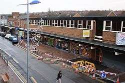
Shopping
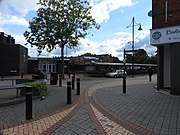
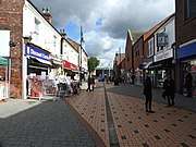
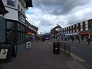
Arnold town centre has a diverse range of restaurants and bars and a choice of shops including supermarkets such as Asda, Sainsbury's and Iceland as well as small independent businesses. There are Aldi and Lidl supermarkets in Daybrook.
Market
1968 saw the opening of Arnold Market in the town centre. Market days are on Tuesdays, Fridays and Saturdays,[3][4] with a flea market being held on Wednesdays.[56] A farmers' market is held on the first Tuesday of each month.[57] It was a private market[58] managed by Janet Surgey (whose deputy was Nigel Wilford)[57] until July 2018, when Gedling Borough Council purchased it from Thurland Estates Ltd.[59]
Recreation
Arnold Leisure Centre, located on High Street at the heart of the town centre, contains a swimming pool and a theatre—called the Bonington Theatre—which was named after the landscape painter Richard Parkes Bonington.[60] The leisure centre was refurbished in 2014[61] at a cost of £1.2 million[62] and changes include the installation of a canopy outside the main entrance, improvements to the Bonington Theatre and bar area as well as major redesigns of the reception area and the changing rooms of the swimming pool.[62]
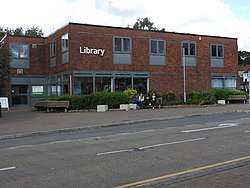
Connected to Arnold Leisure Centre is Arnold Library,[63] which was refurbished in 2015 at a cost of £300,000. The refurbishments improved the library through: the addition of solar panels; the installation of LED lighting; the replacement of windows, heating and ventilation; new shelving; and enhancements to the children's library.[64]
Healthcare
- Arnold
Highcroft Medical Centre is situated on High Street.[65]
Stenhouse Medical Centre is located on Furlong Street.[66] The practice's first doctor was Dr Daniel Stenhouse, who in 1886 became a general practitioner in Arnold and practised until 1897 from Ebenezer House, which was the old farmhouse at the bottom of Worrall Avenue. Following this, Dr Stenhouse moved to live and practise from Arnold House on Church Street until his death in 1916. Before Drs Graham, Jacobs and Lobb formed a partnership due to the expansion of the practice in the 1950s, there had been a succession of independent GPs. The practice remained at Arnold House until 1970, when it moved into Arnold Health Centre. April 1991 saw the practice moving into its current building on Furlong Street, on the site of what was called 'The Flying Horse Yard',[67] named after a nearby pub, The Flying Horse, which closed in April 2015 and is now a steakhouse called 'Sprinters'.[68] The practice now has six partners and 12,000 patients.[67]
- Daybrook
Daybrook Medical Practice can be found on Salop Street.[69]
Education
- Primary schools
- Arnbrook Primary School
- Arnold Mill Primary and Nursery School
- Arnold View Primary School
- Arno Vale Junior School
- Burford Primary and Nursery School
- Coppice Farm Primary School
- Good Shepherd Primary Catholic Academy
- Killisick Junior School
- Richard Bonington Primary and Nursery School
- Robert Mellors Primary and Nursery School
- Secondary schools
- Informal education
Arnold has a University of the Third Age (U3A) that meets at Arnold Methodist Church.[70]

Notable people
- Richard Parkes Bonington[60][71] (1802–1828), landscape painter after whom the town's Bonington Theatre is named.
- Thomas Hawksley[72] (1807–1893), civil engineer responsible for major water and sanitary improvements in Nottingham and other parts of the United Kingdom.
- Arthur Henry Knighton-Hammond[73] (1875–1970), painter.
- Andrea Lowe[74] (born 1 January 1975), actress best known for roles in Coronation Street, The Tudors and Ken Loach film Route Irish.[75]
- Alison Snowden[76] (born 4 April 1958), voice actress, producer, and screenwriter.
Bus services
- Nottingham City Transport
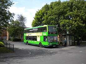
■ 25: Nottingham – Carlton Road – Carlton Hill – Westdale Lane – Mapperley – Arnold[77]
■ 56: Nottingham – Mansfield Road – Plains Estate – Arnold[78][79]
■ 56B: Somersby Road, Arnold – Plains Estate – Front Street, Arnold[78][80]
■ 57: Nottingham – Mansfield Road – Darlton Drive, Plains Estate[78][81]
■ 57X: Nottingham – Mansfield Road – Arno Vale Road – Plains Estate[78][82]
■ 58: Nottingham – Mansfield Road – Arnold – Killsick[78][83]
■ N58: Nottingham – Mansfield Road – Arnold – Killisick – Plains Estate[78][84]
■ 59: Nottingham – Mansfield Road – Arnold – Killsick[78][85]
■ 79: Nottingham – Alfreton Road – Nuthall Road – Cinderhill – Bulwell – Rise Park – Warren Hill – Bestwood Park – Arnold[86][87]
■ 79A: Nottingham – Alfreton Road – Nuthall Road – Cinderhill – Bulwell – Rise Park – Top Valley – Bestwood Park – Arnold[86][88]
■ 87: Nottingham – Mansfield Road – City Hospital – Redhill – Arnold[89]
- Nottingham Community Transport
- L9: Bestwood Park – Arnold – City Hospital – Sherwood – Mapperley – Nottingham[90][91]
- L11: Beeston – Bilborough – Bulwell – Arnold[92]
- Trent Barton
- Calverton Connection: Nottingham – Mansfield Road – Arnold – Calverton.[93]
Gallery


See also
References
- Footnotes
- Notes
- 1 2 Brinkhoff, Thomas (7 July 2013). "Arnold (Nottinghamshire)". City Population. Retrieved 13 February 2016.
- 1 2 Langston, Brett (2013). "Nottinghamshire Registration District". UK BMD website. UK BMD. Retrieved 27 April 2014.
- 1 2 "Gedling Borough Guide & Street Plan" (PDF). Gedling Borough Council. Archived from the original (PDF) on 18 July 2013. Retrieved 22 February 2014.
- 1 2 "Arnold Market, a Market in Arnold, Nottinghamshire. Search for Nottinghamshire Markets". Crawbar Ltd. 16 October 2005. Retrieved 22 February 2014.
- 1 2 Greater Nottingham (Broxtowe Borough, Gedling Borough, Nottingham City) Aligned Core Strategies: Part 1 Local Plan (PDF). Nottingham: Broxtowe Borough Council; Gedling Borough Council; Nottingham City Council. 3 September 2014. p. 29. Retrieved 9 October 2018.
- ↑ "Find & Contact Us". gedling.gov.uk. Gedling Borough Council. 2016. Retrieved 13 February 2016.
- ↑ "Force Headquarters, Sherwood Lodge, Arnold, Nottinghamshire, NG5 8PP". nottinghamshire.police.uk. Nottinghamshire Police. Retrieved 9 September 2016.
- ↑ "Our history". nottinghamshire.police.uk. Nottinghamshire Police. Retrieved 9 September 2016.
- ↑ "The Domesday Book Online – Nottinghamshire A-E". The Domesday Book Online. Retrieved 22 February 2014.
- ↑ "Civic Heraldry Of England And Wales-Nottinghamshire (Obsolete)". Civic Heraldry of England and Wales. Retrieved 22 February 2014.
- ↑ Hewitt, John (2015). "Gedling Heritage Guide" (PDF). Gedling Borough Council. p. 2. Retrieved 27 March 2015.
- 1 2 3 Studeny, Richard (2001). "Nottinghamshire breweries - Home Brewery, Daybrook". BBC Nottingham website. BBC. Retrieved 2 September 2014.
- ↑ "Nottinghamshire - Daybrook, Mansfield Road: Home Brewery Co Ltd (closed 1996)". Brewery History Society. Brewery History Society. Archived from the original on 25 January 2014. Retrieved 26 March 2014.
- ↑ "Nottinghamshire: Defunct Brewery Livery". Brewery History Society. Brewery History Society. Retrieved 11 October 2014.
- ↑ Straw, Craig; Davis, Giles (February 2012). "Sir John Robinson House particulars" (PDF). Nottinghamshire County Council website. Nottingham: Innes England. p. 3. Retrieved 11 October 2014.
- 1 2 3 4 5 6 7 Gedling Borough Council Planning and Environment Department Local Plans Section (6 December 2005). "Listed Buildings" (PDF). Gedling Borough Council. Archived from the original (PDF) on 20 March 2013. Retrieved 21 May 2014.
- 1 2 "Public Monuments and Sculpture Association". Retrieved 24 November 2012.
- ↑ Charities Commission Enquiry: King George V Playing Field Arnold - Registered Charity No 700035 Archived 3 October 2006 at the Wayback Machine.
- ↑ Allison, Bob. "Visiting Eagle Valley". arnoldtownfc.co.uk. Arnold Town Football Club. Retrieved 22 May 2014.
- ↑ Ireland, Ben (5 July 2014). "New £110,000 skate park rolls into action". Nottingham Post. Local World. Archived from the original on 10 August 2014. Retrieved 19 July 2014.
- ↑ Kila, Ayo (30 September 2015). "Robin Hood and Little John wins CAMRA's National Cider Pub of the Year". camra.org.uk. Campaign for Real Ale. Retrieved 3 February 2016.
- ↑ Wright, Dee; Kila, Ayo (1 October 2015). "Robin Hood (AND) Little John wins National award". nottinghamcamra.org. Nottingham Campaign for Real Ale. Retrieved 3 February 2016.
- ↑ "Home Ales: Arnold pub has shrine to old brewery". Nottingham Post. Local World. 3 January 2015. Archived from the original on 10 September 2015. Retrieved 3 February 2016.
- 1 2 Blackburn, Peter (8 May 2015). "Nottingham's Home Ales set to return to city after 20 years". Nottingham Post. Local World. Retrieved 6 April 2017.
- ↑ Britton, Tim (2 April 2011). "Contact". oldershawbrewery.com. Barkston Heath: Oldershaw Brewery Ltd. Retrieved 6 April 2017.
- ↑ Beckett, John. "Luddites". The Nottinghamshire Heritage Gateway. Thoroton Society of Nottinghamshire. Retrieved 2 March 2015.
- ↑ "Knitting Together". Knitting Together. 18 December 2003. Archived from the original on 2 April 2015. Retrieved 2 March 2015.
- 1 2 Information (Interpretation board). Arnot Hill Park, Arnold, Nottinghamshire: Nature Sign Design.
- ↑ Swain, Simon (2010). "Nottingham Suburban Railway". Forgotten Relics. Four by Three. Retrieved 27 March 2014.
- ↑ "History". St. Mary's Church, Arnold. Retrieved 22 February 2014.
- 1 2 3 4 5 6 7 8 9 10 11 "Where?". Arnold Churches Together website. Arnold Churches Together. Retrieved 3 February 2016.
- 1 2 3 4 5 6 7 8 9 10 "Churches in Arnold". arnoldnottingham.co.uk. 2014. Archived from the original on 23 February 2016. Retrieved 3 February 2016.
- ↑ Historic England. "CHURCH OF ST MARY (1235987)". National Heritage List for England. Retrieved 21 May 2014.
- ↑ Historic England. "ROMAN CATHOLIC CHURCH OF THE GOOD SHEPHERD (1376603)". National Heritage List for England. Retrieved 21 May 2014.
- ↑ Geograph user 'Oxymoron'. "Catholic Church of the Good Shepherd, Nottingham". Geograph Britain and Ireland. Geograph. Retrieved 21 May 2014.
- ↑ A history of everyday things in England. Vol. 5 p. 29. Marjorie Quennell, Charles Henry Bourne Quennell, S. E. Ellacott. 1965
- ↑ "Contact us". The King's Church website. The King's Church, Arnold. Retrieved 8 April 2014.
- ↑ Mellors, Robert (1913). King, R W; Russell, J, eds. A History of Arnold. p. 132. Retrieved 23 January 2015.
- ↑ Johnson, Michael; Roberts, Matt. "Welcome to St Mark's Woodthorpe". stmarksonline.co.uk. St. Mark's Church. Archived from the original on 27 December 2015. Retrieved 3 February 2016.
- ↑ Leek, Steve; Hardy, Victoria (2015). "St. Mark's Parish Profile 2015" (PDF). stmarksonline.co.uk. St. Mark's Church. Retrieved 3 February 2016.
- ↑ Johnson, Michael (6 May 2014). "Contact Us". stmarksonline.co.uk. St. Mark's Church. Archived from the original on 27 December 2015. Retrieved 3 February 2016.
- ↑ "Who Are We?". arnoldarmy.com. Arnoldarmy. Retrieved 3 February 2016.
- ↑ "Sally's Nottingham". Nottingham.co.uk. Geoware Media Ltd. Retrieved 3 February 2016.
- ↑ "Eagle's Nest Church". searchchurch.co.uk. Search Church. Retrieved 3 February 2016.
- ↑ "Eagle's Nest Church". findachurch.co.uk. UK Church Directory. Retrieved 3 February 2016.
- ↑ "how to find us". arnoldmethodistchurch.org. Arnold Methodist Church. Archived from the original on 8 April 2014. Retrieved 8 April 2014.
- ↑ Draper, Neil. "Arnold Methodist Church". nottinghameastmethodistcircuit.org.uk. Nottingham East Methodist Circuit. Retrieved 3 February 2016.
- ↑ "Emmanuel Pentecostal Church". findachurch.co.uk. UK Church Directory. Retrieved 3 February 2016.
- ↑ "Arnold United Reformed Church". arnold-urc.supanet.com. Archived from the original on 13 April 2016. Retrieved 3 February 2016.
- ↑ "Arnold Wesleyan Reform Church". findachurch.co.uk. UK Church Directory. Retrieved 3 February 2016.
- ↑ Buist, J (1898). "St Paul's Church, Mansfield Road, Daybrook, Arnold, c 1898". Picture the Past. Retrieved 21 May 2014.
- 1 2 3 Gill, Harry (1913). King, R W; Russell, J, eds. A History of Arnold. p. 45. Retrieved 21 May 2014.
- 1 2 "Daybrook - Archaeology". Southwell & Nottingham Church History Project. University of Nottingham. Retrieved 21 May 2014.
- ↑ "Daybrook - Introduction". Southwell & Nottingham Church History Project. University of Nottingham. Retrieved 3 February 2016.
- ↑ Historic England. "CHURCH OF ST PAUL (1236096)". National Heritage List for England. Retrieved 21 May 2014.
- ↑ "Traders face pitch battle to stop the market trade from stalling". Nottingham Post. Local World. 11 March 2014. Archived from the original on 29 January 2015. Retrieved 29 January 2015.
- 1 2 Lewis, Jeremy H. (2 December 2016). "15720162-large" (JPEG image). Nottingham Post. Arnold: Local World. Retrieved 6 April 2017.
- ↑ "Markets". Gedling Borough Council website. Gedling Borough Council. Archived from the original on 16 March 2015. Retrieved 29 January 2015.
- ↑ "Arnold Market officially under new management" (PDF). Nottinghamshire in Focus (282). Burton Joyce. 24 July 2018. p. 9. Retrieved 25 July 2018.
- 1 2 "Arnold". Gedling Borough Council website. Gedling Borough Council. Retrieved 8 April 2014.
- ↑ Ireland, Ben (5 May 2014). "Swimming club homecoming after £1.2 million leisure centre revamp". Nottingham Post. Local World. Archived from the original on 6 May 2014. Retrieved 19 May 2014.
- 1 2 Gedling Borough Council (June 2014). "ARNOLD LEISURE CENTRE IS NOW OPEN!!". ng5 magazine (June - July 2014 issue). ng magazines. p. 43.
- ↑ Gedling Borough Guide & Street Plan. Burrows Communications. 2008. p. 16.
- ↑ "Robin Hood and young bookworms celebrate reopening of Arnold Library". Nottingham Post. Local World. 17 August 2015. Archived from the original on 10 October 2015. Retrieved 3 February 2016.
- ↑ "Contact Details". highcroftsurgery.co.uk. Stericycle. Retrieved 3 February 2016.
- ↑ "Contact Details". stenhousemedicalcentre.co.uk. Stericycle. Retrieved 3 February 2016.
- 1 2 "Practice History". stenhousemedicalcentre.co.uk. Stenhouse Medical Centre. Retrieved 3 February 2016.
- ↑ "Sprinters". whatpub.com. Nottingham: Campaign for Real Ale. 10 January 2016. Retrieved 3 February 2016.
- ↑ "Contact Details". daybrookmedicalpractice.co.uk. SRCL. Retrieved 21 August 2014.
- ↑ Edwards, David (20 January 2013). "Main meetings". arnoldu3a.org. Arnold University of the Third Age. Retrieved 12 February 2016.
- ↑ "Arnold" in Chambers's Encyclopaedia. London: George Newnes, 1961, Vol. 1, p. 633.
- ↑ Institution of Civil Engineers East Midlands. "The Nottingham Thomas Hawksley Civil Engineering Heritage Leaflet" (PDF). Papplewick Pumping Station. p. 1. Archived from the original (PDF) on 6 October 2014. Retrieved 4 October 2014.
- ↑ Frese, Gina (2000). Dow Chemical portrayed: a catalog to accompany an exhibit at the Chemical Heritage Foundation of the Herbert H. and Grace A. Dow Foundation's collection of the art works of Arthur Henry Knighton-Hammond (2nd ed.). Philadelphia, Pa.: Chemical Heritage Foundation. p. 13. ISBN 0941901262. Retrieved 5 September 2014.
- ↑ "DCI Banks: Nottingham actress Andrea Lowe returns for third series of ITV crime drama". Nottingham Post. Local World. 3 February 2014. Archived from the original on 21 February 2014. Retrieved 5 September 2014.
- ↑ "Actress Andrea Lowe on Ken Loach's Route Irish". BBC. 18 March 2011. Retrieved 18 March 2011.
- ↑ Snowden, Alison; Fine, David. "Alison". SnowdenFine.com. Snowden Fine. Archived from the original on 6 October 2014. Retrieved 4 October 2014.
- ↑ "Lilac Line Nottingham > Arnold (Notts)". Nottingham City Transport. Retrieved 22 February 2014.
- 1 2 3 4 5 6 7 "Lime Line NCN Clarendon, Mansfield Road, Sherwood, Arnold". Nottingham City Transport. Retrieved 22 February 2014.
- ↑ "Lime Line Nottingham > Arnold (Notts)". Nottingham City Transport. Retrieved 22 February 2014.
- ↑ "Lime Line". Nottingham City Transport. Retrieved 12 March 2014.
- ↑ "Service 57 on Lime Line". Nottingham City Transport website. Nottingham City Transport. Retrieved 2 April 2014.
- ↑ "Service 57X on Lime Line". nctx.co.uk. Retrieved 9 February 2016.
- ↑ "Lime Line Nottingham > Killisick". Nottingham City Transport. Retrieved 22 February 2014.
- ↑ "Lime Line Nottingham > Daybrook". Nottingham City Transport. Retrieved 22 February 2014.
- ↑ "Lime Line Nottingham > Killisick". Nottingham City Transport. Retrieved 22 February 2014.
- 1 2 Nottingham City Transport (2017). "Turquoise Line". nctx.co.uk. Nottingham City Transport. Retrieved 6 November 2017.
- ↑ Nottingham City Transport (July 2017). "Service 79 on Turquoise Line". nctx.co.uk. Nottingham City Transport. Retrieved 6 November 2017.
- ↑ Nottingham City Transport (July 2017). "Service 79A on Turquoise Line". nctx.co.uk. Nottingham City Transport. Retrieved 6 November 2017.
- ↑ "Purple Line Nottingham > Arnold (Notts)". Nottingham City Transport. Retrieved 22 February 2014.
- ↑ Nottingham Community Transport (26 October 2017). "L9 Nottingham - Sherwood - Bestwood Park". travelineeastmidlands.co.uk. Traveline East Midlands. Retrieved 7 November 2017.
- ↑ Nottingham Community Transport (January 2017). "L9". ct4nottingham.co.uk. Nottingham Community Transport. Retrieved 2 November 2017.
- ↑ Nottingham City Council Public Transport Team (May 2017). "Locallink L11" (PDF). nottinghamcity.gov.uk. Nottingham Community Transport. Retrieved 2 November 2017.
- ↑ "welcome - calverton connection - run by trentbarton". Trentbarton. Retrieved 22 February 2014.
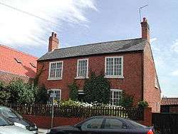
- 1 2 Clarke, Adam (10 September 2008). "34 High Street, Arnold, Nottingham". Retrieved 21 May 2014.
- ↑ Historic England. "34, HIGH STREET (1227482)". National Heritage List for England. Retrieved 21 May 2014.
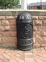
- ↑ Historic England. "BOUNDARY MARK ON ISLAND AT JUNCTION WITH WOODTHORPE DRIVE (1270396)". National Heritage List for England. Retrieved 9 May 2014.
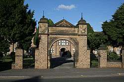
- ↑ Historic England. "DAYBROOK ALMSHOUSES (1227486)". National Heritage List for England. Retrieved 21 May 2014.
External links
- Gedling Borough Council
- Nottingham City Transport
- Nottinghamshire County Council
- 'A History of Arnold' (1913) by Rev. Rupert W. King and Rev. James Russell
- Arnold Local History Group
- Arnold, Nottinghamshire at Curlie (based on DMOZ)
- Arnold in the Domesday Book
Places adjacent to Arnold, Nottinghamshire | |
|---|---|
| Unitary authorities | |
|---|---|
| Boroughs or districts | |
| Major settlements | |
| Topics | |