Archignat
| Archignat | |
|---|---|
| Commune | |
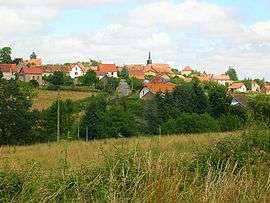 A general view of Archignat | |
 Archignat Location within Auvergne-Rhône-Alpes region  Archignat | |
| Coordinates: 46°22′22″N 2°25′30″E / 46.3728°N 2.425°ECoordinates: 46°22′22″N 2°25′30″E / 46.3728°N 2.425°E | |
| Country | France |
| Region | Auvergne-Rhône-Alpes |
| Department | Allier |
| Arrondissement | Montluçon |
| Canton | Huriel |
| Intercommunality | CC Pays Huriel |
| Government | |
| • Mayor (2014-2020) | Robert Muglia |
| Area1 | 24.35 km2 (9.40 sq mi) |
| Population (2015)2 | 339 |
| • Density | 14/km2 (36/sq mi) |
| Time zone | UTC+1 (CET) |
| • Summer (DST) | UTC+2 (CEST) |
| INSEE/Postal code | 03005 /03380 |
| Elevation |
329–567 m (1,079–1,860 ft) (avg. 359 m or 1,178 ft) |
|
1 French Land Register data, which excludes lakes, ponds, glaciers > 1 km2 (0.386 sq mi or 247 acres) and river estuaries. 2 Population without double counting: residents of multiple communes (e.g., students and military personnel) only counted once. | |
Archignat (occitan Archinhat) is a French commune in the Allier department in the Auvergne-Rhône-Alpes region of central France.
The inhabitants of the commune are known as Archignacois or Archignacoises.[1]
Geography
Archignat is located some 12 kilometres (7.5 mi) west by north-west of Montluçon and 6 kilometres (3.7 mi) east of Treignat. Access to the commune is by the D916 road from Montluçon in the east passing through the heart of the commune and the village and continuing to Boussac in the west. There are also the D150 road from the village to Chambérat in the north, the D309 road from the village to the south, the D148 road going west to Saint-Sauvier, and the D150 road going south-west towards Saint-Martinien. The railway from Montluçon passes through the commune with a station just south of the village. Apart from two forests in the north-west and south, the commune is entirely farmland.[2]
La Magieure river passes through the commune from west to east passing south of the village with the Ruisseau du Liat flowing from the south into it forming part of the eastern border of the commune. La Meuzelle river forms part of the northern border of the commune flowing north-east.[2]
The highest point in the Arrondissement of Montluçon is located in the commune at a place called Signal de l'Age (Signal of the Ages) (572 metres (1,877 ft)). From here, on a clear day, the towers of Bourges Cathedral to the north and the Chaîne des Puys and the Monts Dore to the south can be seen.
Neighbouring communes and villages[2]
Places adjacent to Archignat | |
|---|---|
History
The name of Archignat originates from a Latin anthroponym Arcanius (according to Albert Dauzat[3]) or is derived from the oronymic roots cin or Chigne.[4] The form Archiniaco appeared in 1070 and Archignac in the 13th century.
The common resulted from the merger in 1802 of Archignat and Frontenat. Archignat had 758 inhabitants in 1891.
The Terrier de la Mule, 2 kilometres (1.2 mi) from the present town, was the first location of the village: the remains of foundations of a square tower with ditches attest to this assertion but it is not verified.
Administration
List of Successive Mayors[5]
| From | To | Name | Party | Position |
|---|---|---|---|---|
| 1945 | 1977 | Edmond Bardot | ||
| 1977 | 2008 | Jacques Massy | ||
| 2008 | 2014 | Isabelle Binon | ||
| 2014 | 2020 | Robert Muglia |
(Not all data is known)
Demography
In 2013 the commune had 347 inhabitants.[6] The evolution of the number of inhabitants is known from the population censuses conducted in the commune since 1793. From the 21st century, a census of communes with fewer than 10,000 inhabitants is held every five years, unlike larger towns that have a sample survey every year.[Note 1]
| 1793 | 1800 | 1806 | 1821 | 1831 | 1836 | 1841 | 1846 | 1851 |
|---|---|---|---|---|---|---|---|---|
| 428 | 325 | 414 | 456 | 471 | 550 | 614 | 649 | 683 |
| 1856 | 1861 | 1866 | 1872 | 1876 | 1881 | 1886 | 1891 | 1896 |
|---|---|---|---|---|---|---|---|---|
| 641 | 675 | 662 | 664 | 669 | 736 | 737 | 755 | 739 |
| 1901 | 1906 | 1911 | 1921 | 1926 | 1931 | 1936 | 1946 | 1954 |
|---|---|---|---|---|---|---|---|---|
| 664 | 656 | 611 | 589 | 567 | 547 | 505 | 451 | 422 |
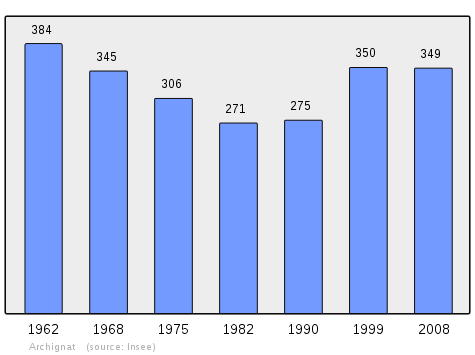
| 1962 | 1968 | 1975 | 1982 | 1990 | 1999 | 2006 | 2009 | 2013 |
|---|---|---|---|---|---|---|---|---|
| 384 | 345 | 306 | 271 | 275 | 350 | 348 | 351 | 347 |
Sources : Ldh/EHESS/Cassini until 1962, INSEE database from 1968 (population without double counting and municipal population from 2006)
Distribution of Age Groups
Percentage Distribution of Age Groups in Archignat and Allier Department in 2010
| Archignat | Archignat | Allier | Allier | |
|---|---|---|---|---|
| Age Range | Men | Women | Men | Women |
| 0 to 14 Years | 28.5 | 21.2 | 16.8 | 14.7 |
| 15 to 29 Years | 15.1 | 17.6 | 15.4 | 13.6 |
| 30 to 44 Years | 22.6 | 21.8 | 18.5 | 17.2 |
| 45 to 59 Years | 16.1 | 20.6 | 21.9 | 20.9 |
| 60 to 74 Years | 13.4 | 9.7 | 17.2 | 17.8 |
| 75 to 89 Years | 4.3 | 9.1 | 9.5 | 14.1 |
| 90 Years+ | 0.0 | 0.0 | 0.6 | 1.7 |
Sources:
Sites and Monuments
- The Girauds Stones.
- The Plaids Stones.
- The Cross of Ages (15th century)

- The Church of Saint-Sulpice from the 13th and 19th century. The church contains a Commemorative Plaque by William of Aaures (15th century)

- The Church of Saint-Pardoux at Frontenat (Middle Ages)
- A disused Fountain near the church at Frontenat surmounted by a niche containing a reliquary bust dedicated to Saint Peter.
- The Lapidary testament of William of Aaures dating from 1416 is located in the Archignat church. the Lordship of Aaures was on the territory of the commune.
- A Mound at Malleret (or Mallereix): the circular mound is about 25m in diameter with a double moat around it.
- The Choux Chalet (free guided tour by appointment).
Picture Gallery
 The Girauds Stones.
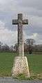 The Cross of Ages.
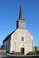 The Church of Saint-Sulpice at Archignat.
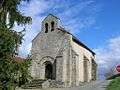 The Church of Saint-Pardoux at Frontenat.
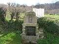 The Disused Fountain.
 The Choux Chalet.
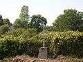 The Bonnet Wayside Cross.
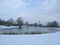 "La Pêcherie" artificial lake under snow.
Sports and Recreation
- Fitness trail
- Mini-golf
- Tennis courts
- Hiking trails
- Skating rink
- Football and Basketball field
- Bowling Alley
- Fishing Lake "La Pêcherie"
See also
External links
- Archignat on the National Geographic Institute website (in French)
- Archignat on Lion1906
- Archignat on Google Maps
- Archignat on Géoportail, National Geographic Institute (IGN) website (in French)
- Archignat on the 1750 Cassini Map
- Archignat on the INSEE website (in French)
- INSEE (in French)
Notes and references
Notes
- ↑ At the beginning of the 21st century, the methods of identification have been modified by Law No. 2002-276 of 27 February 2002 Archived 6 March 2016 at the Wayback Machine., the so-called "law of local democracy" and in particular Title V "census operations" allows, after a transitional period running from 2004 to 2008, the annual publication of the legal population of the different French administrative districts. For communes with a population greater than 10,000 inhabitants, a sample survey is conducted annually, the entire territory of these communes is taken into account at the end of the period of five years. The first "legal population" after 1999 under this new law came into force on 1 January 2009 and was based on the census of 2006.
References
- ↑ "Archignat (03380)". habitants.fr (in French). SARL Patagos. Retrieved 23 January 2016.
- 1 2 3 Google Maps
- ↑ Placenames, origin and evolution; towns and villages--localities--waterways--mountains--places, 1926 (in French)
- ↑ Maurice Piboule in History of communes of Allier. Arrondissement of Montluçon, Roanne, Horvath, 1986, p. 300. (in French)
- ↑ List of Mayors of France
- ↑ "2013 legal populations: Archignat". INSEE (in French). Retrieved 23 January 2016.
- ↑ Ministry of Culture, Mérimée PA00092972 Cross of Ages (in French)
- ↑ Ministry of Culture, Palissy PM03000011 Commemorative Plaque (in French)
- ↑ Ministry of Culture, Mérimée PA00092973 Church of Saint-Pardoux (in French)
| Wikimedia Commons has media related to Archignat. |