Saint-Ennemond
| Saint-Ennemond | ||
|---|---|---|
| Commune | ||
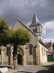 The church in Saint-Ennemond | ||
| ||
 Saint-Ennemond Location within Auvergne-Rhône-Alpes region  Saint-Ennemond | ||
| Coordinates: 46°40′37″N 3°25′24″E / 46.6769°N 3.4233°ECoordinates: 46°40′37″N 3°25′24″E / 46.6769°N 3.4233°E | ||
| Country | France | |
| Region | Auvergne-Rhône-Alpes | |
| Department | Allier | |
| Arrondissement | Moulins | |
| Canton | Yzeure | |
| Intercommunality | Moulins | |
| Government | ||
| • Mayor (2014–2020) | Jean-Claude Lefebvre[1] | |
| Area1 | 38.08 km2 (14.70 sq mi) | |
| Population (2013)2 | 652 | |
| • Density | 17/km2 (44/sq mi) | |
| Time zone | UTC+1 (CET) | |
| • Summer (DST) | UTC+2 (CEST) | |
| INSEE/Postal code | 03229 /03400 | |
| Elevation |
209–258 m (686–846 ft) (avg. 220 m or 720 ft) | |
|
1 French Land Register data, which excludes lakes, ponds, glaciers > 1 km2 (0.386 sq mi or 247 acres) and river estuaries. 2 Population without double counting: residents of multiple communes (e.g., students and military personnel) only counted once. | ||

Saint-Ennemond is a commune in the Allier department in Auvergne-Rhône-Alpes in central France. The Village is located on the border of the Nièvre department, bordered by the villages Lucenay-lès-Aix and Dornes. The town is named after Saint Ennemond, bishop of Lyon in the 6th century. During the revolutionary period(1792-1795), the town took the name of Labron.[2] The mayor is Jean-Claude Lefebvre.[1]
The coat of arms of the municipality is a Coupé au 1) Vert with the Golden Boar, 2nd) party Gules a chevron and silver bell mouths.
Population

Saint-Ennemond population
| Historical population | ||
|---|---|---|
| Year | Pop. | ±% |
| 1793 | 577 | — |
| 1800 | 592 | +2.6% |
| 1821 | 623 | +5.2% |
| 1831 | 601 | −3.5% |
| 1841 | 632 | +5.2% |
| 1861 | 783 | +23.9% |
| 1872 | 906 | +15.7% |
| 1881 | 1,114 | +23.0% |
| 1981 | 1,157 | +3.9% |
| 1896 | 1,175 | +1.6% |
| 1901 | 1,019 | −13.3% |
| 1911 | 982 | −3.6% |
| 1921 | 847 | −13.7% |
| 1931 | 826 | −2.5% |
| 1946 | 828 | +0.2% |
| 1954 | 802 | −3.1% |
| 1962 | 827 | +3.1% |
| 1962 | 827 | +0.0% |
| 1968 | 827 | +0.0% |
| 1975 | 658 | −20.4% |
| 1982 | 671 | +2.0% |
| 1990 | 649 | −3.3% |
| 1999 | 617 | −4.9% |
| 2008 | 655 | +6.2% |
| 2012 | 649 | −0.9% |
| 2013 | 652 | +0.5% |
| Source: INSEE (1968–2013) 2008,[3] 2012,[4] and 2013[5] | ||
See also

Map of Saint-Ennemond.
References
- 1 2 "Liste nominative des communes de l'Allier" [Nominative list of communes of Allier] (PDF) (in French). Association of Mayors and Presidents of Communities of Allier. 23 November 2015. Archived from the original (PDF) on 3 April 2016. Retrieved 22 March 2016.
- ↑ St Ennemond facts.
- ↑ http://www.insee.fr/fr/ppp/bases-de-donnees/recensement/populations-legales/commune.asp?depcom=03229&annee=2008
- ↑ "Populations légales 2013 - Insee". www.insee.fr. Retrieved 20 April 2018.
- ↑ "Populations légales 2013 - Insee". www.insee.fr. Retrieved 20 April 2018.
| Wikimedia Commons has media related to Saint-Ennemond. |
This article is issued from
Wikipedia.
The text is licensed under Creative Commons - Attribution - Sharealike.
Additional terms may apply for the media files.