Barberier
| Barberier | |
|---|---|
| Commune | |
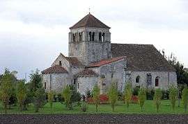 The old Church of Saint André | |
 Barberier Location within Auvergne-Rhône-Alpes region  Barberier | |
| Coordinates: 46°13′08″N 3°14′48″E / 46.2189°N 3.2467°ECoordinates: 46°13′08″N 3°14′48″E / 46.2189°N 3.2467°E | |
| Country | France |
| Region | Auvergne-Rhône-Alpes |
| Department | Allier |
| Arrondissement | Moulins |
| Canton | Gannat |
| Intercommunality | Pays Saint-Pourcinois |
| Government | |
| • Mayor (2014–2020) | Philippe Château |
| Area1 | 8.08 km2 (3.12 sq mi) |
| Population (2013)2 | 133 |
| • Density | 16/km2 (43/sq mi) |
| Time zone | UTC+1 (CET) |
| • Summer (DST) | UTC+2 (CEST) |
| INSEE/Postal code | 03016 /03140 |
| Elevation |
254–290 m (833–951 ft) (avg. 269 m or 883 ft) |
|
1 French Land Register data, which excludes lakes, ponds, glaciers > 1 km2 (0.386 sq mi or 247 acres) and river estuaries. 2 Population without double counting: residents of multiple communes (e.g., students and military personnel) only counted once. | |
Barberier is a commune in the Allier department in the Auvergne-Rhône-Alpes region of central France.[1]
Geography
Barberier is located some 17 km (11 mi) north-west of Vichy and some 17 km (11 mi) north by north-east of Gannat. Access to the commune is by the D36 road from Étroussat in the west which passes through the centre of the commune and the village and continues east to join the D2009 east of the commune. The D183 comes from Bayet in the north and also passes through the centre of the commune, intersecting the D36 at the village, continuing south to join the D66 south of the commune. Apart from the village there are the hamlets of Les Varennes in the south, La Grange Neuve in the east, and Bompré in the north.[2][3]
The Sioule river flows north along the south-eastern border of the commune and continues north to join the Allier north-east of Contigny.[2]
Neighbouring communes and villages[2] | |
|---|---|
History
Barberier appears as Barbrier on the 1750 Cassini Map[4] and the same the 1790 version.[5]
Administration
| From | To | Name | Party | Position |
|---|---|---|---|---|
| 2001 | 2014 | Claude Pornin | ||
| 2014 | 2020 | Philippe Château[7] |
(Not all data is known)
Demography
In 2013 the commune had 133 inhabitants.[8] The evolution of the number of inhabitants is known from the population censuses conducted in the commune since 1793. From the 21st century, a census of communes with fewer than 10,000 inhabitants is held every five years, unlike larger communes that have a sample survey every year.[Note 1]
| 1793 | 1800 | 1806 | 1821 | 1831 | 1836 | 1841 | 1846 | 1851 |
|---|---|---|---|---|---|---|---|---|
| 310 | 341 | 371 | 379 | 411 | 396 | 368 | 352 | 387 |
| 1856 | 1861 | 1866 | 1872 | 1876 | 1881 | 1886 | 1891 | 1896 |
|---|---|---|---|---|---|---|---|---|
| 381 | 421 | 364 | 365 | 373 | 337 | 314 | 334 | 327 |
| 1901 | 1906 | 1911 | 1921 | 1926 | 1931 | 1936 | 1946 | 1954 |
|---|---|---|---|---|---|---|---|---|
| 303 | 295 | 283 | 287 | 246 | 271 | 221 | 255 | 225 |
| 1962 | 1968 | 1975 | 1982 | 1990 | 1999 | 2006 | 2010 | 2013 |
|---|---|---|---|---|---|---|---|---|
| 207 | 170 | 125 | 106 | 108 | 107 | 118 | 131 | 133 |
Sources : Ldh/EHESS/Cassini until 1962, INSEE database from 1968 (population without double counting and municipal population from 2006)

Sites and monuments
There are two sites in the commune that are registered as historical monuments:
See also
Bibliography
- Raymond d'Azémar, Étroussat, Barberier. Municipal Chronicles from the Revolution to today, Montluçon, 1983 (in French)
Notes and references
Notes
- ↑ At the beginning of the 21st century, the methods of identification have been modified by Law No. 2002-276 of 27 February 2002 Archived 6 March 2016 at the Wayback Machine., the so-called "law of local democracy" and in particular Title V "census operations" allows, after a transitional period running from 2004 to 2008, the annual publication of the legal population of the different French administrative districts. For communes with a population greater than 10,000 inhabitants, a sample survey is conducted annually, the entire territory of these communes is taken into account at the end of the period of five years. The first "legal population" after 1999 under this new law came into force on 1 January 2009 and was based on the census of 2006.
References
- ↑ Barberier on Lion1906
- 1 2 3 Barberier on Google Maps
- ↑ Barberier on the Géoportail from IGN (in French)
- ↑ Barbrier on the 1750 Cassini Map
- ↑ Barbrier on the 1790 Cassini Map
- ↑ List of Mayors of France (in French)
- ↑ "Liste nominative des communes de l'Allier (avec maire, arrondissement et canton)" [Nominative list of communes of Allier (with mayor, arrondissement and canton)] (PDF). Association of Mayors and Presidents of Communities of Allier. 1 April 2015. Archived from the original (PDF) on 18 May 2015. Retrieved 13 May 2015.
- ↑ "Legal populations - Barberier". INSEE (in French). Retrieved 24 January 2016.
- ↑ Ministry of Culture, Mérimée PA00093381 Château of Bompré (in French)
- ↑ Ministry of Culture, Mérimée PA00092982 Church of Saint André (in French)

| Wikimedia Commons has media related to Barberier. |