Bamba, Gao Region
| Bamba | |
|---|---|
| Commune and town | |
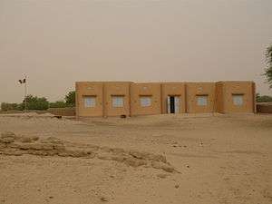 Bamba town hall | |
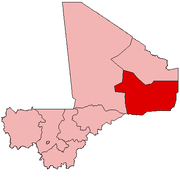
 Bamba Location in Mali | |
| Coordinates: 17°02′N 1°24′W / 17.033°N 1.400°WCoordinates: 17°02′N 1°24′W / 17.033°N 1.400°W | |
| Country |
|
| Region | Gao Region |
| Cercle | Bourem Cercle |
| Area[1] | |
| • Total | 4,776 km2 (1,844 sq mi) |
| Population (2009 Census)[2] | |
| • Total | 28,524 |
| • Density | 6.0/km2 (15/sq mi) |
| Time zone | UTC+0 (GMT) |
Bamba is a small town and rural commune in the Bourem Cercle of the Gao Region of Mali. The town is located on the left (north) bank of the Niger River, 190 km east of Timbuktu and 230 km northwest of the town of Gao. In the 2009 census the commune had a population of 28,524.
The commune of Bamba includes 19 villages and 7 nomadic population groups. The population are primarily Songhais but also Tuaregs and Bozos.
Ted Joans wrote a poem to "Le fou de Bamba" (The madman of Bamba).
References
- ↑ Schéma Directeur de Lutte Contre l’Ensablement dans le Nord du Mali (6ème et 7ème Régions): Monographie de la Commune de Bamba (PDF) (in French), Ministère de l’Environnement et de l’Assainissement, République du Mali, 2004, archived from the original (PDF) on 2011-07-22
- ↑ Resultats Provisoires RGPH 2009 (Région de Gao) (PDF) (in French), République de Mali: Institut National de la Statistique, archived from the original (PDF) on 2011-07-22 .
External links
- Plan de Sécurité Alimentaire Commune de Bamba 2005-2009 (PDF) (in French), Commissariat à la Sécurité Alimentaire, République du Mali, USAID-Mali, 2006, archived from the original (PDF) on 2012-04-29 .
This article is issued from
Wikipedia.
The text is licensed under Creative Commons - Attribution - Sharealike.
Additional terms may apply for the media files.