Andover Hills, Lexington
| Andover Hills | |
|---|---|
| Neighborhood of Lexington, Kentucky | |
| Country | United States |
| State | Kentucky |
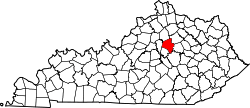
| County | Fayette |
| City | Lexington |
| Area | |
| • Total | 0.469 sq mi (1.21 km2) |
| • Water | 0.0 sq mi (0.0 km2) |
| Population (2000) | |
| • Total | 1,143 |
| • Density | 2,436/sq mi (941/km2) |
| Time zone | UTC-5 (Eastern (EST)) |
| • Summer (DST) | UTC-4 (EDT) |
| ZIP code | 40509 |
| Area code(s) | 859 |
Andover Hills is a neighborhood in southeastern Lexington, Kentucky, United States. Its boundaries are Todds Road to the east, Hays Boulevard to the south, Jacobson Park to the west, and Mapleleaf Park to the north.[1]
Neighborhood statistics
- Area: 0.469 square miles (1.21 km2)
- Population: 1,143
- Population density: 2,436 people per square miles
- Median household income: $61,004[1]
References
- 1 2 Andover Hills Neighborhood Profile Retrieved 2013-02-23.
External links


Coordinates: 37°59′44″N 84°24′48″W / 37.9955°N 84.4133°W
This article is issued from
Wikipedia.
The text is licensed under Creative Commons - Attribution - Sharealike.
Additional terms may apply for the media files.