Amsterdam–Rhine Canal
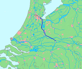
Map of the Amsterdam–Rhine Canal
The Amsterdam–Rhine Canal (Dutch: Amsterdam-Rijnkanaal) is a canal in the Netherlands that was built to connect the port and capital city of Amsterdam to the main shipping artery of the Rhine. Its course follows a generally southeasterly direction as it goes through the city of Utrecht towards Wijk bij Duurstede where it intersects the Lek branch of the Rhine and then continues on to the river Waal near Tiel, with a branch, the Lek Canal, to the Lek near Nieuwegein.
Bridges
Rail bridges (with nearest train station on the west and east bank):
- between Diemen/Diemen-Zuid and Weesp
- between Maarssen and Utrecht Centraal
- between Vleuten and Utrecht Centraal
- between Culemborg and Houten
- between Tiel and Kesteren
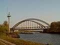 Utrecht, de Demkabrug across the canal
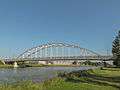 Utrecht, de Meernbrug across the canal
 the canal near Rijswijk (Gelderland)
Coordinates: 52°9′8″N 5°0′23″E / 52.15222°N 5.00639°E
This article is issued from
Wikipedia.
The text is licensed under Creative Commons - Attribution - Sharealike.
Additional terms may apply for the media files.