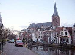
Maarssen
| Maarssen | |||
|---|---|---|---|
| Town and former municipality | |||
 | |||
| |||
 | |||
| Coordinates: 52°08′07″N 5°02′29″E / 52.135144°N 5.041297°ECoordinates: 52°08′07″N 5°02′29″E / 52.135144°N 5.041297°E | |||
| Country | Netherlands | ||
| Province | Utrecht | ||
| Municipality | Stichtse Vecht | ||
| Area(2006) | |||
| • Total | 30.86 km2 (11.92 sq mi) | ||
| • Land | 27.20 km2 (10.50 sq mi) | ||
| • Water | 3.66 km2 (1.41 sq mi) | ||
| Population (1 January, 2007) | |||
| • Total | 39,363 | ||
| • Density | 1,447/km2 (3,750/sq mi) | ||
| Source: CBS, Statline. | |||
| Time zone | UTC+1 (CET) | ||
| • Summer (DST) | UTC+2 (CEST) | ||
| Website | www.stichtsevecht.nl | ||

Maarssen (![]()
On January 1, 2011 Maarssen merged with the councils of Breukelen and Loenen to become Stichtse Vecht.
Population centres
The former municipality of Maarssen consisted of the following cities, towns, villages and/or districts:
- Maarssen (colloquially "Maarssen-dorp") and Maarssen-Broek
- Maarssenbroek
- Maarsseveen
- Molenpolder
- Oud-Maarsseveen
- Oud-Zuilen
- Tienhoven
Transportation
References
- ↑ Statistics are taken from the SDU Staatscourant Archived 2006-02-19 at the Wayback Machine.
External links
- Template:Official website (Stichtse Vecht)
- Regio Maarssen
- Historische Kring Maarssen
- Maarssen 2000
| Wikimedia Commons has media related to Maarssen. |
This article is issued from
Wikipedia.
The text is licensed under Creative Commons - Attribution - Sharealike.
Additional terms may apply for the media files.