Huai Yot District
| Huai Yot ห้วยยอด | |
|---|---|
| Amphoe | |
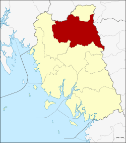 Amphoe location in Trang Province | |
| Coordinates: 7°47′6″N 99°38′6″E / 7.78500°N 99.63500°ECoordinates: 7°47′6″N 99°38′6″E / 7.78500°N 99.63500°E | |
| Country | Thailand |
| Province | Trang |
| Seat | Huai Yot |
| Area | |
| • Total | 753.4 km2 (290.9 sq mi) |
| Population (2005) | |
| • Total | 90,261 |
| • Density | 119.8/km2 (310/sq mi) |
| Time zone | UTC+7 (ICT) |
| Postal code | 92130 |
| Geocode | 9206 |
Huai Yot (Thai: ห้วยยอด, pronounced [hûa̯j jɔ̂ːt]) is a district (amphoe) in the northern part of Trang Province, Thailand.
Geography
Neighboring districts are (from the north clockwise) Ratsada of Trang Province, Thung Song of Nakhon Si Thammarat Province, Pa Phayom and Si Banphot of Phatthalung Province, Mueang Trang and Wang Wiset of Trang Province again and Bang Khan of Nakhon Si Thammarat Province.
History
Originally named Khao Khao (เขาขาว), it was renamed Huai Yot in 1939.[1]
Administration
The district is divided into 16 sub-districts (tambon), which are further subdivided into 133 villages (muban). There are three townships (thesaban tambon): Huai Yot covers parts of tambon Huai Yot and Khao Pun; Na Wong covers parts of tambon Na Wong, Bang Kung, and Wang Khiri; and Lam Phu Ra covers parts of tambon Lam Phu Ra. There are a further 16 tambon administrative organizations (TAO).
|
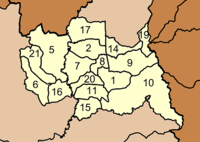 |
Missing numbers are tambon which now form Ratsada district.
References
- ↑ พระราชกฤษฎีกาเปลี่ยนนามอำเภอ กิ่งอำเภอ และตำบลบางแห่ง พุทธศักราช ๒๔๘๒ (PDF). Royal Gazette (in Thai). 56 (ก): 354–364. April 17, 1939.
External links