Bang Khan District
| Bang Khan บางขัน | |
|---|---|
| Amphoe | |
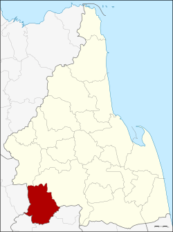 Amphoe location in Nakhon Si Thammarat Province | |
| Coordinates: 8°1′36″N 99°28′24″E / 8.02667°N 99.47333°ECoordinates: 8°1′36″N 99°28′24″E / 8.02667°N 99.47333°E | |
| Country | Thailand |
| Province | Nakhon Si Thammarat |
| Seat | Ban Lamnao |
| Area | |
| • Total | 601.7 km2 (232.3 sq mi) |
| Population (2005) | |
| • Total | 40,498 |
| • Density | 67.3/km2 (174/sq mi) |
| Time zone | UTC+7 (ICT) |
| Postal code | 80360 |
| Geocode | 8017 |
Bang Khan (Thai: บางขัน, pronounced [bāːŋ kʰǎn]) is a district (amphoe) of Nakhon Si Thammarat Province, southern Thailand.
Geography
Neighboring districts are (from the north clockwise) Thung Yai and Thung Song of Nakhon Si Thammarat, Ratsada, Huai Yot and Wang Wiset of Trang Province, and Lam Thap of Krabi Province.
History
The district was created as a minor district (king amphoe) on 1 April 1984, when the three tambon Bang Khan, Ban Lamnao, and Wang Hin were split off from Thung Song District.[1] On 9 April 1992 the minor district was upgraded to a full district.[2]
Administration
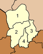
The district is divided into four sub-districts (tambon), which are further subdivided into 60 villages (muban). There are no municipal (thesaban) areas, and three tambon administrative organizations (TAO).
|
 |
References
- ↑ ประกาศกระทรวงมหาดไทย เรื่อง แบ่งท้องที่อำเภอทุ่งสง จังหวัดนครศรีธรรมราช ตั้งเป็นกิ่งอำเภอบางขัน (PDF). Royal Gazette (in Thai). 101 (57 ง): 1278. May 1, 1984.
- ↑ พระราชกฤษฎีกาตั้งอำเภอสอยดาว อำเภอโพนสวรรค์ อำเภอบางขัน อำเภอหว้านใหญ่ อำเภอเมืองปาน อำเภอภูหลวง อำเภอโคกศรีสุพรรณ และอำเภอสำโรง พ.ศ. ๒๕๓๕ (PDF). Royal Gazette (in Thai). 109 (45 ก): 27–29. April 9, 1992.