Ambarawa
| Ambarawa | |
|---|---|
| Town | |
 | |
| Nickname(s): Mbahrowo | |
 Location within Semarang Regency | |
| Country |
|
| Province | Central Java |
| Regency | Semarang Regency |
| Area | |
| • Total | 29,98 km2 (1,158 sq mi) |
| Population (2013) | |
| • Total | 58.990 |
| • Density | 1.967,65/km2 (5.0962/sq mi) |
| Demographics | |
| • Ethnic groups |
Javanese Chinese Bataks |
| Time zone | UTC+7 (Indonesia Western Standard Time) |
| Languages |
Indonesian Javanese |
Ambarawa is a town (and administratively, a subdistrict of the Semarang Regency) located between the city of Semarang and Salatiga in Central Java, Indonesia. Administratively, it is bordered by the subdistricts of Banyubiru to the south, Jambu to the east, Bandungan to the north, and Bawen to the east.
During colonial times, Ambarawa was an important railway hub connecting through regions in Java as far as Yogyakarta and Magelang. The Semarang-Ambarawa-Magelang line was fully operational until 1977. It is the site of the Indonesian Railway Museum (Museum Kereta Api Ambarawa), which features a section of rack railway between Ambarawa to Bedono on the former Ambarawa-Magelang mainline. The 19th-century Fort Willem I penitentiary complex and military barrack is also located in Ambarawa.
Japanese internment camps
Ambarawa was the site of Japanese internment camps where up to 15,000 Europeans had been held during the Japanese occupation during World War II.[1] Following Japanese surrender and the subsequent proclamation of Indonesian independence, fighting broke out in and around Ambarawa on 20 November 1945 between British troops evacuating European internees and Indonesian Republicans.
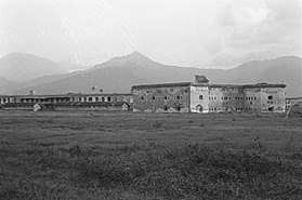 Fort Willem I, circa 1900s-1930s
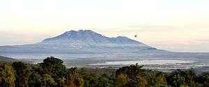
Tourist attractions
References
- ↑ "Introducing Ambarawa". Lonely Planet. Retrieved 12 September 2013.
Ambarawa, 28km south of Semarang, was once the site of a Japanese internment camp where up to 15,000 Europeans were held during WWII.
External links
| Wikivoyage has a travel guide for Ambarawa. |
Tuner, Peter (1997). Java. Melbourne: Lonely Planet. pp. 306–307. ISBN 0-86442-314-4.
- McMillan, Richard (2005). The British Occupation of Indonesia 1945-1946. Melbourne: Routledge. pp. 306–307. ISBN 0-415-35551-6.
- http://dppad.jatengprov.go.id/up3ad-kab-semarang/ (source of population data)