Alport Height
| Alport Height | |
|---|---|
Dec2005.jpg) The Alport Stone, just below the summit of Alport Height | |
| Highest point | |
| Elevation | 314 m (1,030 ft) |
| Coordinates | 53°03′36″N 1°32′47″W / 53.05988°N 1.54636°WCoordinates: 53°03′36″N 1°32′47″W / 53.05988°N 1.54636°W |
| Geography | |
 Alport Height | |
| OS grid | SK305515 |
| Topo map | OS Landranger 119 |
Alport Height is a hill near Wirksworth in Derbyshire. It is a popular picnic site, since it has extensive views to the South, and is the first hill over 1,000 ft (300 m) within easy reach of the Derby area. Like Shining Cliff Woods, 2 km to the east, it is in the care of the National Trust. It was one of their first acquisitions in Derbyshire, acquired in 1930.
It is possible to see Derby city centre from the summit, as well as The Wrekin, the Long Mynd, Clee Hill and the Malvern Hills. On an exceptionally clear day it is also possible to see the Sutton Coldfield and Lichfield masts, and the Birmingham city centre skyline, and also the Lickey Hills just beyond Birmingham.
At night, Pye Green mast can also be seen.
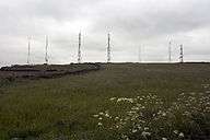
There are eight radio masts and associated buildings in a compound on the summit (not on Trust land).
The hill is sometimes known as Alport Stone after the name of the conspicuous pillar of quarried gritstone, some 20 ft (6.1 m) high, near its summit. The boulder has 3 or 4 recognised climbing routes up it, one being an 8 m route of climbing-grade E5. John Gill's bouldering website has early photographs of pioneer climbers in action on the Stone.[1]
Peaks of the Peak District of England | ||
|---|---|---|
| Marilyns | 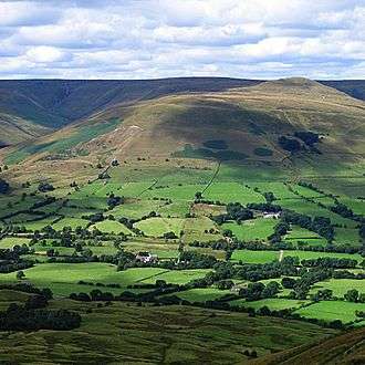 | |
| Other peaks |
| |
References
- ↑ Gill, John. "A Climbing Memoir: 1953–2008". Retrieved 6 January 2017.