Mimasaka, Okayama
| Mimasaka 美作市 | ||
|---|---|---|
| City | ||
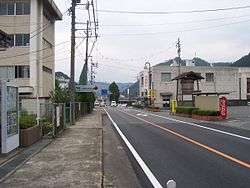 Main street in Ohara Mimasaka | ||
| ||
 Location of Mimasaka in Okayama Prefecture | ||
 Mimasaka Location in Japan | ||
| Coordinates: 35°0′31″N 134°8′55″E / 35.00861°N 134.14861°ECoordinates: 35°0′31″N 134°8′55″E / 35.00861°N 134.14861°E | ||
| Country | Japan | |
| Region | Chūgoku (San'yō) | |
| Prefecture | Okayama Prefecture | |
| Government | ||
| • Mayor | Seiji Hagiwara <萩原誠司> (from March 2014) | |
| Area | ||
| • Total | 429.19 km2 (165.71 sq mi) | |
| Population (March 31, 2017) | ||
| • Total | 28,502 | |
| • Density | 66/km2 (170/sq mi) | |
| Symbols | ||
| • Tree | Prunus mume | |
| • Flower | Erythronium japonicum | |
| Time zone | UTC+9 (JST) | |
| City hall address |
38-2 Sakaemachi, Mimasaka-shi, Okayama-ken 707-8501 | |
| Website |
www | |


Mimasaka city hall
Mimasaka (美作市 Mimasaka-shi) is a city located in Okayama Prefecture, Japan.
As of March 31, 2017, the city has an estimated population of 28,502 (34,338 in 2004) and a population density of 66 persons per km².[1] The total area is 429.19 km².
History
The 16th century village Miyamoto, considered the birthplace of Miyamoto Musashi, is part of present-day Mimasaka.
The modern city of Mimasaka was founded on March 31, 2005 by the merger of the former town of Mimasaka, absorbing the towns of Aida, Ōhara and Sakutō, the village Higashiawakura (all from Aida District), and the town of Katsuta (from Katsuta District).
Geography
- Mountains: Mount Ushiro (the highest mountain in Okayama Prefecture)
- Rivers: Yoshino River, Kajinami River
Adjoining municipalities
Transport
Railways
Road
- Expressways:
- Chūgoku Expressway
- Sakutō Interchange - Narahara Parking Area - Mimasaka Interchange
- Chūgoku Expressway
- National highways:
- Main prefectural roads:
- Okayama Prefectural Route 5 (Sakutō-Ōhara)
- Okayama Prefectural Route 7 (Chizu-Katsuta)
- Okayama Prefectural Route 46 (Wake-Sasame-Sakutō)
- Okayama Prefectural Route 51 (Mimasaka-Nagi)
- Okayama Prefectural Route 86 (Sakutō Interchange)
- Okayama Prefectural Route 90 (Akō-Saeki)
Sister and Friendship cities
- Former Ōhara town
- Former Sakutō town


Notable places and events
- Miyamoto Musashi Budokan
- Yunogo Onsen
- Okayama International Circuit
- Village of Miyamoto Musashi
- Ōhara-shuku (Shukuba)
- Valentine Park Sakutō
- Chōfukuji Temple
- Japan museum of contemporary toy & Hall of music box
 Miyamoto Musashi Budokan
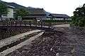 Village of Miyamoto Musashi
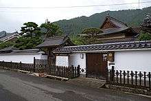 Ōhara-shuku
 Chōfukuji Temple
Notable people from Mimasaka
References
- ↑ "Official website of Mimasaka city" (in Japanese). Japan: Mimasaka City. Retrieved 12 April 2017.
External links
| Wikimedia Commons has media related to Mimasaka, Okayama. |
- Mimasaka City official website (in Japanese)
- 美作国, Dojo Miyamoto Musashi Gleizé (in French)
This article is issued from
Wikipedia.
The text is licensed under Creative Commons - Attribution - Sharealike.
Additional terms may apply for the media files.