Higashiawakura, Okayama
| Higashiawakura 東粟倉村 | |
|---|---|
| Former municipality | |
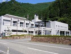 Former Higashiawakura village hall | |
 Higashiawakura Location in Japan | |
| Coordinates: 35°8′45.6″N 134°21′34.4″E / 35.146000°N 134.359556°ECoordinates: 35°8′45.6″N 134°21′34.4″E / 35.146000°N 134.359556°E | |
| Country | Japan |
| Region | Chūgoku |
| Prefecture | Okayama Prefecture |
| District | Aida |
| Merged |
March 31, 2005 (now part of Mimasaka) |
| Area | |
| • Total | 28.01 km2 (10.81 sq mi) |
| Population (2003) | |
| • Total | 1,399 |
| • Density | 49.95/km2 (129.4/sq mi) |
| Symbols | |
| • Tree | Chamaecyparis obtusa |
| • Flower | Rhododendron subg. Hymenanthes |
| • Bird | Japanese bush-warbler |
| Time zone | UTC+9 (JST) |
Higashiawakura (東粟倉村 Higashiawakura-son) was a village located in Aida District, Okayama Prefecture, Japan.
As of 2003, the village had an estimated population of 1,399 and a density of 49.95 persons per km2. The total area was 28.01 km2.
On March 31, 2005, Higashiawakura, along with the towns of Mimasaka (former), Aida, Ōhara and Sakutō (all from Aida District), and the town of Katsuta (from Katsuta District), was merged to create the city of Mimasaka.
Geography
- Mountains: Mount Ushiro (The highest mountain in Okayama Prefecture)
Adjoining municipalities
Education
- Higashiawakura Elementary School
- Ōhara Junior High School (Ōhara)
Transportation
Road
- National highways:
- Prefectural roads:
- Okayama Prefectural Route 556 (Ushiroyama-Kamiishii)
External links
- Official website of Mimasaka in Japanese
This article is issued from
Wikipedia.
The text is licensed under Creative Commons - Attribution - Sharealike.
Additional terms may apply for the media files.