Ahihi-Kinau Natural Area Reserve
Established in 1973, ʻĀhihi-Kīnaʻu Natural Area Reserve includes a coastal lava field and surrounding waters on the southwest coast of the island of Maui, Hawaii. It consists of 1,238 acres (501 ha) on land and 807 acres (327 ha) of ocean along 3 miles (4.8 km) of Maui's southwestern coastline. The reserve includes several popular snorkeling/diving sites and many cultural and geologic sites as well as habitat for numerous rare and endangered species.
The reserve is located at the end of Mākena Road, south of Makena State Park and north of La Perouse Bay at 20°36′18″N 156°26′7″W / 20.60500°N 156.43528°WCoordinates: 20°36′18″N 156°26′7″W / 20.60500°N 156.43528°W.
Climate
Annual rainfall ranges from 15 inches (38 cm) along the coast, to 24 inches (61 cm) along the mauka (upland) boundary. There is distinct seasonal variability in rainfall, with much of the precipitation from winter storms. The highest point in the reserve is Kalua O Lapa at 520 feet (160 m). The deepest water is 115 feet (35 m). Solar radiation here is among the highest in the State. The dark color of the lava absorbs solar radiation creating warmer conditions within the reserve than in surrounding areas (500 calories/m2/day).[1]
Geology
From north to south, the reserve spans four ahupuaʻa (land division extending from the uplands into the sea). These are Onau, Kanahena, Kualapa, and Kalihi. The reserve was named for the land and sea around the lava flow named Cape Kīnaʻu at the southern end of ʻĀhihi Bay.[2]
The reserve's land boundary was specifically designed to encompass the young rugged lava flows on Haleakala volcano’s southwest rift zone. Much of the reserve is barren, rough and jagged ʻaʻa lava with some smooth pahoehoe lava fed by the Kalua O Lapa cinder cone. These lava flows form Cape Kīnaʻu and coat the adjacent sea floor. Also within the reserve is the coastal part of an older, similar sequence of lava flows northwest of Kalua O Lapa. This older sequence, the Kanahena flows, erupted from an unnamed fissure at about 1,400 feet (430 m) altitude.[3]
Five eruptions within the last 500 years are known from East Maui. Kalua O Lapa is among the youngest. Two radiocarbon ages have been determined of charcoal collected from beneath Kalua O Lapa lava and spatter deposits. The average ages indicate the lava flowed sometime between 1419 and 1621 AD. Radiocarbon dating of the Kanahena lava flows leave its age unresolved. The best estimate is between 1024 and 1183 AD.[3]
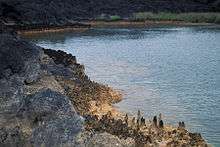
Marine habitat
The coral reefs of the reserve are among the finest in the main Hawaiian Islands. The reefs off of Kanahena were the only Maui reefs to increase coral cover in recent years (17‐30% from 1999‐2006). At least 33 species of coral, 53 species of subtidal invertebrate, and 75 species of fish (17 endemic) were found. Five marine species with protected status frequent the reserve: Hawaiian monk seal or 'ilio‐holo‐i‐ka‐uaua (Monachus schauinslandi); hawksbill turtle or ‘ea (Eretmochelys imbricata); green turtle or honu (Chelonia mydas); spinner dolphin or nai‘a (Stenella longirostris longirostris); and humpback whale or koholā (Megaptera novaeangliae). The marine portion of the reserve is within the Hawaiian Islands Humpback Whale National Marine Sanctuary. The Hawaiian monk seal, hawksbill turtle, and humpback whale are all listed as endangered under the Endangered Species Act (ESA).[4]
Land habitat
The Kalua O Lapa flow created lava tubes and depressions near the shoreline. Some of these depressions extend below sea level, allowing seawater to infiltrate and form shallow ponds. These characteristics created at least four unique native terrestrial habitats: 1) Aeolian (wind-supported) ecosystems on unvegetated lava; 2) Lava tube cave and associated subterranean voids; 3) Littoral (associated with the coast) habitats; and 4) Seabird nesting habitats.
Botanically, the reserve is part of the lowland dry ecotype, although the reserve is not best known for its botanical resources. It is composed almost entirely of unvegetated barren lava. Kipukas (vegetated oases on the lava bed) harbor remnant native plants among the dominant non-native trees. Compared to this ecotype's historical extent on Maui, less than 2% was left as of 2010. Plant life cycles here are keyed to a very severe and prolonged dry season and variable wet season.[5]
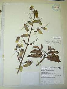
The six native plant communities include naio (Myoporum sandwicense), and maʻo (Gossypium tomentosum) in various kīpuka, or pockets. The endemic wiliwili (Erythrina sandwicensis) is the dominant tree of the remnant native dry forest zone. The natives are imperiled by weeds and feral ungulates such as goats. Twenty-one plant and fourteen animal taxa are native, of which three and five, respectively, are rare.[6] Native insects include blackburn's sphinx moth (Manduca blackburni), the first Hawaiian insect to be listed as endangered under the ESA, in 2003. The reserve includes critical habitat for the moth.[5]
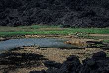
Anchialine pools
Anchialine pools are surface brackish‐water pools, fed underground from both marine and fresh water sources. They lack a surface connection to the sea. The word anchialine is derived from the Greek word “anchialos” meaning close to the sea. Anchialine pools are globally rare. Hawaii is home to the U.S.' only natural representatives as well as the largest concentration of them globally. Cape Kīnaʻu has 12 groupings of pools, including the State's largest. The diversity of shrimp in the pools is the greatest known in the Indo‐Pacific, and five of the ten species are listed as candidate species under the Endangered Species Act (ESA). The pools provide habitat for water, shore, and migratory birds, native herbs and algae. The endangered aeʻo or Hawaiian stilt (Himantopus mexicanus knudseni) forage and nest in at least one of the pool complexes.[4]
Cultural significance
The Reserve includes both pre-European contact and post-contact Hawaiian village sites, heiau (religious sites), burials, trails, shelters, caves, loko iʻa (fish pond) complexes, ranching walls, and a lighthouse site. Nine site complexes are on the Hawaii Register of Historic Places, including the Maonakala Village Complex, Kualapa Cluster and Kauhuoaiakini and Halua Pool Complex. The reserve's cultural and historic sites are protected by Hawaii Revised Statute 13-209-4.[7]
History
Settlements and other development
Permanent settlements of the dry coastal areas of Keoneʻōʻio and ʻĀhihi are thought to have occurred between 1000 and 1400 AD Permanent Hawaiian occupation was based on marine resources and dry-land crops, dominated by ʻuala (sweet potato) cultivation in mauka (mountain) areas. Fish and other marine resources were important staples. The name Keoneʻōʻio refers to the ʻōʻio or bonefish (Albula glossondonta) which was once abundant. In 1786, French explorer La Pérouse noted as many as five villages in the area. These include Maʻonakala village at the far northern end n ʻĀhihi Bay, as well as four small villages in Keoneʻōʻio, each with 10 to 12 thatched houses. Shore dwellers focused primarily on fishing and had access to potable water at shoreline springs. Trade between uplands and coast was frequent.[7]
As European and American merchants, whalers, and missionaries gained influence in the 19th century, traditional society was drawn into global society. Migration and disease contributed to rapid population decline in rural areas. In Honuaʻula, census data showed a decline between 1831 and 1836 from 3,340 to 1,911. By the mid-1840s land use in Honuaʻula transitioned from subsistence to commercial agriculture. An estimated 150 people lived in or near to ʻĀhihi-Kīnaʻu and Keoneʻōʻio in 1853. These changes were associated with changes in land tenure, which eventually allowed "government" lands to become the reserve.[7]
The most prominent and lasting of the Hawaiian government's improvements in the 19th century was the government road built under the direction of Hoapili, governor of Maui from 1823 to 1840. The road connected Honuaʻula to Kaupō along the shore. The road traversed the reserve, and evidently underlies the present and only road. Today the historic road can be seen from Keoneʻōʻio through Kahikinui. The Kanahena Lighthouse was operated on Kanahena Point from 1884 until its replacement opened at nearby Cape Hanamanioa in 1918.[7]
20th century
During World War II, the U.S. Military conducted maneuvers in south Maui, fortifying coastal areas with bunkers. Amphibious landings were made at Mākena. Some of the structures are visible at Oneloa Beach in Mākena State Park, and a concrete ramp from the era at Keoneʻōʻio. In 1945-1946, Cape Kīnaʻu was used for bombing target practice by the Navy. Unexploded ordnance is still present on Cape Kīnaʻu. The reserve’s Kanahena Parking Area (also known as "Dumps") was a dump site for metal debris, such as barbed wire from around the coastline during and after the war. The popular surfing spot in the NAR takes its name from this former dump site.[8]
From 1980 to 2000, Maui's population doubled from 63,000 to 128,000. Including visitors, the number can reach 30-50,000 more. In 1980 the area bordering the reserve (Kīhei to Mākena) hosted 7,263 in a quiet rural area with miles of uncrowded beaches and a few small hotels. Today, Kīhei-Mākena is the second largest tourism area on Maui with a population of more than 22,400, in a 10 miles (16 km) strip of urban/suburban development. With more people and the paving of the road to La Pérouse Bay/Keoneʻōʻio in the 1990s, the reserve and adjacent areas became an increasingly popular destination. In 2001, visitor counts reached 805 people per day and as many as 339 vehicles. As of 2010, the partially closed reserve received an average of 700 visitors per day/250,000 per year.[8]
Natural area reserve
ʻĀhihi-Kīnaʻu was Hawaii's first such reserve, and remains the only one to include both land and marine resources, and the only area on state lands where an entire lava flow is protected from its source to the sea.[1]
Among other protections is a complete, if imperfectly enforced, fishing ban.[6] Because of the extent of unvegetated flow and the lava's extreme roughness and fractured nature, the area is extremely difficult to traverse on foot. Thus, the reserve functions as an outdoor natural history classroom that provides many opportunities to educate and create awareness that the landscape found here is a representative example of the geologic forces that created the Hawaiian archipelago.[3]
ʻĀhihi-Kīnaʻu is one of 19 reserves in Hawaii's Natural Area Reserve System (NARS), which encompasses 109,651 acres (44,374 ha). The Division of Forestry and Wildlife within the Department of Land and Natural Resources (DLNR) administers NARS.[9] TheNatural Area Reserves System provides permanent legal protection for conservation of resource values, one of the highest levels of legal protection for state-managed natural areas in Hawaii. NARS make up 11% of the 1,000,000 acres (400,000 ha) under DLNR jurisdiction. Other types of designation include Wildlife Sanctuary and Forest Reserve. The NAR system’s mission is to: "ensure the stewardship for Hawaii’s unique natural resources through acquisition, active management, and other strategies." Many of the reserves are remote and have few visitors. Conversely, coastal reserves are accessible and can be heavily used by the public. Kaʻena Point on Oʻahu is another such reserve.[10]
Reserve status prohibits removing, injuring, or killing any living thing as well as damaging, disturbing, or removing any geologic artifact or cultural site.[11]
ʻĀhihi-Kīnaʻu trails were poorly marked and little observed. Heavy use was starting to degrade the environment and visitors got injured and lost crossing the lava fields. Attempts to limit or reduce the human impacts while continuing to allow access were not working, according to Bill Evanson of the state Division of Forestry and Wildlife.[12]
Despite these pressures, a 2007 Division of Aquatic Resources survey indicated that the ʻĀhihi-Kīnaʻu coral reef was the only tested reef in Hawaii that was not in decline.[6]
Advisory group
The Advisory Group was formed in 2002 and provides guidance about the reserve and Keoneʻōʻio. For example, DLNR sought the group’s advice on the use of kayaks and commercial activity in the area. The group reflects diverse stakeholder interests and is chaired by the DLNR Deputy Director. Represented groups include educators, Native Hawaiian cultural practitioners, lineal descendants of early residents in the area, landowners, residents, the visitor industry, recreational users, fishers, conservation organizations, and scientists. [13]
DLNR’s Division of Conservation Resources Enforcement (DOCARE) enforces related laws and regulations under implementing legislation HRS Chapter 199. Hawaii's Historic Preservation Division (SHPD) reviews/approves proposed actions that affect historic properties under §6E‐8, HRS, and chapter 13‐275, HAR. SHPD archives the inventory of historic properties and archaeological and historical documents prepared to fulfill the requirements of the State’s historic preservation law.[10]
Management plan goals, objectives and actions
The NAR advisory group has proposed goals, objectives and actions to support the agreed-upon vision that "through kōkua and mālama, respect and protect natural and cultural resources".[14]
| Goal 1. Manage Human (H) Use | Protect natural and cultural heritage, and develop appreciation, understanding, and kuleana through education and interpretation. | ||
| Goal 2. Control Alien (A) Species and Other Biological Threats | Strengthen native biological community and cultural resource integrity by 2015. | Goal 3. Prevent Land-based (L) Impacts | Control and prevent impacts from internal, adjacent and upland source areas that damage habitats, wildlife, and scenic resources. |
| Goal 4. Build and Maintain Management (M) Capacity | Build and maintain the partnerships, infrastructure, and human and financial resources necessary to ensure effective site management. |
Manage human (H) use
Manage human uses to protect natural and cultural heritage, and develop appreciation, understanding, and kuleana for the Reserve through education and interpretation.
H1—Reduce negative visitor impacts and increase safety
By 2012, reduce the frequency of negative impacts caused by visitors by half (from 2007 levels) within priority natural and cultural (terrestrial and marine) resource areas. Continue reductions through 2015.
| Action | Summary | Tasks | Notes |
|---|---|---|---|
| H1(a) | Set and manage visitor limits and access points | Characterize visitor access and activities; establish open and restricted access areas; enforce visitor limits and vehicular quotas; allow parking only at the entry and Kanahena parking area, but not at Kanahena Cove or roadside; enhance management of solid and human waste. | May require NARS rule change |
| H1(b) | Effectively enforce use regulations, by zone. | Work with DOCARE and MPD to enforce regulations, particularly to address illegal fishing, habitat trampling and cultural resource degradation and proper waste disposal; increase fines and penalties as needed; improve awareness of regulations and promote low-impact behavior through informational materials and a “stewardship” program; implement remote surveillance of motorized marine activities, such as submerged acoustic monitoring stations (EARs); gather data to track trends; enforce temporary restrictions when seal or turtle is on shore. | see also Objective H3 |
| H1(c) | Establish and maintain visitor entry and passage systems. | Implement state-of-the-art visitor trail system; establish "interpretive areas"; provide informational materials along self-guided trails, parking lots and access gates; coordinate paid, ranger-guided hikes along established trails; simplify pedestrian/swimmer navigation (particularly within La Pérouse Bay); install visible markers on land and sea; encourage appropriate, low-impact visitor behavior through informational materials and a "stewardship" initiative; establish a marine "trail system" to direct visitors to preferred entry/exit locations and interesting underwater places that will not damgage habitats. | see also Objective H3 |
| H1(d) | Document visitor levels and user behavior | Gather data on visitor levels, behaviors, impacts, and other information. | |
| H1(e) | Adjust boundaries as needed. | Establish a working group from the Advisory Group to review current boundary definitions; recommend boundaries that maximize management effectiveness. | |
| H1 (f) | Minimize the impacts of unexploded ordnance | Work closely with the Army Corp of Engineers to minimize impacts of unexploded ordnance removal to reserve resources, staff and public safety. |
H2—Protect and stabilize cultural resource sites
By 2012 protect, stabilize, and maintain the integrity of at least three high priority cultural resource sites inside and/or adjacent to the Reserve.
| Action | Summary | Tasks | Notes |
|---|---|---|---|
| H2(a) | Identify the most threatened cultural sites | Establish a respected working group composed of cultural practitioners, community leaders, archeologists and historians; assess the threats;[15] document negative visitor impacts; document invasive species impacts, particularly feral ungulates and alien invasive plants; identify sites requiring immediate protection. | |
| H2(b) | Protect high priority cultural resource sites. | Develop a plan to protect identified sites; take site-specific actions, including increasing ranger presence, rerouting pedestrian trails, fencing out feral ungulates and limiting access and behavior; apply for federal designation as priority cultural resource sites | |
| H2(c) | Establish and enforce rules to ensure appropriate visitor behavior | Establish guidance/rules governing appropriate visitor behavior, including penalties; raise visitor awareness of appropriate behavior and cultural resource rules and regulations; enforce regulations in collaboration with DOCARE | see also Objective H3 |
| H2(d) | Inventory internal and adjacent archeological sites | Inventory previously undocumented sites; prepare detailed maps and descriptions of priority and/or high-visitation internal and adjacent sites, including the Keoneʻōʻio anchialine pool/inlet complex and Maʻonakala Village Complex; map and investigate historic uses of subterranean anchialine pool and lava tube systems; make recommendations for preservation and monitoring of on-site and adjacent priority archaeological sites. |
H3—Preserve Knowledge and Promote Awareness of the Reserve
By 2012 increase by 300% the number of knowledgeable/aware visitors and residents from 2007 levels.
| Action | Summary | Tasks | Notes |
|---|---|---|---|
| H3(a) | Establish an information and interpretation program. | Develop an outreach plan which addresses management needs and resource considerations while building a kuleana and mālama ʻāina ethic among visitors and residents; employ professional services to design the themes, messages, content, delivery, etc., and desired outcomes; engage the expertise of the Advisory Group, its working groups, subject matter experts and reserve staff in the planning process. | |
| H3(b) | Implement and operate a volunteer program | Develop a state-of–the-art program to train, supervise, and recognize volunteers | |
| H3(c) | Promote cultural awareness to understand regional significance and establish a sense-of-place | Study archival sources, including stories, songs, maps, Hawaiian language newspapers, and other historic documents; interview and document oral histories of knowledgeable island residents, focusing on lineal descendants with kuleana over reserve lands; document fishing and other resource harvesting/gathering traditions; integrate the material into an interpretive program and training for staff and volunteers. |
Control Alien (A) Species and Other Biological Threats
Strengthen the native biological community and cultural resource integrity of the reserve by 2015 as the result of the successful control of alien species and other biological threats in terrestrial and aquatic habitats.
A1—Control ungulate populations
By 2015, reduce the abundance of feral (goats and pigs) and introduced (deer) ungulates from native terrestrial habitat and cultural sites to 80% of their 2010 population sizes.
A1(c)|| Exclude ungulates from entering the Reserve. || In the short-term, identify representative habitat negatively impacted by ungulates within the Reserve; within three high-priority areas of both forest and shrubland habitat types, immediately exclude ungulates by fencing small enclosures; by 2015, permanently exclude ungulates by fencing the entire Reserve boundary/perimeter. ||
| Action | Description | Tasks | Notes |
|---|---|---|---|
| A1(a) | Improve understanding of ungulate impacts and controls | Survey ungulate populations and assess habitat use patterns and impacts; identify sites with a high potential for native habitat restoration; assess how roads, substrate, stream courses, cultural sites, and other physical factors influence fence line construction; draft environmental impact assessments (EIA), including map of proposed fence line and cost estimate for various fencing scenarios on TMK boundary on lava; | |
| A1(b) | Deter and remove ungulates. | Complete short-term deterrent and removal efforts around impacted priority cultural resource sites within DOFAW guidelines; assess utility and feasibility of employing these controls on a wider scale throughout the Reserve; provide public outreach materials that illustrate the humane nature of ungulate deterrence and removal efforts; install fence per EA and best management practices for terrain and ungulate types; following installation of reserve-wide exclusion fence efforts, remove all ungulates, monitor for any continued ungulate presence. | |
A2—Control priority alien plants and animals in terrestrial habitats
Reduce the population density of top alien invasive (unwelcome) plants and animals by at least 50% by 2015.
| Action | Description | Tasks | Notes |
|---|---|---|---|
| A2(a) | Remove predatory animals from anchialine pool and seabird nesting areas. | Trap and remove rats, mongoose, cats, dogs and cattle egrets that prey on native waterbirds and their eggs, including Kauhioaiakini; remove predators during breeding/brooding season (approx. March–August); monitor ongoing predator activity, bird demography and breeding success; remove predatory mammals at high-priority anchialine pool sites; survey nesting seabirds, employing automated recorders; assess expanding these controls; provide outreach materials that illustrate the humane nature and benefits to native species of predator removal. | |
| A2(b) | Reduce unwelcome plant populations in native habitats. | Clean out three representative areas of high-priority lava flow or shrubland habitat needing active restoration; remove unwelcome sourbush, sour grass, pickle weed, mangrove and woody plants from and around pools; monitor and control recruitment of unwelcome seedlings through time; develop and explore effective methods for landscape monitoring of vegetation structure and composition in lava flow, shrublands, and anchialine areas. | |
| A2(c) | Reduce alien invasive insect populations in native habitats. | Monitor effects of bio-control on unwelcome gall wasps and on wiliwili trees in native forest and shrubland habitat; establish specific management strategies based on results; conduct baseline inventory to document presence/absence of other unwelcome invertebrates. | |
| A2(d) - Prevent new alien introductions. | Establish a mechanism for rapid response to eliminate new introductions at the incipient species level; identify other high priority biological threats for early detection and further study using MISC priority species determinations. Review as needs/discoveries arise and tie to incipient species which are most economically and efficiently controlled. |
A3—Control priority unwelcome organisms in aquatic habitats
Within coral reef and anchialine pool habitat, by 2015 reduce the population density of priority unwelcome fish and aquatic plant species by at least 50%.
| Action | Summary | Tasks | Notes |
|---|---|---|---|
| A3(a) | Remove predatory fish from coral reefs and anchialine pools. | Remove roi (peacock grouper) within a designated removal zone; maintain roi population at low or no individuals; quantify effects of roi removal; relocate introduced marine and brackish water fish species from anchialine pools to adjacent reef areas. | |
| A3(b) | Detect unwelcome algae density and emerging threats on coral reefs and anchialine pools. | Monitor marine intertidal areas for alien algae; monitor anchialine ecosystems for trends including unwelcome species and to inform comparisons to other pool sites in Hawaii; monitor coral bleaching and disease, crown of thorns sea stars (COTS) and marine unwelcome species; rapidly respond to threats. | |
| A3(c) | Investigate the most effective ways to address aquatic unwelcome species and other threats. | Investigate coral and fish health/disease and COTS outbreaks; explore ways to address threats. |
A4—Actively restore native plant and wildlife assemblages
By 2015, successfully implement a native habitat restoration plan that results in the restoration of at least 5 acres within both native shrubland and lava flow habitats.
| Action | Summary | Tasks | Notes |
|---|---|---|---|
| A4(a) | Replant native species at priority test sites in anchialine and shrubland habitat. | Within sites identified in A1(c) and A2(b), reestablish plants with a species composition and diversity that best reflects a native community; monitor and document survivorship rates, species diversity, and successional changes; remove unwelcome plant recruits from test sites. | |
| A4(b) | Implement a native habitat restoration plan. | Characterize the status of native plants, native invertebrates and native wildlife (including spatial extent) and compare results to 1989 baseline survey; develop a native shrubland and lava flow habitat restoration plan; adopt Maui Endangered Seabird Project best management practices; research historical trends regarding biotic and climatic changes within the region and study analogous ecosystems. |
L1—Maintain high coastal water quality
By 2015, meet or exceed class AA water quality standards.
| Action | Summary | Tasks | Notes |
|---|---|---|---|
| L1(a) | Prevent or minimize sources of land-based pollution. | Assess and identify primary contributions of land-based pollution, including nutrient loading and soil erosion from upland development; implement appropriate best management practices to minimize these sources. | |
| L1(b) | Upgrade internal and adjacent sewage systems. | Characterize current sewage holdings and systems; upgrade cesspools to septic tanks; maintain environmentally responsible visitor restroom facilities; explore possible use of alternative sewage system technologies for application. | |
| L1(c) | Educate neighbors on pollutant impacts and reduction efforts. | Reach out to neighbors and residents upland of Class AA waters with relevant messages about reducing pollutant and
nutrient loads, upgrading sewage systems, and other efforts to minimize pollution. | |
| L1(d) | Monitor water quality for coral reefs within the Reserve’s waters. | Monitor water quality; initiate a community volunteer water quality monitoring program; work with volunteers to remove marine debris along the coastline. |
L2—Reduce upland development impacts
By 2015, largely reduce or fully mitigate negative upland development impacts to natural and cultural resources.
| Action | Summary | Tasks | Notes |
|---|---|---|---|
| L2(a) | Ensure best land use management practices within adjacent lands | Assess land ownership interests in a one-mile (1.6 km) zone surrounding the reserve’s boundaries by TMK and land use zoning status; prioritize land management actions according to proximity, feasibility, and potential for resource impacts; minimize land development activities within the zone and seek county and state approval; ensure close scrutiny of Special Management Area (SMA) permit applications in the zone. | |
| L2(b) | Review and influence progress on proposed development projects. | Receive notification of planned development efforts on neighboring lands ; revise permit review process so that development sustains cultural and ecological integrity. | |
| L2(c) | Acquire and hold adjacent lands and infrastructure. | Gain Natural Area Reserves Systems Commission (NARSC) and DLNR support for NAR expansion into eligible adjacent lands through purchase, trade, conservation easements and/or rezoning; discuss acquisition with landowners within the reserve, and with infrastructure (i.e., electric lines) owners about returning to a more natural state over time. |
L3—Prevent or minimize man-made light pollution
By 2015, reduce nighttime light levels within the Reserve to naturally occurring levels so as to prevent alteration or disruption of native wildlife nocturnal behavior.
| Action | Summary | Tasks | Notes |
|---|---|---|---|
| L3(a) | Prevent or minimize sources of manmade light pollution. | Assess whether natural ambient nighttime light levels at boundaries exceed county lighting ordinances; identify sources of light pollution; implement best practices to keep light within legal limits; monitor and maintain ambient nighttimelight levels at/near naturally occurring levels . | |
| L3(b) | Educate neighbors on light pollution. | Explain how light pollution damages the environment and how to minimize it. |
Build and Maintain the Reserve’s Management (M) Capacity
We will build and maintain the partnerships, infrastructure, and human and financial resources necessary to support the Reserve’s capacity to ensure effective site management through time.
M1—Secure and sustain needed human and financial resources
By 2015, secure necessary human and financial resources to fully implement and sustain all minimum and most desired management activities.
| Action | Summary | Tasks | Notes |
|---|---|---|---|
| M1(a) | Implement a sustainable financing plan by 2011. | Outline financing scenarios for minimum, desired, and ideal annual budgets; secure the revenue to meet at least the minimum budget; establish an endowment mechanism for long-term funding | |
| M1(b) | Hire a full-time manager by 2011. | Identify financing for a full-time reserve manager; develop a job description; recruit and hire the best candidate by mid-2011. | |
| M1(c) | Build the technical capacity of the ranger program. | Establish a professional ranger team; assess current team, including biological and human use monitoring skills; adjust team size and capacity; enhance ranger-visitor interactions beyond rule enforcement and monitoring; add regular outreach events with residents; provide volunteer ranger program in both terrestrial and marine settings; train team in cultural sensitivity | see also Objective H3 |
| M1(d) | Establish a Reserve user fee program. | study feasibility; obtain public support; obtain state and county support; implement the user fee and manage revenues generated. | NARS rule change may be required |
| M1(e) | Strengthen the Advisory Group. | Support the group to provide a public forum and to build support for plan implementation; build administrative capacity through member recruitment; obtain administrative and support by partner organizations for quarterly meetings and member training; obtain state and county recognition of the group's responsibilities. |
M2—Provide biological resource status information for management
By 2015 secure the necessary human and financial resources to periodically monitor the status of all priority biological resources.
| Action | Summary | Tasks | Notes |
|---|---|---|---|
| M2(a) | Monitor terrestrial resources. | Periodically monitor native plant assemblages, invertebrates in lava-tube caves, new lava, anchialine pools, littoral areas, and shrublands; monitor seabirds and waterbirds | |
| M2(b) | Monitor aquatic resources. | Support DAR and Coral Reef Assessment and Monitoring Program (CRAMP) at Kanahena Point and Kanahena Cove; monitor marine intertidal areas for ʻopihi, other invertebrates and algae; monitor anchialine aquatic ecosystems. |
M3—Provide on-site infrastructure to meet management needs
By 2014, provide the necessary on-site infrastructure to sustain all minimum and some desired management activities, including vehicles, ranger equipment, trail maintenance equipment, and digital, radio, and telecommunication and office equipment.
| Action | Summary | Tasks | Notes |
|---|---|---|---|
| M3(a) | Complete the Reserve’s facility and infrastructure planning. | By 2011, assess the reserve’s facilities and needs; by 2012, complete a short-term (2012–2015) and long term (2015–2025) facilities and infrastructure masterplan, including visitor access controls and facilities, interpretive and educational programs, and office and equipment space for on-site operations;[16] by 2014, obtain sign-off by state and county authorities; during 2014, implement masterplan. | |
| M3(b) | Improve and maintain access gates and roads. | Obtain a memorandum of agreement (MOA) with state and county authorities on access, maintenance, enforcement, and liability for the road; improve and maintain the Reserve’s roads; install and establish gates and guard/toll stations | see Goal 1 |
| M3(c) | Improve and maintain visitor facilities. | Provide parking, lavatories, informational stations and interpretive areas; install infrastructure to meet digital, radio, and telecommunication needs. | |
| M3(d) | Improve and maintain waste management. | Provide waste management facilities; implement a visitor waste management awareness and education program. | |
| M3(e) | Improve and maintain ranger stations and staff offices. |
M4—Initiate and maintain strategic partnerships
By 2015, recruit and actively engage a full suite of federal, state, county, non-governmental, and community partners in the reserve’s management and financing process.
Partial closure
Starting August 1, 2008, Hawaii closed access to the majority of the reserve, including unofficial trails to Kalua o Lapa, Kalaeloa (popularly known as “the Aquarium”), and Mokuha (also known as “the Fishbowl”). Preserving the anchialine pools was a major focus. Main threats to these wetlands include non-native invasives such as fish or prawns, algal mat formations and human activities.[6]
Access to the reserve's northern portions, which are most used by the public, have remained open. These include Waiala Cove and the coastal area along ʻAhihi Bay including the “Dumps” surf break.[11]
Department of Land and Natural Resources staff monitor the reserve to assess the effects of the closure and estimate the impacts of further protective actions.[11]
The closure was scheduled to end July 31, 2010.[11]
Post-closure
An advisory group recommended extending the closure.
The first draft of the area master plan was released in October, 2010, attempting to balance protection with human activities.[12][17]
DLNR monitors the area's marine, geological and cultural resources to inform the planning process for the reserve. The plan has taken longer than expected to complete, in part because Āhihi-Kinau has so many more cultural and archaeological sites than other Natural Area Reserves, and also because of budget challenges.[12]
Alternatives to full opening include guided hikes, entry permits, or commercial concessions. Much-anticipated guided hikes have been on hold because of spotty communications coverage for emergency radios and cell phones.[12]
References
- 1 2 Division of Forestry and Wildlife 2010, p. 12
- ↑ Division of Forestry and Wildlife 2010, p. 10
- 1 2 3 Division of Forestry and Wildlife 2010, p. 13
- 1 2 Division of Forestry and Wildlife 2010, p. 14
- 1 2 Division of Forestry and Wildlife 2010, p. 15
- 1 2 3 4 "ʻAhihi-Kīnaʻu". State of Hawaii. Archived from the original on 25 November 2016. Retrieved 24 November 2016.
- 1 2 3 4 Division of Forestry and Wildlife 2010, p. 16
- 1 2 Division of Forestry and Wildlife 2010, p. 17
- ↑ "Natural Area Reserves System". State of Hawaii. Archived from the original on 4 November 2016. Retrieved 24 November 2016.
- 1 2 Division of Forestry and Wildlife 2010, p. 19
- 1 2 3 4 "DLNR IMPLEMENTS INCREASED PROTECTION FOR AHIHI-KINAU NATURAL AREA RESERVE" (PDF). State of Hawaii. July 11, 2008. Archived from the original (PDF) on 2010-05-28. Retrieved 2010-04-27.
- 1 2 3 4 "Advisory body: Delay opening of Ahihi-Kinau". The Maui News. April 25, 2010. Archived from the original on 26 April 2010. Retrieved 24 November 2016.
- ↑ Division of Forestry and Wildlife 2010, p. 20
- ↑ Division of Forestry and Wildlife 2010, pp. 63–79
- ↑ utilizing the 2007 Cultural Resources Management Plan
- ↑ taking into account neighboring Mākena State Park Planning considerations and possible Kanaio Natural Area Reserve expansion efforts
- ↑ Division of Forestry and Wildlife (October 20, 2010). ‘Āhihi-Kīna‘u Natural Area Reserve Draft Management Plan (PDF) (Report). Maui, Hawaii: Department of Land and Natural Resources. Archived from the original (PDF) on 15 June 2011. Retrieved 24 November 2016.