Ahar County
| Ahar County شهرستان اهر | |
|---|---|
| County | |
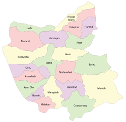 Location in East Azerbaijan Province | |
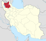
 Location of East Azerbaijan Province in Iran | |
| Coordinates: 38°30′N 47°08′E / 38.500°N 47.133°ECoordinates: 38°30′N 47°08′E / 38.500°N 47.133°E | |
| Country |
|
| Province | East Azerbaijan |
| Capital | Ahar |
| Bakhsh (Districts) | Central District, Hurand District |
| Population (2006) | |
| • Total | 147,781 |
| Time zone | UTC+3:30 (IRST) |
| • Summer (DST) | UTC+4:30 (IRDT) |
| Ahar County can be found at GEOnet Names Server, at this link, by opening the Advanced Search box, entering "9205848" in the "Unique Feature Id" form, and clicking on "Search Database". | |
Ahar County (Persian: شهرستان اهر) is a county in East Azerbaijan Province in Iran. The capital of the county is Ahar.[1] At the 2006 census, the county's population was 147,781, in 34,067 families.[2] The county is subdivided into two districts: the Central District and Hurand District. The county has two cities: Ahar and Hurand.
Castles
References
- ↑ Gitashenasi Province Atlas of Iran
اطلس گیتاشناسی استانهای ایران Archived 2007-05-22 at the Wayback Machine. - ↑ "Census of the Islamic Republic of Iran, 1385 (2006)". Islamic Republic of Iran. Archived from the original (Excel) on 2011-11-11.
| Capital | |||||||||||||||||||||||||||||||
|---|---|---|---|---|---|---|---|---|---|---|---|---|---|---|---|---|---|---|---|---|---|---|---|---|---|---|---|---|---|---|---|
| Districts |
| ||||||||||||||||||||||||||||||
This article is issued from
Wikipedia.
The text is licensed under Creative Commons - Attribution - Sharealike.
Additional terms may apply for the media files.