Afono
| Afono | |
|---|---|
| Village | |
| Afonotele | |
 | |
 Afono | |
| Coordinates: 14°15′51″S 170°39′3″W / 14.26417°S 170.65083°WCoordinates: 14°15′51″S 170°39′3″W / 14.26417°S 170.65083°W | |
| Country |
|
| Territory |
|
| Area | |
| • Total | 1 sq mi (3 km2) |
| Elevation | 85 ft (26 m) |
| Population (2012) | |
| • Total | 601 |
| • Density | 520/sq mi (200/km2) |
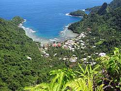
Afono is a village on the northeast coast of Tutuila Island, American Samoa. One of the island's more populous villages, it is located on the edge of Afono Bay, at the eastern edge of the National Park of American Samoa. It is connected by Highway 6 to Vatia, which lies along the coast to the northwest, and to Aua, on the edge of Pago Pago Harbor to the south via a winding stretch of highway which crosses the spine of the island.
Geography
Afono is a village on the north shore of Tutuila Island in American Samoa, located by Afona Bay. Afono is situated over Afono Pass, which sits in-between Rainmaker Mountain and the Maugaloa Ridge. The village is home to traditional thatched huts.[1] It is reached by following Highway 6 northbound from the village of Aua. The road from Aua includes several steep switchbacks up to Rainmaker Pass, and continues equally steeply down to the village of Afono.[2] The village borders the Tutuila-section of National Park of American Samoa.
See also
References
- ↑ http://www.tradewinds.as/the-tradewinds-hotel/exploring-american-samoa_idl=21_idt=7_id=14_.html
- ↑ Swaney, Deanna (1990). Samoa, Western & American Samoa. Lonely Planet Publications. Page 146. ISBN 9780864420787.
| Topics | |
|---|---|
| Geography | |
| Politics | |
| Economy | |
| Culture | |
| Districts | |
| Islands | |
| Villages |
|