RAF Warmwell
| RAF Warmwell USAAF Station AAF-454 RAF Moreton  | |
|---|---|
| Located Near Warmwell, Dorset, United Kingdom | |
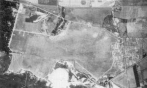 Aerial Photo of Warmwell Airfield - 16 August 1943 | |
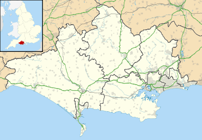 RAF Warmwell, shown within Dorset | |
| Coordinates | 50°41′50″N 002°20′40″W / 50.69722°N 2.34444°WCoordinates: 50°41′50″N 002°20′40″W / 50.69722°N 2.34444°W |
| Type | Royal Air Force station |
| Code | XW |
| Site information | |
| Controlled by |
Royal Air Force United States Army Air Forces |
| Condition | Disused, airfield site reverted to quarrying (two hangars remain), technical site became a housing estate, some aircraft hardstands survive alongside road bordering the north side of the airfield where the control tower remains but has been converted to a house. |
| Site history | |
| Built | 1936 |
| Built by | Royal Air Force |
| In use | 1937-1946 |
| Battles/wars |
European Theatre of World War II Air Offensive, Europe July 1942 - May 1945 |
| Garrison information | |
| Garrison |
RAF Fighter Command Ninth Air Force |
| Occupants |
152, 174, 175, 234, 263, 275, 276, 402 & 609 Squadrons, RAF 474th Fighter Group, 9th USAAF |
RAF Warmwell is a former Royal Air Force station near Warmwell in Dorset, England from 1937 to 1946, located about 5 miles east-southeast of Dorchester; 100 miles southwest of London.
During the Second World War it was used by the Royal Air Force and the United States Army Air Forces Ninth Air Force.
History
USAAF use
While under USAAF control, Warmwell was known as USAAF Station AAF-454 for security reasons, and by which it was referred to instead of location. Its Station-ID was "XW".
474th Fighter Group
The 474th Fighter Group arrived on 12 March 1944 from Oxnard Flight Strip California[1] flying Lockheed P-38 "Lightnings". Operational squadrons of the group were:
- 428th Fighter Squadron (F5)
- 429th Fighter Squadron (7Y)
- 430th Fighter Squadron (K6)
The 474th was a group of Ninth Air Force's 70th Fighter Wing, IX Tactical Air Command.
The group continued operations on the continent providing tactical air support in support of U.S. First Army until V-E Day, being stationed at Bad Langensalza, Germany (ALG R-2) at the end of hostilities. The 474th FG returned to Camp Kilmer, New Jersey during November 1945 and was inactivated on 8 December 1945.


Current use
The site on which RAF Warmwell once lay is now a small village called Crossways, the original taxiway is still in use as a road through the village (where two dispersal pans still remain), and the old station cinema is now the village hall, the old ATC tower has now been converted into a dwelling (Egdon House) that has been extensively modified and is not easily recognisable as such. Two bellman style hangars still remain, rumoured to be used by local farmers for fertilizer storage, and other buildings exist in the woodland areas surrounding Crossways, although some have been demolished. One of the base's billets is now one of the local shops. During clearance work in preparation for new buildings on the North East side of the old airfield a brick block house and a concrete rifle range were revealed. Both have now been demolished but the photographs shown were taken just prior to their removal. Further clearance to build an access road has resulted in the excavation of a group of the aircraft tie-down points.
See also
References
![]()
Citations
- ↑ Maurer 1980, p. 347.
Bibliography
- Freeman, Roger A. (1994) UK Airfields of the Ninth: Then and Now 1994. After the Battle ISBN 0-900913-80-0
- Freeman, Roger A. (1996) The Ninth Air Force in Colour: UK and the Continent-World War Two. After the Battle ISBN 1-85409-272-3
- Maurer, M. Air Force Combat Units Of World War II. USAF Historical Division. Washington D.C., USA: Zenger Publishing Co., Inc, 1980. ISBN 0-89201-092-4.
- USAAS-USAAC-USAAF-USAF Aircraft Serial Numbers--1908 to present
- Anthony Cooke (2000) Reflections of RAF Warmwell: ISBN 0-9539052-0-9
- Anthony Cooke (1995) Airfield Focus - 21: Warmwell . ISBN 1 870384 42 3
External links
| Wikimedia Commons has media related to RAF Warmwell. |
- RAF Warmwell on Dorset Airfields
- RAF Warmwell: WW2 Dorset RAF Airbase
- Photographs on worldwar2airfields.net
- 152 Hyderabad
Royal Air Force portal | ||
| Formations and units |  | |
| Branches and components | ||
| Reserve forces | ||
| Associated civil organisations | ||
| Equipment | ||
| Personnel | ||
| Appointments | ||
| Symbols and uniform | ||
.svg.png)