Abbey, Saskatchewan
| Abbey | |
|---|---|
| Village | |
| Village of Abbey | |
 Abbey  Abbey | |
| Coordinates: 50°43′59″N 108°45′00″W / 50.733°N 108.750°W | |
| Country |
|
| Province |
|
| Region | Southwest |
| Census division | 8 |
| Rural Municipality | Miry Creek No. 229 |
| Post office founded | August 1, 1913 |
| Incorporated (Village) | September 2, 1913 |
| Government | |
| • Governing body | Abbey Village Council |
| • Mayor | Bruce Walker |
| • Administrator | Jan Stern |
| Area | |
| • Total | 0.77 km2 (0.30 sq mi) |
| Elevation | 681 m (2,235 ft) |
| Population (2016) | |
| • Total | 115 |
| • Density | 149.1/km2 (386/sq mi) |
| Time zone | UTC-6 (CST) |
| Postal code | S0N 0A0 |
| Area code(s) | 306 |
| Highways |
Hwy 783 |
| [1][2][3][4] | |
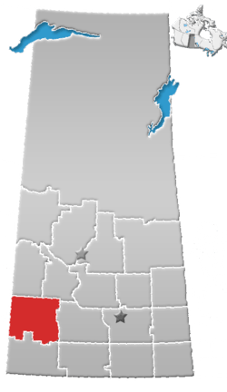
Abbey is a village within the rural municipality of Miry Creek No. 229, in the province of Saskatchewan, Canada. Abbey ranked 4,287 in terms of population in Canada. This village is in the southwestern region of the province, northwest of the city of Swift Current in Division No. 8. Abbey is serviced by Highway 32 near Highway 738.
History
In 1910 the first post office used by area residents was Longworth, located in the home of Cassie Baldwin.[5]
The town site of Abbey was originally owned by a man named D.F. Kennedy. In 1913 Canadian Pacific Railway bought a quarter section of land from him to build a rail line.[5] The C.P.R. gave Mr. Kennedy the honour of naming the town, giving it the name Abbey - the name of the Kennedy farm in Ireland.[6]
Abbey has one municipal heritage property, the Abbey Fire Hall. Constructed in 1919 in response to a large fire that threatened the community in September 1918, the fire station was constructed as part of an upgrade to fire protection in the town. The station remained in service until a new fire station was constructed in 1975. The station is currently not in use, however the siren on the station tower is still used to signal emergencies in the town.[7]
Demographics
| Canada census – Abbey, Saskatchewan community profile | |||
|---|---|---|---|
| 2016 | 2011 | 2006 | |
| Population: | 129 (12.2% from 2011) | 115 (-11.5% from 2006) | 130 (-5.1% from 2001) |
| Land area: | 0.77 km2 (0.30 sq mi) | 0.77 km2 (0.30 sq mi) | 0.77 km2 (0.30 sq mi) |
| Population density: | 167.2/km2 (433/sq mi) | 149.1/km2 (386/sq mi) | 168.5/km2 (436/sq mi) |
| Median age: | 52.8 (M: 55.5, F: 52.5) | 53.9 (M: 54.0, F: 53.8) | 49.7 (M: 45.5, F: 51.0) |
| Total private dwellings: | 88 | 82 | 87 |
| Median household income: | |||
| References: 2016[8] 2011[9] 2006[10] earlier[11] | |||
| Visible minorities and Aboriginal population | |||
|---|---|---|---|
| Canada 2006 Census | Population | % of Total Population | |
| Visible minority | 0 | 0 | |
| Aboriginal | 0 | 0 | |
| White | 130 | 100 | |
| Total population | 130 | 100 | |
Geography
Abbey is located south of the South Saskatchewan River and north of The Great Sand Hills.
Area statistics
- Lat (DMS) 50° 44' 00" N
- Long (DMS) 108° 45' 00" W
- Dominion Land Survey Section 36 - Township 6 - Range 31 West of the 1st, 2nd or 3rd Meridian
- Time zone (cst) UTC−6
Climate
Abbey experiences a semi-arid climate (Köppen climate classification BSk) with long, cold, dry winters and short, warm summers. Precipitation is low, with an annual average of 315mm, and is concentrated in the warmer months.
| Climate data for Abbey | |||||||||||||
|---|---|---|---|---|---|---|---|---|---|---|---|---|---|
| Month | Jan | Feb | Mar | Apr | May | Jun | Jul | Aug | Sep | Oct | Nov | Dec | Year |
| Record high °C (°F) | 13.9 (57) |
17 (63) |
23 (73) |
31.5 (88.7) |
35 (95) |
39 (102) |
37 (99) |
41.1 (106) |
37.8 (100) |
33.9 (93) |
25 (77) |
16 (61) |
41.1 (106) |
| Average high °C (°F) | −8.1 (17.4) |
−3.7 (25.3) |
3.4 (38.1) |
12.5 (54.5) |
18.6 (65.5) |
23.2 (73.8) |
25.9 (78.6) |
25.9 (78.6) |
19.4 (66.9) |
12.4 (54.3) |
1.1 (34) |
−5.6 (21.9) |
10.4 (50.7) |
| Daily mean °C (°F) | −13.1 (8.4) |
−8.7 (16.3) |
−1.8 (28.8) |
5.9 (42.6) |
11.8 (53.2) |
16.3 (61.3) |
18.7 (65.7) |
18.5 (65.3) |
12.5 (54.5) |
6.1 (43) |
−3.9 (25) |
−10.6 (12.9) |
4.3 (39.7) |
| Average low °C (°F) | −18.1 (−0.6) |
−13.7 (7.3) |
−7 (19) |
−0.6 (30.9) |
5 (41) |
9.5 (49.1) |
11.5 (52.7) |
11 (52) |
5.7 (42.3) |
−0.3 (31.5) |
−8.8 (16.2) |
−15.6 (3.9) |
−1.8 (28.8) |
| Record low °C (°F) | −43.3 (−45.9) |
−42 (−44) |
−35 (−31) |
−20 (−4) |
−9 (16) |
−4 (25) |
2.5 (36.5) |
0 (32) |
−7.8 (18) |
−27 (−17) |
−36 (−33) |
−44 (−47) |
−44 (−47) |
| Average precipitation mm (inches) | 13.2 (0.52) |
9.2 (0.362) |
15.1 (0.594) |
21.4 (0.843) |
43.3 (1.705) |
60.4 (2.378) |
51.1 (2.012) |
29.5 (1.161) |
25.7 (1.012) |
15.1 (0.594) |
13.1 (0.516) |
17.5 (0.689) |
314.5 (12.382) |
| Source: Environment Canada[12] | |||||||||||||
See also
References
- ↑ "2011 Community Profiles". Statistics Canada. Government of Canada. Retrieved 2014-04-09.
- ↑ National Archives, Archivia Net. "Post Offices and Postmasters". Archived from the original on 2006-10-06. Retrieved 2014-07-15.
- ↑ Government of Saskatchewan, MRD Home. "Municipal Directory System". Archived from the original on 2016-01-15. Retrieved 2014-07-15.
- ↑ Commissioner of Canada Elections, Chief Electoral Officer of Canada (2005). "Elections Canada On-line". Archived from the original on 2007-04-21. Retrieved 2014-07-15.
- 1 2 Russell, E. T. (1973), What's In a Name?, Saskatoon, Saskatchewan: Western Producer Book Service, p1
- ↑ Our Roots History of Abbey Retrieved on 2008-12-14
- ↑ Abbey Fire Hall Heritage Property Details Archived March 14, 2012, at the Wayback Machine.
- ↑ "2016 Community Profiles". Canada 2016 Census. Statistics Canada. February 21, 2017. Retrieved 2017-03-15.
- ↑ "2011 Community Profiles". Canada 2011 Census. Statistics Canada. July 5, 2013. Retrieved 2012-10-14.
- ↑ "2006 Community Profiles". Canada 2006 Census. Statistics Canada. March 30, 2011. Retrieved 2009-02-24.
- ↑ "2001 Community Profiles". Canada 2001 Census. Statistics Canada. February 17, 2012.
- ↑ Environment Canada Canadian Climate Normals 1971–2000, accessed 23 July 2010
External links
- Abbey's population Data
- Saskatchewan City & Town Maps
- Saskatchewan Gen Web - One Room School Project
- Post Offices and Postmasters - ArchiviaNet - Library and Archives Canada
- Saskatchewan Gen Web Region
- Online Historical Map Digitization Project
- GeoNames Query
- 2006 Community Profiles
- Sask Cemeteries by Community and RM RM No. 229 - Miry Creek
Places adjacent to Abbey, Saskatchewan | ||||||||||
|---|---|---|---|---|---|---|---|---|---|---|
| ||||||||||
| Subdivisions | |
|---|---|
| Communities | |
| Cities | |
| Topics |
|
| |