22nd Street station (Caltrain)
22nd Street | |||||||||||||||||||
|---|---|---|---|---|---|---|---|---|---|---|---|---|---|---|---|---|---|---|---|
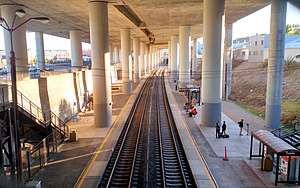 22nd Street station under the I-280 viaduct in 2017 | |||||||||||||||||||
| Location |
1149 22nd Street San Francisco, California | ||||||||||||||||||
| Coordinates | 37°45′26″N 122°23′33″W / 37.75722°N 122.39250°WCoordinates: 37°45′26″N 122°23′33″W / 37.75722°N 122.39250°W | ||||||||||||||||||
| Owned by | Peninsula Corridor Joint Powers Board | ||||||||||||||||||
| Line(s) | Peninsula Subdivision[1] | ||||||||||||||||||
| Platforms | 2 side platforms | ||||||||||||||||||
| Tracks | 2 | ||||||||||||||||||
| Connections |
| ||||||||||||||||||
| Other information | |||||||||||||||||||
| Fare zone | Fare Zone 1 | ||||||||||||||||||
| History | |||||||||||||||||||
| Opened | 1907 | ||||||||||||||||||
| Traffic | |||||||||||||||||||
| Passengers (2017) | 1696 per weekday[2] | ||||||||||||||||||
| Services | |||||||||||||||||||
| |||||||||||||||||||
22nd Street is a Caltrain commuter rail station located south of 22nd Street beneath the I-280 freeway between the Dogpatch and Potrero Hill neighborhoods of San Francisco, California. The only below-grade Caltrain station, it is bracketed by two tunnels which take the line under the eastern slope of Potrero Hill. The station is reached by stairways from 22nd Street and is not handicapped accessible.
The station opened when the Southern Pacific Railroad built the Bayshore Cutoff in 1907. The station was originally known as 23rd Street.[3]
Bus connections
- Muni: 48 Quintara-24th Street
References
- ↑ SMA Rail Consulting (April 2016). "California Passenger Rail NETWORK SCHEMATICS" (PDF). California Department of Transportation. p. 13.
- ↑ "2017 Annual Count Key Findings Report" (PDF). Caltrain. 2017.
- ↑ "Southern Pacific Peninsula Time Tables". Southern Pacific Lines. April 1, 1978. Archived from the original on July 1, 2007.
External links
![]()
| Stations |
| |
|---|---|---|
| Connecting services | ||
| Management | ||
| History | ||
| Projects |
| |
| Miscellaneous | ||
Category | ||
This article is issued from
Wikipedia.
The text is licensed under Creative Commons - Attribution - Sharealike.
Additional terms may apply for the media files.