Sherborne (Dorset)
Sherborne is een civil parish in het bestuurlijke gebied Dorset, in het Engelse graafschap Dorset. De plaats telt 9523 inwoners.
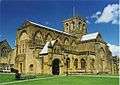 Kerk van Sherborne
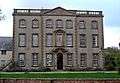 Sherborne House
 Armenhuisjes in Sherborne
| Douzelage | |
|---|---|
|
Altea · Bad Kötzting · Bellagio · Bundoran · Chojna · Granville · Holstebro · Houffalize · Judenburg · Karkkila · Kőszeg · Meerssen · Niederanven · Oxelösund · Preveza · Rovinj · Sesimbra · Sherborne · Sigulda · Sušice · Türi | |
Abbotsbury · Affpuddle · Alderholt · Allington · Alton Pancras · Anderson · Arne · Ashmore · Askerswell · Athelhampton · Batcombe · Beaminster · Beer Hackett · Bere Regis · Bettiscombe · Bincombe · Bishop's Caundle · Blandford Forum · Blandford St. Mary · Bloxworth · Bothenhampton · Bourton · Bradford Abbas · Bradford Peverell · Bradpole · Bridport · Broadmayne · Broadwindsor · Bryanston · Buckhorn Weston · Buckland Newton · Burleston · Burstock · Burton · Burton Bradstock · Cann · Castleton · Cattistock · Caundle Marsh · Cerne Abbas · Chalbury · Chaldon Herring · Charlton Marshall · Charminster · Charmouth · Chedington · Cheselbourne · Chetnole · Chettle · Chickerell · Chideock · Child Okeford · Chilfrome · Church Knowle · Clifton Maybank · Colehill · Compton Abbas · Compton Valence · Coombe Keynes · Corfe Castle · Corfe Mullen · Corscombe · Cranborne · Crossways · Dewlish · Dorchester · Durweston · East Chelborough · East Holme · East Lulworth · East Orchard · East Stoke · East Stour · Edmondsham · Evershot · Farnham · Ferndown · Fifehead Magdalen · Fifehead Neville · Fleet · Folke · Fontmell Magna · Frampton · Frome St. Quintin · Frome Vauchurch · Gillingham · Glanvilles Wootton · Goathill · Godmanstone · Gussage All Saints · Gussage St. Michael · Halstock · Hammoon · Hanford · Hazelbury Bryan · Hermitage · Hilfield · Hilton · Hinton Martell · Hinton Parva · Hinton St. Mary · Holnest · Holt · Holwell · Hooke · Horton · Hurn · Ibberton · Isle of Portland · Iwerne Courtney · Iwerne Minster · Iwerne Steepleton · Kimmeridge · Kingston Russell · Kington Magna · Langton Herring · Langton Long Blandford · Langton Matravers · Leigh · Leweston · Lillington · Littlebredy · Litton Cheney · Loders · Long Bredy · Long Crichel · Longburton · Lydlinch · Lyme Regis · Lytchett Matravers · Lytchett Minster and Upton · Maiden Newton · Manston · Mapperton · Mappowder · Margaret Marsh · Marnhull · Marshwood · Melbury Abbas · Melbury Bubb · Melbury Osmond · Melcombe Horsey · Milborne St. Andrew · Milton Abbas · Minterne Magna · Moor Crichel · Morden · Moreton · Mosterton · Motcombe · Nether Cerne · Nether Compton · Netherbury · North Poorton · Oborne · Okeford Fitzpaine · Osmington · Over Compton · Owermoigne · Pamphill · Pentridge · Piddlehinton · Piddletrenthide · Pilsdon · Pimperne · Portesham · Powerstock · Poyntington · Puddletown · Pulham · Puncknowle · Purse Caundle · Rampisham · Ryme Intrinseca · Sandford Orcas · Seaborough · Shaftesbury · Shapwick · Sherborne · Shillingstone · Shipton Gorge · Silton · Sixpenny Handley · South Perrott · Spetisbury · St. Leonards and St. Ives · Stalbridge · Stanton St. Gabriel · Steeple · Stinsford · Stockwood · Stoke Abbott · Stoke Wake · Stour Provost · Stourpaine · Stourton Caundle · Stratton · Studland · Sturminster Marshall · Sturminster Newton · Sutton Waldron · Swanage · Swyre · Sydling St. Nicholas · Symondsbury · Tarrant Crawford · Tarrant Gunville · Tarrant Hinton · Tarrant Keyneston · Tarrant Launceston · Tarrant Monkton · Tarrant Rawston · Tarrant Rushton · Thorncombe · Thornford · Tincleton · Todber · Toller Fratrum · Toller Porcorum · Tolpuddle · Trent · Turners Puddle · Turnworth · Up Cerne · Verwood · Wareham · Wareham St. Martin · Wareham Town · Warmwell · West Chelborough · West Compton · West Knighton · West Lulworth · West Moors · West Orchard · West Parley · West Stafford · West Stour · Whitcombe · Whitchurch Canonicorum · Wimborne Minster · Wimborne St. Giles · Winfrith Newburgh · Winterborne Came · Winterborne Clenston · Winterborne Herringston · Winterborne Houghton · Winterborne Kingston · Winterborne Monkton · Winterborne St. Martin · Winterborne Stickland · Winterborne Whitechurch · Winterborne Zelston · Winterbourne Abbas · Winterbourne Steepleton · Witchampton · Woodlands · Woodsford · Wool · Woolland · Wootton Fitzpaine · Worth Matravers · Wynford Eagle · Yetminster
Geplaatst op: 09-07-2007 |
Dit artikel is een beginnetje over landen & volken. U wordt uitgenodigd om op bewerken te klikken om uw kennis aan dit artikel toe te voegen. |
| Civil parish in Engeland | |||
 | |||
| Situering | |||
| Regio | South West England | ||
| Graafschap | Dorset | ||
| District | West Dorset | ||
| Coördinaten | 50° 57' NB, 2° 31' WL | ||
| Algemeen | |||
| Oppervlakte | 6,6810 km² | ||
| Inwoners (2011) | 9523 (1425 inw./km²) | ||
| Overig | |||
| Postcode(s) | DT9 | ||
| Grid code | ST638165 | ||
| Post town | Sherborne | ||
| ONS-code | E04003593 | ||
| Foto's | |||
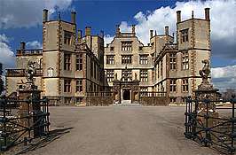 | |||
| Kasteel van Sherborne | |||
| |||