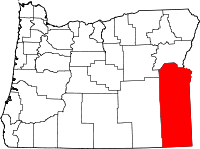
Malheur County
Malheur County is een van de 36 county's in de Amerikaanse staat Oregon.
| County in de Verenigde Staten | |||
 | |||
| Situering | |||
| Staat | Oregon | ||
| Tijdzone | Mountain Standard Time (UTC−7) | ||
| Coördinaten | 43°12'36"NB, 117°37'48"WL | ||
| Algemeen | |||
| Oppervlakte | 25.718 km² | ||
| - land | 25.607 km² | ||
| - water | 111 km² | ||
| Inwoners (2000) | 31.615 (1 inw./km²) | ||
| Overig | |||
| Zetel | Vale (Oregon) | ||
| FIPS-code | 41045 | ||
| Opgericht | 1887 | ||
| Foto's | |||
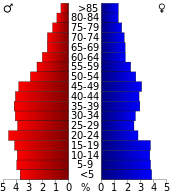 Bevolkingspiramide Malheur County | |||
| Statistieken volkstelling Malheur County | |||
| |||
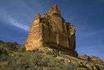
Leslie Gulch
De county heeft een landoppervlakte van 25.607 km² en telt 31.615 inwoners (volkstelling 2000). De hoofdplaats is Vale (Oregon).
Geschiedenis
Malheur werd op 17 februari 1887 gevormd via afsplitsing van Baker County. Een belangrijke impuls vormde de ontdekking van goud in 1863.
Bevolkingsontwikkeling
| Historische inwonertallen | |||
|---|---|---|---|
| Jaar | Inwoners | % ± | |
| 1900 | 4.203 | ||
| 1910 | 8.601 | 104,6% | |
| 1920 | 10.907 | 26,8% | |
| 1930 | 11.269 | 3,3% | |
| 1940 | 19.767 | 75,4% | |
| 1950 | 23.223 | 17,5% | |
| 1960 | 22.764 | −2,0% | |
| 1970 | 23.169 | 1,8% | |
| 1980 | 26.896 | 16,1% | |
| 1990 | 26.038 | −3,2% | |
| 2000 | 31.615 | 21,4% | |
| Bron: (en) Historical Decennial Census Population | |||
| County's in Oregon |
|---|
|
Baker · Benton · Clackamas · Clatsop · Columbia · Coos · Crook · Curry · Deschutes · Douglas · Gilliam · Grant · Harney · Hood River · Jackson · Jefferson · Josephine · Klamath · Lake · Lane · Lincoln · Linn · Malheur · Marion · Morrow · Multnomah · Polk · Sherman · Tillamook · Umatilla · Union · Wallowa · Wasco · Washington · Wheeler · Yamhill |
This article is issued from
Wikipedia.
The text is licensed under Creative
Commons - Attribution - Sharealike.
Additional terms may apply for the media files.