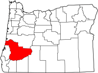
Douglas County (Oregon)
Douglas County is een van de 36 county's in de Amerikaanse staat Oregon.
| County in de Verenigde Staten | |||
 | |||
| Situering | |||
| Staat | Oregon | ||
| Tijdzone | Mountain Standard Time (UTC−7) | ||
| Coördinaten | 43°17'24"NB, 123°10'48"WL | ||
| Algemeen | |||
| Oppervlakte | 13.297 km² | ||
| - land | 13.045 km² | ||
| - water | 252 km² | ||
| Inwoners (2000) | 100.399 (8 inw./km²) | ||
| Overig | |||
| Zetel | Roseburg | ||
| FIPS-code | 41019 | ||
| Opgericht | 1852 | ||
| Foto's | |||
 Bevolkingspiramide Douglas County | |||
| Statistieken volkstelling Douglas County | |||
| |||
De county heeft een landoppervlakte van 13.045 km² en telt 100.399 inwoners (volkstelling 2000). De hoofdplaats is Roseburg.
Bevolkingsontwikkeling
| Historische inwonertallen | |||
|---|---|---|---|
| Jaar | Inwoners | % ± | |
| 1900 | 14.565 | ||
| 1910 | 19.674 | 35,1% | |
| 1920 | 21.332 | 8,4% | |
| 1930 | 21.965 | 3,0% | |
| 1940 | 25.728 | 17,1% | |
| 1950 | 54.549 | 112,0% | |
| 1960 | 68.458 | 25,5% | |
| 1970 | 71.743 | 4,8% | |
| 1980 | 93.748 | 30,7% | |
| 1990 | 94.649 | 1,0% | |
| 2000 | 100.399 | 6,1% | |
| Bron: (en) Historical Decennial Census Population | |||
| County's in Oregon |
|---|
|
Baker · Benton · Clackamas · Clatsop · Columbia · Coos · Crook · Curry · Deschutes · Douglas · Gilliam · Grant · Harney · Hood River · Jackson · Jefferson · Josephine · Klamath · Lake · Lane · Lincoln · Linn · Malheur · Marion · Morrow · Multnomah · Polk · Sherman · Tillamook · Umatilla · Union · Wallowa · Wasco · Washington · Wheeler · Yamhill |
| Zie de categorie Douglas County, Oregon van Wikimedia Commons voor mediabestanden over dit onderwerp. |
This article is issued from
Wikipedia.
The text is licensed under Creative
Commons - Attribution - Sharealike.
Additional terms may apply for the media files.