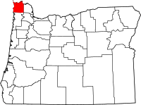
Clatsop County
Clatsop County is een van de 36 county's in de Amerikaanse staat Oregon.
| County in de Verenigde Staten | |||
 | |||
| Situering | |||
| Staat | Oregon | ||
| Tijdzone | Mountain Standard Time (UTC−7) | ||
| Coördinaten | 46°0'36"NB, 123°42'36"WL | ||
| Algemeen | |||
| Oppervlakte | 2.810 km² | ||
| - land | 2.143 km² | ||
| - water | 667 km² | ||
| Inwoners (2000) | 35.630 (17 inw./km²) | ||
| Overig | |||
| Zetel | Astoria | ||
| FIPS-code | 41007 | ||
| Opgericht | 1844 | ||
| Foto's | |||
 Bevolkingspiramide Clatsop County | |||
| Statistieken volkstelling Clatsop County | |||
| |||
De county heeft een landoppervlakte van 2.143 km² en telt 35.630 inwoners (volkstelling 2000). De hoofdplaats is Astoria.
Bevolkingsontwikkeling
| Historische inwonertallen | |||
|---|---|---|---|
| Jaar | Inwoners | % ± | |
| 1900 | 12.765 | ||
| 1910 | 16.106 | 26,2% | |
| 1920 | 23.030 | 43,0% | |
| 1930 | 21.124 | −8,3% | |
| 1940 | 24.697 | 16,9% | |
| 1950 | 30.776 | 24,6% | |
| 1960 | 27.380 | −11,0% | |
| 1970 | 28.473 | 4,0% | |
| 1980 | 32.489 | 14,1% | |
| 1990 | 33.301 | 2,5% | |
| 2000 | 35.630 | 7,0% | |
| Bron: (en) Historical Decennial Census Population | |||
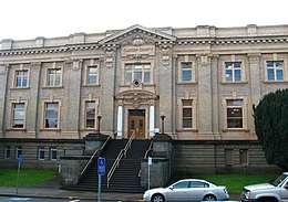
Clatsop County Courthouse
| County's in Oregon |
|---|
|
Baker · Benton · Clackamas · Clatsop · Columbia · Coos · Crook · Curry · Deschutes · Douglas · Gilliam · Grant · Harney · Hood River · Jackson · Jefferson · Josephine · Klamath · Lake · Lane · Lincoln · Linn · Malheur · Marion · Morrow · Multnomah · Polk · Sherman · Tillamook · Umatilla · Union · Wallowa · Wasco · Washington · Wheeler · Yamhill |
This article is issued from
Wikipedia.
The text is licensed under Creative
Commons - Attribution - Sharealike.
Additional terms may apply for the media files.