St Albans (district)
St Albans is een district met de officiële titel van city, in het shire-graafschap (non-metropolitan county OF county) Hertfordshire en telt 147.000 inwoners. De oppervlakte bedraagt 161 km².
| Niet-metropolitaans district in Engeland | |||
  | |||
| Situering | |||
| Land | Engeland | ||
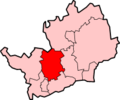
| County | Hertfordshire | ||
| Regio | East of England | ||
| Coördinaten | 51°47'NB, 0°20'WL | ||
| Algemeen | |||
| Oppervlakte | 161,2058[1] km² | ||
| Inwoners (2018[2]) | 147373 (914 inw./km²) | ||
| ONS-code | E07000240 | ||
| |||
Van de bevolking is 14,9% ouder dan 65 jaar. De werkloosheid bedraagt 1,7% van de beroepsbevolking (cijfers volkstelling 2001).
De stad St Albans telt ongeveer 58.000 inwoners.
Plaatsen in district St Albans
Civil parishes in district St Albans
Colney Heath, Harpenden, Harpenden Rural, London Colney, Redbourn, Sandridge, St Michael, St Stephen, Wheathampstead.
Bronnen, noten en/of referenties
|
| Plaatsen en entiteiten met de status van stad (city) in het Verenigd Koninkrijk | ||||||||||
|---|---|---|---|---|---|---|---|---|---|---|
| ||||||||||
This article is issued from
Wikipedia.
The text is licensed under Creative
Commons - Attribution - Sharealike.
Additional terms may apply for the media files.